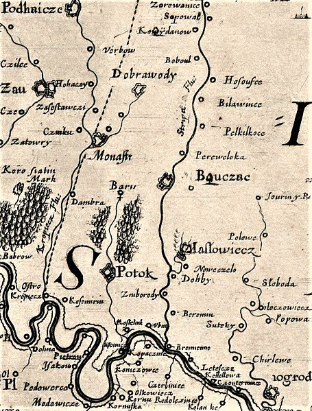
File:Beauplan special fragment 7 Buchach.jpg
Jump to navigation
Jump to search

Size of this preview: 455 × 599 pixels. Other resolutions: 182 × 240 pixels | 365 × 480 pixels | 772 × 1,016 pixels.
Original file (772 × 1,016 pixels, file size: 409 KB, MIME type: image/jpeg)
Captions
Captions
Add a one-line explanation of what this file represents
Summary
[edit]
| Description | ||||||||||||||||||||
| Date | ||||||||||||||||||||
| Source | http://freemap.com.ua/maps/boplan/1-4.jpg | |||||||||||||||||||
| Author |
|
|||||||||||||||||||
Licensing
[edit]
|
This work is in the public domain in its country of origin and other countries and areas where the copyright term is the author's life plus 70 years or fewer. This work is in the public domain in the United States because it was published (or registered with the U.S. Copyright Office) before January 1, 1929. | |
| This file has been identified as being free of known restrictions under copyright law, including all related and neighboring rights. | |
File history
Click on a date/time to view the file as it appeared at that time.
| Date/Time | Thumbnail | Dimensions | User | Comment | |
|---|---|---|---|---|---|
| current | 23:00, 22 April 2017 | | 772 × 1,016 (409 KB) | Magen (talk | contribs) | Mapa obrócona. Północ - południe, wg kierunków geograficznych |
| 07:41, 16 February 2016 |  | 772 × 1,016 (527 KB) | Микола Василечко (talk | contribs) | User created page with UploadWizard |
You cannot overwrite this file.
File usage on Commons
The following 17 pages use this file:
- Category:Barysh, Chortkiv Raion
- Category:Births in Barysh, Chortkiv Raion
- Category:Births in Kydaniv
- Category:Dobrovody, Chortkiv Raion
- Category:Duliby, Ternopil Oblast
- Category:Isakiv
- Category:Kolinky
- Category:Kopachyntsi
- Category:Koshylivtsi
- Category:Kosmyryn
- Category:Kostilnyky
- Category:Kydaniv
- Category:Podillia, Chortkiv Raion
- Category:Polivtsi
- Category:Popivtsi, Chortkiv Raion
- Category:Unizh
- Category:Verbiv, Pidhaitsi Hromada
File usage on other wikis
The following other wikis use this file:
- Usage on ceb.wikipedia.org
- Usage on ce.wikipedia.org
- Олеша (Ивано-Франковскан область)
- Исаков (Ивано-Франковскан область)
- Колинки (Ивано-Франковскан область)
- Копачинцы
- Корнев (Ивано-Франковскан область)
- Кунисовцы
- Ольховцы (Ивано-Франковскан область)
- Петров (Ивано-Франковскан область)
- Подвербцы
- Барыш (эвла)
- Вербов (Подгайцин гӀалин йукъаралла)
- Доброводы (Чорткиван кӀошт)
- Дулибы (Тернополан область)
- Космирин
- Костильники (Тернополан область)
- Подолье (Залещикин кӀошт)
- Полевцы (Тернополан область)
- Поповцы (Залещикин кӀошт)
- Киданов
- Униж
- Репужинцы (Ивано-Франковскан область)
- Usage on en.wikipedia.org
- Usage on he.wikipedia.org
- Usage on hy.wikipedia.org
- Usage on lt.wikipedia.org
- Usage on pl.wikipedia.org
- Podhajce
- Czerwonogród (obwód tarnopolski)
- Monasterzyska
- Jazłowiec
- Zarwanica (obwód tarnopolski)
- Koropiec
- Barysz
- Niezwiska
- Olesza (obwód iwanofrankiwski)
- Hołhocze
- Zawałów
- Koszyłowce
- Latacz (rejon czortkowski)
- Bobulińce
- Uniż
- Osowce (Ukraina)
- Nowosiółka (rejon buczacki)
- Popowce (rejon czortkowski)
- Sadki (rejon czortkowski)
- Szutromińce
- Sapowa
View more global usage of this file.
Metadata
Categories:
- Ternopil Region on the maps of Guillaume le Vasseur de Beauplan
- 1650 maps
- Maps of Buchach
- Maps of rivers in Ternopil Oblast
- Strypa in Buchach Hromada
- Maps of Dobrovody, Chortkiv Raion
- Maps of Perevoloka, Ternopil Oblast
- Maps of Stari Petlykivtsi
- Maps of Zhnyborody
- Maps of Beremiany, Ternopil Oblast
- Maps of Duliby, Ternopil Oblast
- Maps of Novosilka, Buchach Hromada
- Maps of Hubyn, Ternopil Oblast
- Isakiv
- Kolinky
- Kopachyntsi