File:Bayerische Zugspitzbahn.png
Jump to navigation
Jump to search

Size of this preview: 800 × 515 pixels. Other resolutions: 320 × 206 pixels | 640 × 412 pixels | 1,024 × 660 pixels | 1,280 × 825 pixels | 2,560 × 1,649 pixels | 5,200 × 3,350 pixels.
Original file (5,200 × 3,350 pixels, file size: 7.11 MB, MIME type: image/png)
Captions
Captions
Add a one-line explanation of what this file represents
Summary
[edit]
| Description |
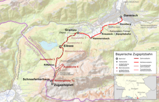
Deutsch: Lagekarte der Bayerische Zugspitzbahn English: map of railway from Garmisch-Partenkirchen up to mountain Zugspitze (Zugspitzplatt). Stations Hausbergbahn, Kreuzeck, Hammersbach, Grainau, Eibsee, Riffelriss and the not realised halt in upper valley Höllental. |
|||||||||
| Date | ||||||||||
| Source |
Map was created using:
|
|||||||||
| Creator |
|
|||||||||
| Permission (Reusing this file) |
|
|||||||||
| Geotemporal data | ||||||||||
| Bounding box |
|
|||||||||
| Georeferencing | ||||||||||
I, the copyright holder of this work, hereby publish it under the following license:
This file is licensed under the Creative Commons Attribution-Share Alike 3.0 Unported license.
Attribution: OpenTopoMap, Peter Christener
- You are free:
- to share – to copy, distribute and transmit the work
- to remix – to adapt the work
- Under the following conditions:
- attribution – You must give appropriate credit, provide a link to the license, and indicate if changes were made. You may do so in any reasonable manner, but not in any way that suggests the licensor endorses you or your use.
- share alike – If you remix, transform, or build upon the material, you must distribute your contributions under the same or compatible license as the original.
| This work is licensed under the Open Database License (summary). |
File history
Click on a date/time to view the file as it appeared at that time.
| Date/Time | Thumbnail | Dimensions | User | Comment | |
|---|---|---|---|---|---|
| current | 17:53, 13 September 2018 | | 5,200 × 3,350 (7.11 MB) | Pechristener (talk | contribs) | Landesgrenze hervorgehoben |
| 09:19, 13 September 2018 |  | 5,200 × 3,350 (8.54 MB) | Pechristener (talk | contribs) | {{Map |Description={{de|1=Lagekarte der {{w|Bayerische Zugspitzbahn||de}}}} |Source = Map was created using: *[http://www.openstreetmap.org/ Open Street Map Data] *[http://opentopomap.org/ Open Topo Map] for background *Germany location map.svg for location map |Author = * Map data (c) OpenStreetMap (and) contributors, CC-BY-SA * File:Germany location map.svg: NordNordWest, [[User:Pa... |
You cannot overwrite this file.
File usage on Commons
The following 7 pages use this file:
- Höllental (Wetterstein)
- User:Anton-kurt/Tyrol new files/2018 September 11-20
- User:Chumwa/OgreBot/Potential transport maps/2018 September 11-20
- User:Chumwa/OgreBot/Public transport information/2018 September 11-20
- User:Chumwa/OgreBot/Transport Maps/2018 September 11-20
- User:Chumwa/OgreBot/Travel and communication maps/2018 September 11-20
- Category:Bayerische Zugspitzbahn
File usage on other wikis
The following other wikis use this file:
- Usage on de.wikipedia.org
- Usage on hu.wikipedia.org
- Usage on pl.wikipedia.org
- Usage on www.wikidata.org