File:Battle of Quiberon Bay - 1759-11-20 - map-fr.svg
Jump to navigation
Jump to search

Size of this PNG preview of this SVG file: 800 × 556 pixels. Other resolutions: 320 × 222 pixels | 640 × 445 pixels | 1,024 × 712 pixels | 1,280 × 890 pixels | 2,560 × 1,779 pixels | 1,820 × 1,265 pixels.
Original file (SVG file, nominally 1,820 × 1,265 pixels, file size: 790 KB)
Captions
Captions
Add a one-line explanation of what this file represents
Summary
[edit]| Description |
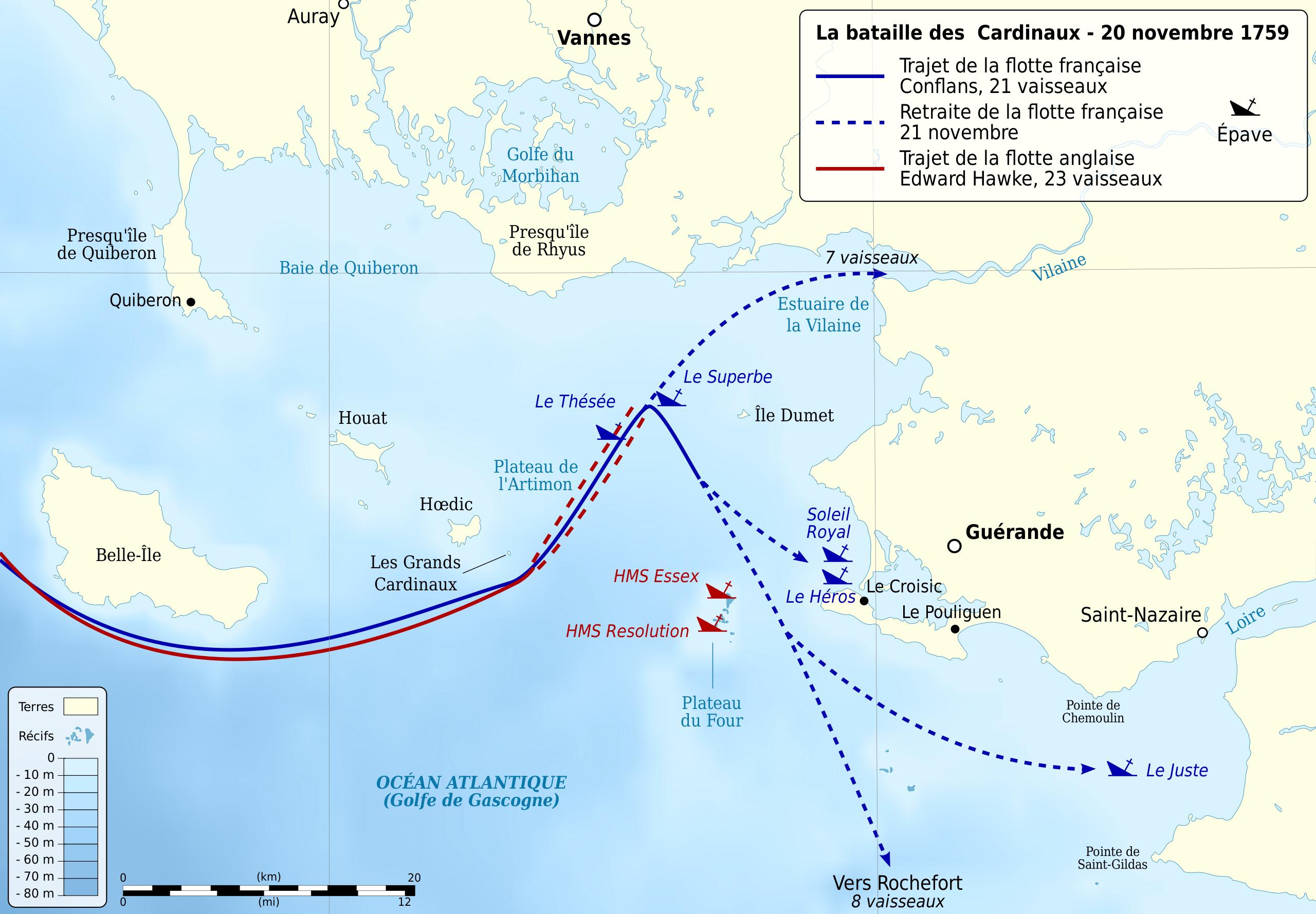
English: Map of the Battle of Quiberon Bay between French fleet lead by Hubert de Brienne de Conflans and English fleet lead by Edward Hawke, 20 november 1759.
Français : Carte de la Bataille des Cardinaux entre la flotte française de Hubert de Brienne de Conflans et la flotte anglaise d'Edward Hawke, le 20 novembre 1759. |
| Date | |
| Source |
Own work.
|
| Author | Sémhur |
| Other versions |
|
| Attribution (required by the license) | © Sémhur / Wikimedia Commons / |
| SVG development |

| Camera location | | View this and other nearby images on: OpenStreetMap |
|---|
Licensing
[edit]
I, the copyright holder of this work, hereby publish it under the following licenses:
| Copyleft: This work of art is free; you can redistribute it and/or modify it according to terms of the Free Art License. You will find a specimen of this license on the Copyleft Attitude site as well as on other sites. |
This file is licensed under the Creative Commons Attribution-Share Alike 4.0 International, 3.0 Unported, 2.5 Generic, 2.0 Generic and 1.0 Generic license.
- You are free:
- to share – to copy, distribute and transmit the work
- to remix – to adapt the work
- Under the following conditions:
- attribution – You must give appropriate credit, provide a link to the license, and indicate if changes were made. You may do so in any reasonable manner, but not in any way that suggests the licensor endorses you or your use.
- share alike – If you remix, transform, or build upon the material, you must distribute your contributions under the same or compatible license as the original.
You may select the license of your choice.
File history
Click on a date/time to view the file as it appeared at that time.
| Date/Time | Thumbnail | Dimensions | User | Comment | |
|---|---|---|---|---|---|
| current | 19:29, 24 April 2016 | | 1,820 × 1,265 (790 KB) | Sémhur (talk | contribs) | Ajout des trajets et nombres de vaisseaux français après la bataille. |
| 11:35, 26 May 2014 |  | 1,820 × 1,265 (788 KB) | Sémhur (talk | contribs) | Valid SVG | |
| 16:01, 4 December 2009 |  | 1,820 × 1,265 (788 KB) | Sémhur (talk | contribs) | Y avait longtemps... | |
| 15:58, 4 December 2009 |  | 512 × 356 (788 KB) | Sémhur (talk | contribs) | == {{int:filedesc}} == {{Information |Description= {{en|1=Map of the battle of Quiberon Bay between French fleet lead by Hubert de Brienne de Conflans and English fleet lead by Edward Hawke, 20 november 1759.}} {{fr|1=Carte |
You cannot overwrite this file.
File usage on Commons
The following page uses this file:
File usage on other wikis
The following other wikis use this file:
- Usage on en.wikipedia.org
- Usage on fr.wikipedia.org
- Bataille des Cardinaux
- Soleil Royal (1749)
- Discussion utilisateur:NicoScPo
- Utilisateur:Rled44/2009
- Héros (1752)
- Inflexible (1755)
- HMS Resolution (1758)
- Thésée (1758)
- Robuste (1758)
- Blocus de la Vilaine
- Juste (1725)
- HMS Essex (1679)
- Superbe (1738)
- Henry Speke
- François de Saint-Allouarn
- Wikipédia:Atelier graphique/Cartes/Archives/mai 2016