File:Bateau de Baba Arroudj ( Jijel ).jpg
![File:Bateau de Baba Arroudj ( Jijel ).jpg](https://upload.wikimedia.org/wikipedia/commons/thumb/9/96/Bateau_de_Baba_Arroudj_%28_Jijel_%29.jpg/800px-Bateau_de_Baba_Arroudj_%28_Jijel_%29.jpg?20150903083940)
Original file (3,264 × 1,832 pixels, file size: 555 KB, MIME type: image/jpeg)
Captions
Captions
Summary
[edit]DescriptionBateau de Baba Arroudj ( Jijel ).jpg |
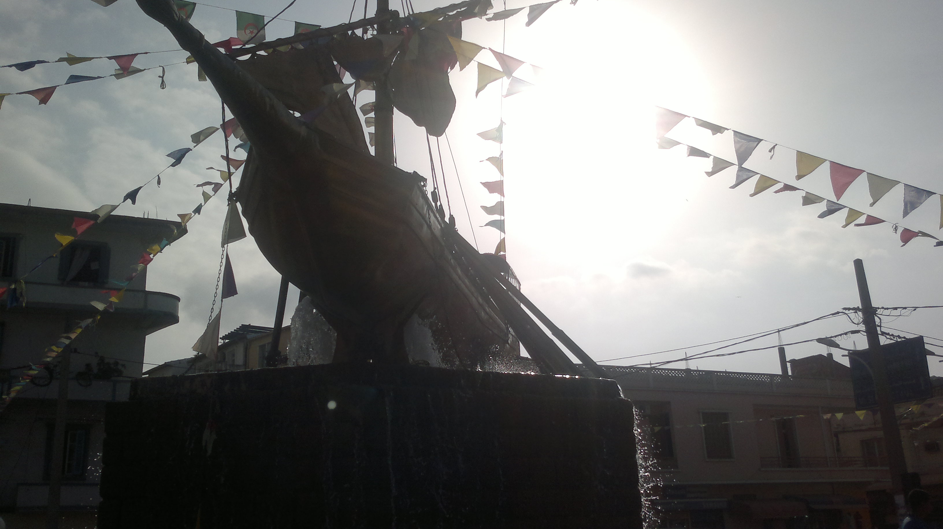
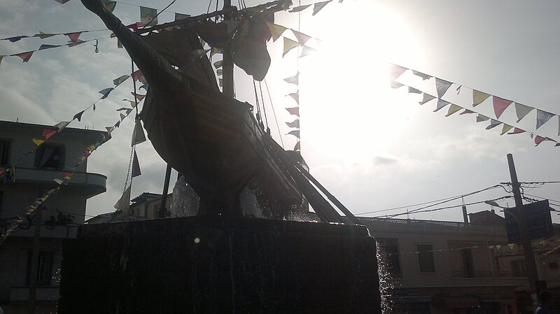
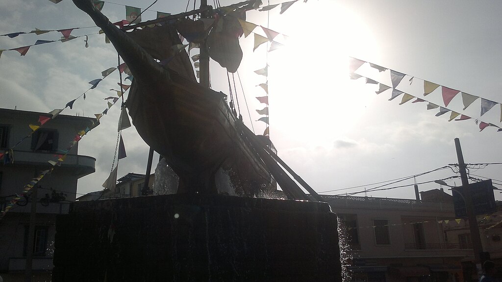
Français : Le bateau est un lieu touristique, intéressant situé sur la rue : l’intersection de la route nationale 43 et rue abd el hamid ben badis dans le centre ville de Jijel. |
Date | |
Source | Own work |
Author | Boumeshel |
Camera location | 36° 48′ 58.5″ N, 5° 46′ 16.31″ E ![]() | View this and other nearby images on: OpenStreetMap | ![]() |
---|
Licensing
[edit]![w:en:Creative Commons](https://upload.wikimedia.org/wikipedia/commons/thumb/7/79/CC_some_rights_reserved.svg/90px-CC_some_rights_reserved.svg.png)
![attribution](https://upload.wikimedia.org/wikipedia/commons/thumb/1/11/Cc-by_new_white.svg/24px-Cc-by_new_white.svg.png)
![share alike](https://upload.wikimedia.org/wikipedia/commons/thumb/d/df/Cc-sa_white.svg/24px-Cc-sa_white.svg.png)
- You are free:
- to share – to copy, distribute and transmit the work
- to remix – to adapt the work
- Under the following conditions:
- attribution – You must give appropriate credit, provide a link to the license, and indicate if changes were made. You may do so in any reasonable manner, but not in any way that suggests the licensor endorses you or your use.
- share alike – If you remix, transform, or build upon the material, you must distribute your contributions under the same or compatible license as the original.
![]() |
This image was uploaded as part of Wiki Loves Monuments 2015.
Afrikaans ∙ Alemannisch ∙ azərbaycanca ∙ Bahasa Indonesia ∙ Bahasa Melayu ∙ Bikol Central ∙ bosanski ∙ brezhoneg ∙ català ∙ čeština ∙ Cymraeg ∙ dansk ∙ davvisámegiella ∙ Deutsch ∙ eesti ∙ English ∙ español ∙ Esperanto ∙ euskara ∙ français ∙ Frysk ∙ Gaeilge ∙ galego ∙ hrvatski ∙ Ido ∙ italiano ∙ latviešu ∙ Lëtzebuergesch ∙ Malagasy ∙ magyar ∙ Malti ∙ Nederlands ∙ norsk ∙ norsk nynorsk ∙ norsk bokmål ∙ polski ∙ português ∙ português do Brasil ∙ română ∙ shqip ∙ sicilianu ∙ slovenčina ∙ slovenščina ∙ suomi ∙ svenska ∙ Tagalog ∙ Türkçe ∙ Yorùbá ∙ Zazaki ∙ Ελληνικά ∙ беларуская ∙ беларуская (тарашкевіца) ∙ български ∙ кыргызча ∙ македонски ∙ русский ∙ српски / srpski ∙ українська ∙ ქართული ∙ հայերեն ∙ नेपाली ∙ हिन्दी ∙ বাংলা ∙ മലയാളം ∙ ไทย ∙ 한국어 ∙ +/− |
![]() |
File history
Click on a date/time to view the file as it appeared at that time.
Date/Time | Thumbnail | Dimensions | User | Comment | |
---|---|---|---|---|---|
current | 08:39, 3 September 2015 | ![]() | 3,264 × 1,832 (555 KB) | Boumeshel (talk | contribs) | User created page with UploadWizard |
You cannot overwrite this file.
File usage on Commons
The following page uses this file:
- File:Hamza ph342.jpg (file redirect)
File usage on other wikis
The following other wikis use this file:
- Usage on ar.wikipedia.org
Metadata
This file contains additional information such as Exif metadata which may have been added by the digital camera, scanner, or software program used to create or digitize it. If the file has been modified from its original state, some details such as the timestamp may not fully reflect those of the original file. The timestamp is only as accurate as the clock in the camera, and it may be completely wrong.
Camera manufacturer | Nokia |
---|---|
Camera model | C7-00 |
Exposure time | 47/250,000 sec (0.000188) |
ISO speed rating | 100 |
Date and time of data generation | 16:59, 23 August 2015 |
Latitude | 36° 48′ 58.5″ N |
Longitude | 5° 46′ 16.31″ E |
Altitude | 48.5 meters above sea level |
Orientation | Normal |
Horizontal resolution | 300 dpi |
Vertical resolution | 300 dpi |
File change date and time | 16:59, 23 August 2015 |
Y and C positioning | Centered |
Exif version | 2.2 |
Date and time of digitizing | 16:59, 23 August 2015 |
Meaning of each component |
|
APEX shutter speed | 12.376 |
Light source | Unknown |
Flash | Flash did not fire, auto mode |
DateTime subseconds | 942 |
DateTimeOriginal subseconds | 942 |
DateTimeDigitized subseconds | 942 |
Supported Flashpix version | 1 |
Color space | sRGB |
Custom image processing | Normal process |
Exposure mode | Auto exposure |
White balance | Auto white balance |
Digital zoom ratio | 1 |
Scene capture type | Standard |
Scene control | None |
Measurement mode | 3-dimensional measurement |
Measurement precision | Fair (1.8) |
Geodetic survey data used | WGS-84 |
GPS tag version | 0.0.2.2 |
Structured data
Items portrayed in this file
depicts
23 August 2015
36°48'58.50313"N, 5°46'16.31428"E
0.000188 second
100
image/jpeg
9d69ced355d4ba71a28539bbe9fef74d47a25395
568,360 byte
1,832 pixel
3,264 pixel
- Files with coordinates missing SDC location of creation
- CC-BY-SA-4.0
- Self-published work
- Images from Wiki Loves Monuments 2015
- Images from Wiki Loves Monuments 2015 in Algeria
- Images from Wiki Loves Monuments missing SDC depicts
- Images from Wiki Loves Monuments missing SDC location of creation
- Uploaded via Campaign:wlm-dz
- Taken with Nokia C7-00
- Algeria photographs taken on 2015-08-23
- Pages with maps