File:Barotse Floodplain (MODIS 2022-05-02).jpg

Original file (1,312 × 1,022 pixels, file size: 1.09 MB, MIME type: image/jpeg)
Captions
Captions
Summary
[edit].jpg&action=edit§ion=1)
| Description |
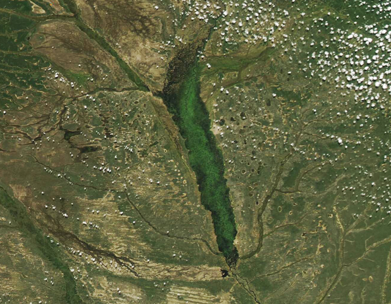
English: The vast Barotse Floodplain sits in the upper Zambezi River Basin in the Western Province of Zambia, South Africa. Spanning more than 2,123 square miles (5,500 square km), the large slightly undulating grassy plains are inundated every year, thanks to the vigorous rainy season of the region. The rains typically peak around January to February, but it usually takes about three months for the rivers to overflow and completely cover the basin with water. The flood usually peaks in April and waters begin to withdraw from May to July, leaving behind enriched, fertile soil that serves as feeding grounds for wild animals and birds, as well as provides excellent agricultural land for the people who live near the basin.
The ebb and flow of the river plays an important role in the life of the Lozi people who have lived in the region for centuries. During the dry season, the Lozi traditionally cultivate and live on large areas of the floodplain. However, the Barotse Floodplain becomes uninhabitable for humans during the floods. Each April, according to long tradition, the Lozi people participate in the Kuomboka ceremony, celebrating the moving of the king of the Lozi to from Lealui, his home in the Barotse Floodplain to Limulunga, his home on higher ground. This movement is accompanied by drums, traditional boats painted black and white and adorned by a large elephant statue, colorful hats, and great fanfare. The return trip to Lealui is usually in August, and that journey is called the Kufuluhela. The Kuomboka ceremony was reinstated in April 2022, after a hiatus of three years—the first due to a dry year without adequate flooding, then the next two due to the COVID pandemic. On April 29, 2022, the Moderate Resolution Imaging Spectroradiometer (MODIS) on board NASA’s Aqua satellite acquired a true-color image on April 29, 2022. The Barotse Floodplain is fully inundated at this time, and the various rivers and tributaries of the region also appear quite full. |
||
| Date | Taken on 29 April 2022 | ||
| Source |
Barotse Floodplain (direct link)
|
||
| Author | MODIS Land Rapid Response Team, NASA GSFC |
| This media is a product of the Aqua mission Credit and attribution belongs to the mission team, if not already specified in the "author" row |
Licensing
[edit].jpg&action=edit§ion=2)
| This file is in the public domain in the United States because it was solely created by NASA. NASA copyright policy states that "NASA material is not protected by copyright unless noted". (See Template:PD-USGov, NASA copyright policy page or JPL Image Use Policy.) | ||
 |
Warnings:
|
File history
Click on a date/time to view the file as it appeared at that time.
| Date/Time | Thumbnail | Dimensions | User | Comment | |
|---|---|---|---|---|---|
| current | 22:06, 9 January 2024 | | 1,312 × 1,022 (1.09 MB) | OptimusPrimeBot (talk | contribs) | #Spacemedia - Upload of http://modis.gsfc.nasa.gov/gallery/images/image05022022_250m.jpg via Commons:Spacemedia |
You cannot overwrite this file.
File usage on Commons
There are no pages that use this file.
.jpg&oldid=840068064)