File:Barnes Ice Cap, Baffin Island, Canada.jpg
Jump to navigation
Jump to search

Size of this preview: 336 × 599 pixels. Other resolutions: 134 × 240 pixels | 269 × 480 pixels | 430 × 768 pixels | 574 × 1,024 pixels | 2,243 × 4,000 pixels.
Original file (2,243 × 4,000 pixels, file size: 4.55 MB, MIME type: image/jpeg)
Captions
Captions
Add a one-line explanation of what this file represents
Summary
[edit]| Description |
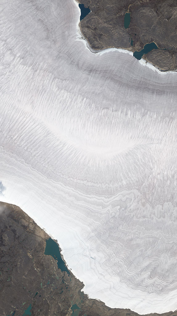
English: Natural-colour image of the Barnes Ice Cap, a bowling-pin-shaped glacier on Canada’s Baffin Island. The image shows a portion of the Barnes Ice Cap near its south-eastern end. Gee Lake sits immediately off the glacier. Resembling growth lines on a clamshell, striations run roughly east-west on the glacier surface. Rather than appearing pristine white, the ice and snow is banded with dust layers spanning time periods that dwarf a human life. By studying ice cores containing such dust layers, climatologists can find clues to ancient climates.
Ted Scambos of the National Snow and Ice Data Center observes that although the ice cap is essentially flat, it appears to undulate, thanks to ridges cut by melt streams running off the glacier. In this summertime shot, the glacier is mostly snow-free except for a band of snow along the edge near Gee Lake. As winter returns, snow will once again cover the glacier, the surrounding land, and the lake. |
| Date | |
| Source | NASA Earth Observatory |
| Author | Jesse Allen and Robert Simmon |
| Other versions |
|

Image captured by The Advanced Land Imager (ALI) on NASA’s Earth Observing-1 (EO-1) satellite. EO-1 ALI data provided courtesy of the NASA EO-1 team.
Licensing
[edit]
| This file is in the public domain in the United States because it was solely created by NASA. NASA copyright policy states that "NASA material is not protected by copyright unless noted". (See Template:PD-USGov, NASA copyright policy page or JPL Image Use Policy.) | ||
 |
Warnings:
|
| Annotations | This image is annotated: View the annotations at Commons |
File history
Click on a date/time to view the file as it appeared at that time.
| Date/Time | Thumbnail | Dimensions | User | Comment | |
|---|---|---|---|---|---|
| current | 10:30, 11 October 2010 | | 2,243 × 4,000 (4.55 MB) | Originalwana (talk | contribs) | {{Information |Description={{en|1=Natural-colour image of the Barnes Ice Cap, a bowling-pin-shaped glacier on Canada’s Baffin Island. The image shows a portion of the Barnes Ice Cap near its south-eastern end. Gee Lake sits immediately off the glaci |
You cannot overwrite this file.
File usage on Commons
The following page uses this file:
File usage on other wikis
The following other wikis use this file:
- Usage on de.wikipedia.org
- Usage on en.wikipedia.org
- Usage on fi.wikipedia.org
- Usage on fr.wikipedia.org