File:Barking Bus Garage (1) (geograph 7752855).jpg
Jump to navigation
Jump to search

Size of this preview: 800 × 600 pixels. Other resolutions: 320 × 240 pixels | 640 × 480 pixels | 1,024 × 768 pixels | 1,280 × 960 pixels | 2,592 × 1,944 pixels.
Original file (2,592 × 1,944 pixels, file size: 1.41 MB, MIME type: image/jpeg)
Captions
Captions
Add a one-line explanation of what this file represents
Summary
[edit]_(geograph_7752855).jpg&action=edit§ion=1)
| Description |
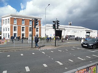
English: Located at 205 Longbridge Road IG11 8UE, it was opened by the London General Omnibus Company on Wednesday 9th January 1924 to meet the demand for bus services in the nearby London County Council housing estates in the Becontree area of Essex. In 1933, LGOC became part of London Transport and over the years this bus garage has seen changes in ownership until Stagecoach London took over its operation in September 1994. It was the last LT bus garage to operate the RT bus, which dated from the late 1940s, until it was finally taken out of service to much fanfare on Saturday 7th April 1979. When this photo was taken, an Open Day was being held to celebrate the garage's 100th anniversary. |
| Date | |
| Source | From geograph.org.uk |
| Author | David Hillas |
| Permission (Reusing this file) |
Creative Commons Attribution Share-alike license 2.0 |
| Attribution (required by the license) | David Hillas / Barking Bus Garage (1) / |
| Camera location | | View this and other nearby images on: OpenStreetMap |
|---|
_(geograph_7752855).jpg¶ms=051.545739_N_0000.093735_E_globe:Earth_type:camera_source:geograph-osgb36(TQ45288506)_heading:0.00&language=en)
| Object location | | View this and other nearby images on: OpenStreetMap |
|---|
_(geograph_7752855).jpg¶ms=051.546280_N_0000.093760_E_globe:Earth_class:object_type:object_source:geograph-osgb36(TQ45288512)_heading:0.00&language=en)
Licensing
[edit]_(geograph_7752855).jpg&action=edit§ion=2)

|
This image was taken from the Geograph project collection. See this photograph's page on the Geograph website for the photographer's contact details. The copyright on this image is owned by David Hillas and is licensed for reuse under the Creative Commons Attribution-ShareAlike 2.0 license.
|
This file is licensed under the Creative Commons Attribution-Share Alike 2.0 Generic license.
Attribution: David Hillas
- You are free:
- to share – to copy, distribute and transmit the work
- to remix – to adapt the work
- Under the following conditions:
- attribution – You must give appropriate credit, provide a link to the license, and indicate if changes were made. You may do so in any reasonable manner, but not in any way that suggests the licensor endorses you or your use.
- share alike – If you remix, transform, or build upon the material, you must distribute your contributions under the same or compatible license as the original.
File history
Click on a date/time to view the file as it appeared at that time.
| Date/Time | Thumbnail | Dimensions | User | Comment | |
|---|---|---|---|---|---|
| current | 13:17, 20 April 2024 | | 2,592 × 1,944 (1.41 MB) | Hullian111-Flickr2Commons (talk | contribs) | == {{int:filedesc}} == {{Information |Description={{en|1=Located at 205 Longbridge Road IG11 8UE, it was opened by the London General Omnibus Company on Wednesday 9th January 1924 to meet the demand for bus services in the nearby London County Council housing estates in the Becontree area of Essex. In 1933, LGOC became part of London Transport and over the years this bus garage has seen changes in ownership until Stagecoach London took over its operation in September 1994. It was the last LT... |
You cannot overwrite this file.
File usage on Commons
There are no pages that use this file.
File usage on other wikis
The following other wikis use this file:
- Usage on en.wikipedia.org
_(geograph_7752855).jpg&oldid=881650292)