File:Banner Adar-Kaia 013 9400.jpg
Jump to navigation
Jump to search
Size of this preview: 798 × 114 pixels. Other resolutions: 320 × 46 pixels | 640 × 91 pixels | 1,024 × 146 pixels | 5,985 × 855 pixels.
Original file (5,985 × 855 pixels, file size: 5.17 MB, MIME type: image/jpeg)
Captions
Captions
Add a one-line explanation of what this file represents
Summary
[edit]
| Description |
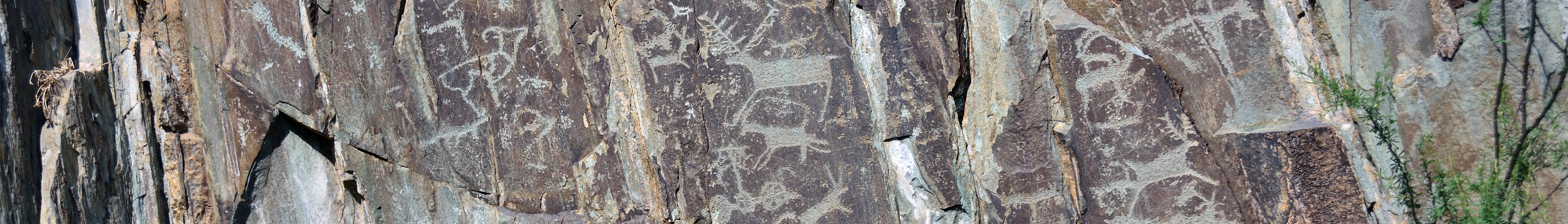
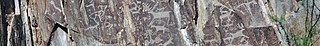
Русский: Оленный камень «Чуйский»: 3,5 км южнее села, Иодро, Онгудайский район, Алтай
English: Wikivoyage banner with petroglyphs of Adar-Kaia Complex, Iodro, Ongudaysky district, Altai Republic, Russia
|
||||
| Date | |||||
| Source | Own work | ||||
| Author | Ludvig14 |
| Camera location | | View this and other nearby images on: OpenStreetMap |
|---|

|
Эта фотография сделана в ходе вики-экспедиции на Алтай, июнь 2021.
This picture was taken during a Russian Wikivoyage expedition. |
Licensing
[edit]
I, the copyright holder of this work, hereby publish it under the following license:
This file is licensed under the Creative Commons Attribution-Share Alike 4.0 International license.
- You are free:
- to share – to copy, distribute and transmit the work
- to remix – to adapt the work
- Under the following conditions:
- attribution – You must give appropriate credit, provide a link to the license, and indicate if changes were made. You may do so in any reasonable manner, but not in any way that suggests the licensor endorses you or your use.
- share alike – If you remix, transform, or build upon the material, you must distribute your contributions under the same or compatible license as the original.
File history
Click on a date/time to view the file as it appeared at that time.
| Date/Time | Thumbnail | Dimensions | User | Comment | |
|---|---|---|---|---|---|
| current | 19:36, 20 February 2022 | 5,985 × 855 (5.17 MB) | Ludvig14 (talk | contribs) | Uploaded own work with UploadWizard |
You cannot overwrite this file.
File usage on Commons
There are no pages that use this file.