File:Banat Josephinische Landaufnahme pg059.jpg
Jump to navigation
Jump to search

Size of this preview: 800 × 543 pixels. Other resolutions: 320 × 217 pixels | 640 × 434 pixels | 1,024 × 695 pixels | 1,280 × 869 pixels | 2,560 × 1,738 pixels | 8,404 × 5,705 pixels.
Original file (8,404 × 5,705 pixels, file size: 31.56 MB, MIME type: image/jpeg)
Captions
Captions
Add a one-line explanation of what this file represents
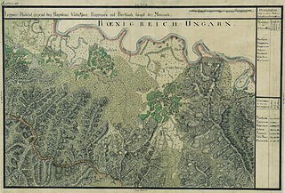
| Name shown on the map Nume din hartă |
Administrative unit Unitate administrativă |
Romanian name Numele românesc |
Hungarian name Numele unguresc |
German name Numele german |
Serbian name Numele sârbesc |
Country today Ţara de astăzi |
|---|---|---|---|---|---|---|
| Barkisch | Krassó megye | Birchiş | Marosberkes, Birkis | Birkisch | Románia | |
| Kappriora | Krassó megye | Căprioara | Kaprevár, Kapriora | Románia | ||
| Kappolnás | Krassó megye | Căpâlnaş | Kápolnás | Románia | ||
| Ostrov | Krassó megye | Ostrov | Marossziget, Szigetfő, Osztrov | Románia | ||
| Pacamesso | Krassó megye | Bacău de Mijloc | Bakamezõ | Románia | ||
| Valla Mare | Krassó megye | Valea Mare | Marosnagyvölgy | Románia | ||
| Weresmort | Krassó megye | Virişmort | Szádvörösmart, Vörösmart | Romania |
Summary
[edit]
| Description |
Deutsch: Das Banat in: Josephinische Landesaufnahme, 1769-72. Josephinische Landaufnahme pg059 English: The Banat region in the cadastral maps: Josephinische Landesaufnahme, 1769-72. Josephinische Landaufnahme pg059 |
||||
| Date | between 1769 and 1772 | ||||
| Source | Österreichisches Staatsarchiv, Kriegsarchiv | ||||
| Author | Historische Militärkarte der österreichisch-ungarischen Monarchie | ||||
| Permission (Reusing this file) |
|
||||
Clickable map of the Banat region
[edit]

File history
Click on a date/time to view the file as it appeared at that time.
| Date/Time | Thumbnail | Dimensions | User | Comment | |
|---|---|---|---|---|---|
| current | 07:02, 3 January 2010 | | 8,404 × 5,705 (31.56 MB) | Asybaris01 (talk | contribs) | {{Information |Description={{ro|1=Banat Josephinische Landaufnahme pg059}} |Source={{own}} |Author=Asybaris01 |Date=1769-72 |Permission= |other_versions= }} Category:Josephinische Landaufnahme |
You cannot overwrite this file.
File usage on Commons
The following 2 pages use this file:
File usage on other wikis
The following other wikis use this file:
- Usage on arz.wikipedia.org
- Usage on de.wikipedia.org
- Usage on hu.wikipedia.org
- Usage on ro.wikipedia.org
- Usage on tt.wikipedia.org
- Usage on www.wikidata.org