File:Bam Island.png
Jump to navigation
Jump to search
No higher resolution available.
Bam_Island.png (504 × 283 pixels, file size: 225 KB, MIME type: image/png)
Captions
Captions
Add a one-line explanation of what this file represents
Summary
[edit]
| Description |
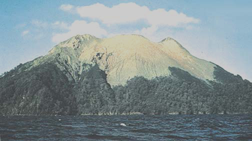
English: Bam Island, easternmost of Schouten Islands (Le Maire Islands), Papua New Guinea, off north coast minus 40 percent brightness processed |
| Date | not stated |
| Source | http://msi.nga.mil/MSISiteContent/StaticFiles/NAV_PUBS/SD/Pub164/Pub164bk.pdf, page 208 |
| Author | Jack Lockwood, USGS |
Licensing
[edit]
This image is in the public domain in the United States because it only contains materials that originally came from the United States Geological Survey, an agency of the United States Department of the Interior. For more information, see the official USGS copyright policy.
|
File history
Click on a date/time to view the file as it appeared at that time.
| Date/Time | Thumbnail | Dimensions | User | Comment | |
|---|---|---|---|---|---|
| current | 21:51, 23 June 2012 | | 504 × 283 (225 KB) | Ratzer (talk | contribs) | {{Information |Description ={{en|1=Bam Island, easternmost of Schouten Islands (Le Maire Islands), Papua New Guinea, off north coast}} |Source =http://msi.nga.mil/MSISiteContent/StaticFiles/NAV_PUBS/SD/Pub164/Pub164bk.pdf, page 208 |Author ... |
You cannot overwrite this file.
File usage on Commons
The following page uses this file:
File usage on other wikis
The following other wikis use this file:
- Usage on ca.wikipedia.org
- Usage on de.wikipedia.org
- Usage on en.wikipedia.org
- Usage on eu.wikipedia.org
- Usage on nl.wikipedia.org
- Usage on pt.wikipedia.org
- Usage on ru.wikipedia.org
- Usage on www.wikidata.org