File:Baltic Tribes c 1200 en(multilang).svg

Original file (SVG file, nominally 988 × 1,088 pixels, file size: 358 KB)
Captions
Captions
Summary
[edit]| Description |
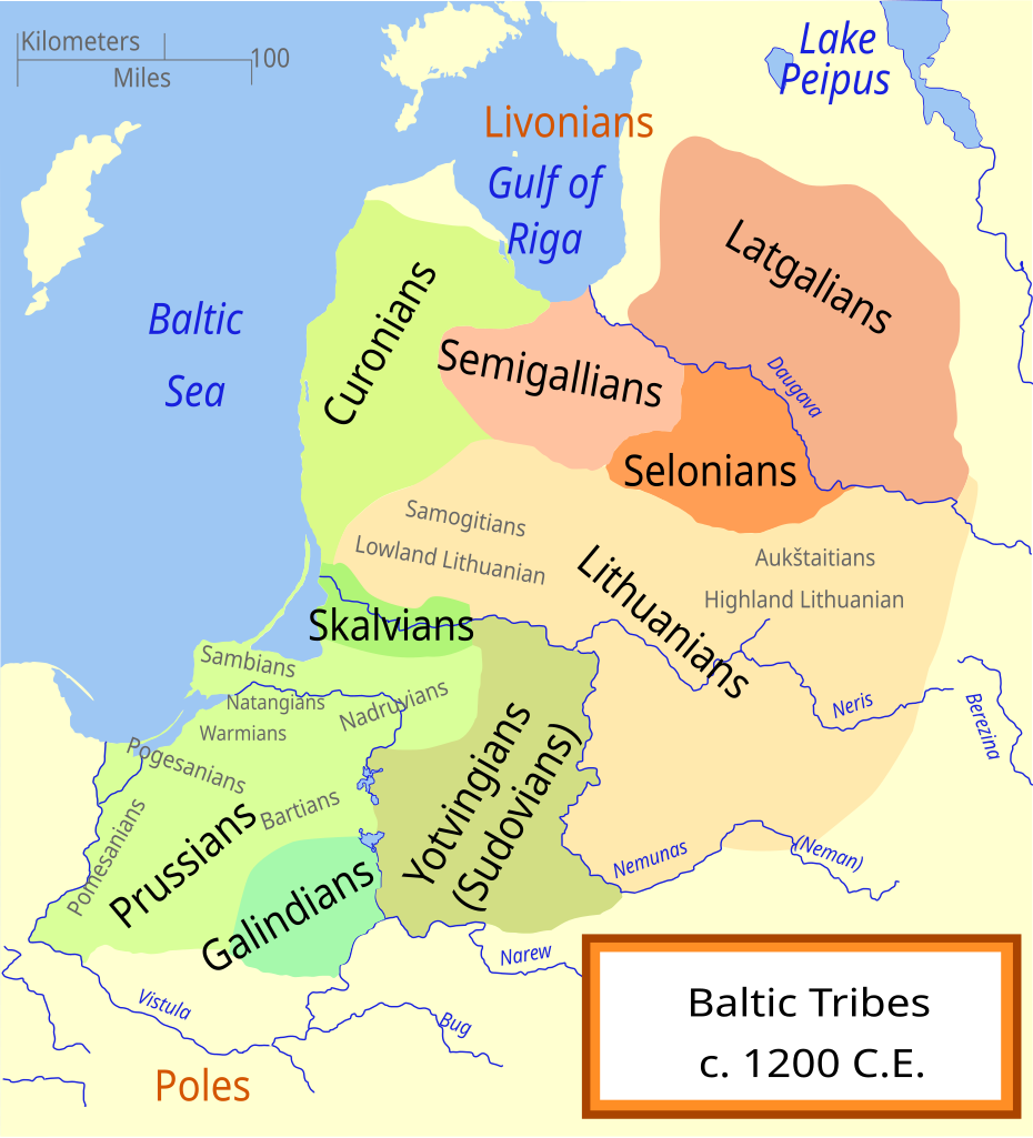
[] Català: Un mapa de les tribus bàltiques, cap al 1200 d.C. Els bàltics orientals es mostren en tons marrons mentre que els bàltics occidentals es mostren en verd. Els límits són aproximats. Aquest mapa utilitza una projecció de Mercator. Deutsch: Karte der baltischen Stämme um 1200. Ostbalten in Braun, Westbalten in Grün. Ungefähre Grenzen. English: A map of the Baltic Tribes, about 1200 AD. The Eastern Balts are shown in brown hues while the Western Balts are shown in green. The boundaries are approximate. This map uses a Mercator projection. Español: Mapa de las tribus bálticas, alrededor de 1200 d.C. Los bálticos orientales se muestran en tonos marrones, mientras que los bálticos occidentales están mostrados en verde. Las fronteras son aproximadas. Français : Une carte des peuples baltes vers 1200. Les Baltes orientaux sont représentés en marron, tandis que les Baltes occidentaux sont représentés en vert. Les frontières sont approximatives. Latviešu: Baltu cilšu apdzīvotās teritorijas aptuveni 12-13 gs. mijā. Robežas ir aptuvenas. Rietumbalti kartē iezīmēt zaļganos toņos, austrumbalti - brūnganos. Lietuvių: Baltų genčių teritorija apie 1200 metus. Vakarų baltų teritorija yra nuspalvinta žaliomis, rytų - rusvomis spalvomis. Teritorijos yra apytikslės. Magyar: A balti törzsek területei 1200 körül. A keleti-balt törzseket barnás, a nyugati-baltokat zöldes színek jelölik. Nederlands: De Baltische volkeren ca. 1200 AD. Oostbalten in bruin, Westbalten in groen. Grenzen zijn bij benadering. Polski: Mapa ukazuje plemiona Bałtyjskie, około 1200 n.e. Wschodni Bałtowie są w odcieniach brązu, zachodni - zieleni. Беларуская: Мапа балтыйскіх плямёнаў у канцы 12 — пачату 13 стагодзьдзяў. Тэрыторыі ўсходніх балтаў афарбаваныя ў карычневых адценьнях, у той жа час тэрыторыі заходніх балтаў афарбаваныя ў адценьні зялёнага колеру. Межы ўказаныя прыблізна. Русский: Карта балтийских племен в конце 12 – начале 13 веков. Территории восточных балтов окрашены в коричневых оттенках, в то время как территории западных балтов окрашены в оттенках зеленого цвета. Границы указаны приблизительно. Українська: Карта балтійських племен 1200 року. Території східних балтів фарбовані коричневими відтінтакми, а території західних балтів - зеленими. Межі народів вказані умовно. |
||
| Date | (originally: 2007-01) | ||
| Source |
Based on Baltic Tribes c 1200.svg, this is a version with multilang support (switch) in SVG file format. Selected compatible font and changed text deformation from original file. It was duplicated from original Baltic Tribes c 1200.svg to keep original font-size and text effects (deformations) |
||
| Author | Manlleus (original from Baltic Tribes c 1200.svg, MapMaster) | ||
| Other versions |
Other related versions:[]
|
||
| SVG development |
.svg&lang=ca)
.svg&lang=en)


.svg)

.svg)


.svg&action=edit§ion=1)
.svg)
|
This SVG file contains embedded text that can be translated into your language, using any capable SVG editor, text editor or the SVG Translate tool. For more information see: About translating SVG files. |
.svg)
This file is translated using SVG <switch> elements. All translations are stored in the same file! Learn more.
For most Wikipedia projects, you can embed the file normally (without a To translate the text into your language, you can use the SVG Translate tool. Alternatively, you can download the file to your computer, add your translations using whatever software you're familiar with, and re-upload it with the same name. You will find help in Graphics Lab if you're not sure how to do this. |
Licensing
[edit].svg&action=edit§ion=2)
- You are free:
- to share – to copy, distribute and transmit the work
- to remix – to adapt the work
- Under the following conditions:
- attribution – You must give appropriate credit, provide a link to the license, and indicate if changes were made. You may do so in any reasonable manner, but not in any way that suggests the licensor endorses you or your use.
- share alike – If you remix, transform, or build upon the material, you must distribute your contributions under the same or compatible license as the original.
File history
Click on a date/time to view the file as it appeared at that time.
| Date/Time | Thumbnail | Dimensions | User | Comment | |
|---|---|---|---|---|---|
| current | 07:01, 4 April 2024 | | 988 × 1,088 (358 KB) | Haziq Faruqi (talk | contribs) | File uploaded using svgtranslate tool (https://svgtranslate.toolforge.org/). Added translation for ms. |
| 17:33, 1 February 2024 |  | 988 × 1,088 (325 KB) | Manlleus (talk | contribs) | File uploaded using svgtranslate tool (https://svgtranslate.toolforge.org/). Added translation for ca. | |
| 17:16, 1 February 2024 |  | 988 × 1,088 (264 KB) | Manlleus (talk | contribs) | corrected font size | |
| 17:00, 1 February 2024 |  | 988 × 1,088 (261 KB) | Manlleus (talk | contribs) | Uploaded a work by Own work based on: from Own work based on: a map by Marija Gimbutas, published in The Balts (1963) LCC 63018018. Available at Vaidilute.com (page 23 "Fig. 1. Baltic tribes and provinces c. A.D. 1200" archive). In addition to Gimbutas, other maps were also consulted: with UploadWizard |
You cannot overwrite this file.
File usage on Commons
The following 19 pages use this file:
- User:Magog the Ogre/Multilingual legend/2024 April 1-5
- User:Magog the Ogre/Multilingual legend/2024 February 1-4
- File:Balten 1200.svg
- File:Balti ap 13.gs.svg
- File:Baltic Tribes c 1200-fr.svg
- File:Baltic Tribes c 1200-hu.svg
- File:Baltic Tribes c 1200-uk.svg
- File:Baltic Tribes c 1200.svg
- File:Baltic Tribes c 1200PL..svg
- File:Baltic Tribes c 1200RU.svg
- File:Baltic Tribes c 1200 ce.svg
- File:Baltic Tribes c 1200 en(multilang).svg
- File:Baltic Tribes c 1200 es.svg
- File:Baltic Tribes ca 1200 AD (et).svg
- File:Baltische Stämme um 1200.png
- File:Baltische Stämme um 1200.svg
- File:Baltų gentys 12-as amžius.svg
- File:Tribu baltiche 1200.png
- Template:Other versions/Baltic Tribes ca 1200 AD
File usage on other wikis
The following other wikis use this file:
.svg&oldid=865770351)