File:Baltic Tribes c 1200RU.svg
Jump to navigation
Jump to search

Size of this PNG preview of this SVG file: 542 × 600 pixels. Other resolutions: 217 × 240 pixels | 434 × 480 pixels | 694 × 768 pixels | 925 × 1,024 pixels | 1,850 × 2,048 pixels | 768 × 850 pixels.
Original file (SVG file, nominally 768 × 850 pixels, file size: 767 KB)
Captions
Captions
Add a one-line explanation of what this file represents
Summary
[edit]| Description |
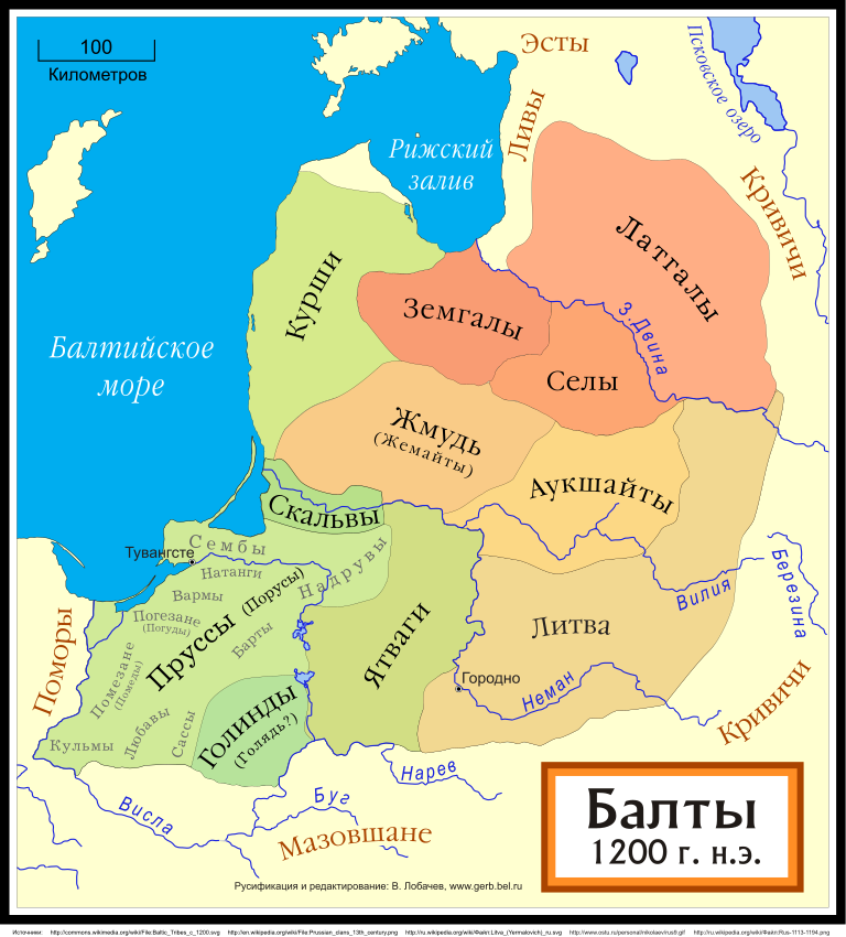
[] Català: Un mapa de les tribus bàltiques, cap al 1200 d.C. Els bàltics orientals es mostren en tons marrons mentre que els bàltics occidentals es mostren en verd. Els límits són aproximats. Aquest mapa utilitza una projecció de Mercator. Deutsch: Karte der baltischen Stämme um 1200. Ostbalten in Braun, Westbalten in Grün. Ungefähre Grenzen. English: A map of the Baltic Tribes, about 1200 AD. The Eastern Balts are shown in brown hues while the Western Balts are shown in green. The boundaries are approximate. This map uses a Mercator projection. Español: Mapa de las tribus bálticas, alrededor de 1200 d.C. Los bálticos orientales se muestran en tonos marrones, mientras que los bálticos occidentales están mostrados en verde. Las fronteras son aproximadas. Français : Une carte des peuples baltes vers 1200. Les Baltes orientaux sont représentés en marron, tandis que les Baltes occidentaux sont représentés en vert. Les frontières sont approximatives. Latviešu: Baltu cilšu apdzīvotās teritorijas aptuveni 12-13 gs. mijā. Robežas ir aptuvenas. Rietumbalti kartē iezīmēt zaļganos toņos, austrumbalti - brūnganos. Lietuvių: Baltų genčių teritorija apie 1200 metus. Vakarų baltų teritorija yra nuspalvinta žaliomis, rytų - rusvomis spalvomis. Teritorijos yra apytikslės. Magyar: A balti törzsek területei 1200 körül. A keleti-balt törzseket barnás, a nyugati-baltokat zöldes színek jelölik. Nederlands: De Baltische volkeren ca. 1200 AD. Oostbalten in bruin, Westbalten in groen. Grenzen zijn bij benadering. Polski: Mapa ukazuje plemiona Bałtyjskie, około 1200 n.e. Wschodni Bałtowie są w odcieniach brązu, zachodni - zieleni. Беларуская: Мапа балтыйскіх плямёнаў у канцы 12 — пачату 13 стагодзьдзяў. Тэрыторыі ўсходніх балтаў афарбаваныя ў карычневых адценьнях, у той жа час тэрыторыі заходніх балтаў афарбаваныя ў адценьні зялёнага колеру. Межы ўказаныя прыблізна. Русский: Карта балтийских племен в конце 12 – начале 13 веков. Территории восточных балтов окрашены в коричневых оттенках, в то время как территории западных балтов окрашены в оттенках зеленого цвета. Границы указаны приблизительно. Українська: Карта балтійських племен 1200 року. Території східних балтів фарбовані коричневими відтінтакми, а території західних балтів - зеленими. Межі народів вказані умовно. |
||
| Date | |||
| Source | File:Baltic Tribes c 1200.svg | ||
| Author | User:MapMaster, производная версия Лобачев Владимир | ||
| Other versions |
[]
|
||
| SVG development | This map was created with Adobe Illustrator. |
.svg&lang=ca)


.svg)

.svg)


Licensing
[edit]

|
Permission is granted to copy, distribute and/or modify this document under the terms of the GNU Free Documentation License, Version 1.2 or any later version published by the Free Software Foundation; with no Invariant Sections, no Front-Cover Texts, and no Back-Cover Texts. A copy of the license is included in the section entitled GNU Free Documentation License. |
File history
Click on a date/time to view the file as it appeared at that time.
| Date/Time | Thumbnail | Dimensions | User | Comment | |
|---|---|---|---|---|---|
| current | 03:11, 15 June 2023 | | 768 × 850 (767 KB) | Mantulis87 (talk | contribs) | Reverted to version as of 23:17, 22 December 2009 (UTC) |
| 03:09, 15 June 2023 |  | 1,134 × 1,594 (779 KB) | Mantulis87 (talk | contribs) | Reverted to version as of 19:25, 14 December 2009 (UTC) | |
| 23:17, 22 December 2009 |  | 768 × 850 (767 KB) | Лобачев Владимир (talk | contribs) | Балты в начале 13 века. | |
| 03:31, 15 December 2009 |  | 755 × 825 (693 KB) | Лобачев Владимир (talk | contribs) | {{Information |Description=Карта балтийских народов. Зеленым цветом показаны западные балты, жедтым - восточные. Границы приблизительные. Первоисточни | |
| 19:33, 14 December 2009 |  | 755 × 825 (672 KB) | Лобачев Владимир (talk | contribs) | ||
| 19:25, 14 December 2009 |  | 1,134 × 1,594 (779 KB) | Лобачев Владимир (talk | contribs) | {{Information |Description={{ru|1=Карты балтийских народов в 1200 году (начало 13 века).}} |Source={{own}} |Author=Лобачев Владимир |Date=2009-12-14 |Permission= |
You cannot overwrite this file.
File usage on Commons
The following 18 pages use this file:
- User:Magog the Ogre/Multilingual legend/2023 June 11-20
- File:Balten 1200.svg
- File:Balti ap 13.gs.svg
- File:Baltic Tribes c 1200-fr.svg
- File:Baltic Tribes c 1200-hu.svg
- File:Baltic Tribes c 1200-uk.svg
- File:Baltic Tribes c 1200.svg
- File:Baltic Tribes c 1200PL..svg
- File:Baltic Tribes c 1200RU.svg
- File:Baltic Tribes c 1200 ce.svg
- File:Baltic Tribes c 1200 en(multilang).svg
- File:Baltic Tribes c 1200 es.svg
- File:Baltic Tribes ca 1200 AD (et).svg
- File:Baltische Stämme um 1200.png
- File:Baltische Stämme um 1200.svg
- File:Baltų gentys 12-as amžius.svg
- File:Tribu baltiche 1200.png
- Template:Other versions/Baltic Tribes ca 1200 AD
File usage on other wikis
The following other wikis use this file:
- Usage on ba.wikipedia.org
- Usage on ce.wikipedia.org
- Usage on cv.wikipedia.org
- Usage on ru.wikipedia.org
- Пруссы
- Курши
- Ятвяги
- Литовский язык
- Латышский язык
- Литовцы
- Жемайты
- Прусский язык
- История Литвы
- Балты
- Земгалы
- Селы
- Земгале
- Куршский язык
- Земгальский язык
- Селонский язык
- Ятвягия
- Скальвы
- Ливонский крестовый поход
- Участник:AlexPin/Лютичи
- Литва (племена)
- Прусский крестовый поход
- Хроника Ливонии
- Аукштайты
- История Великого княжества Литовского (1219—1295)
- История Калининградской области
- Походы русских князей против Ордена меченосцев
- Скуманд
- Католическая колонизация Прибалтики
- Usage on tt.wikipedia.org
- Usage on www.wikidata.org