File:Balk map.png

Original file (2,532 × 1,332 pixels, file size: 4.75 MB, MIME type: image/png)
Captions
Captions
| Description |
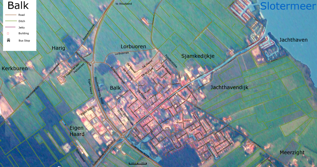
This is a map of Balk Friesland Netherlands. The map is based on a aerial photo taken on 2 September 2004 called file:Balk_20040902_2222.jpg on commons. The picture was clipped, rotated, perspective altered in Gimp. The next layer is water and ditches, the next layer is roads, the next layer is buildings. These layers are hand drawn. Names of streets, scale and legend are on top. Information on names of streets, and locations of buildings was derived from Google Maps 2009. Scale is roughly 1:5000 when displayed at 75 dpi or 0.7 pixels/meter. North is to the top of the map. The Slotermeer is the lake to the north east. It is connected to a canal (de Lutz) through the town of Balk. Other hamlets or localities on this map are Harig, Kerkburen, Lorbuoren (lorburen), Meerzight, Jachthaven, Sjankedijkje, Jachthavendijk, and Eigen Haard. Some names may be in old 19th century spelling. A Stellingwerf Straat, Barent Fokkesstraat, Bauke, Bedrijventerrein Stikke, Benjamin Steegengastjitte, Bloemstraat, Boersma Bogermanstraat, Bosmastrjitte, De Binge, De Dammen, De Dobbe, De Eker, De Finne, De Greide, De Mieden, De Oper, De Timpe, De Warren, De Weind, De Wurdze, DokterWestrastrjitte, Douwe Aukesstraat, Dubbelstraat, Eigen Haard, Erasmusstraat, Foarset, Gaaikemastraat, Gansfortstraat, H Gabesstrijtte, H Gorterstraat, Harichsterdyk, Harichsterstikke, Heechkamp, Hielkemastrjitte, Hoite Detmarstrjitte, Houtdijk, It Bjirkenbosk, It Heech, It Hoefizer, J Bremmer strjitte, J Meineszleane, Jachthavendijk, Jachthavendyk, Jachtlustweg, Jelle Wissesstrjitte, Jogchem de Ruiterstrjitte, Julianastraat, Keamerlanswei, Kerkburen, Klaas van Houtstrjitte, Lapidothstrjitte, Lijnbaen, Lorbuoren, Lorbuorren, Lubertus van Beekstrjitte, Ludgerusstraat, Lutswal, Lytse Side, M Simonszstraat, Markant, Meerweg, Meerzight, Meester C J Trompstraat, Munnikeleane, Pypsterstikke, Raadhuisstraat, Sate Steenbergenstrjitte, Schoolstraat, Schwartzenbergstrjitte, Siemen de Jong strjitte, Sjamkedijkje, Sleatemar, Slotermeer, Sportfjild, Stinsenwei, Sudergoawei N359, Sudersewei N359, Tjalke de Boerstrjitte, Tribune, Tsjamkedykje, Tsjerk Hiddestraat, Tsjerkepaed, Van Heemstrastrjitte, Van Swinderenstraat, W van der Heideplein, Warrensterwei, Welgelegen, Westein, Wikelerdijk, Wilhelminastraat, Willen Barentszstraat, Woudsenderweg N928, Zuidwesthoekstraat, van der Feitzstraat, Balk is een dorp in de provincie Friesland (Nederland). Het is de hoofdplaats van de gemeente Gaasterland-Sloten (Gaasterlân-Sleat), Balk |
| Date | (UTC) |
| Source | |
| Author |
|
| This is a retouched picture, which means that it has been digitally altered from its original version. Modifications: heaps of editting to turn into a map. The original can be viewed here: Balk 20040902 2222.jpg:
|

|
Permission is granted to copy, distribute and/or modify this document under the terms of the GNU Free Documentation License, Version 1.2 or any later version published by the Free Software Foundation; with no Invariant Sections, no Front-Cover Texts, and no Back-Cover Texts. A copy of the license is included in the section entitled GNU Free Documentation License. |
| This file is licensed under the Creative Commons Attribution-Share Alike 3.0 Unported license. | ||
| ||
| This licensing tag was added to this file as part of the GFDL licensing update. |
Original upload log
[edit]
This image is a derivative work of the following images:
- File:Balk_20040902_2222.jpg licensed with GFDL
- 2007-03-07T19:02:17Z SieBot 2032x1354 (408622 Bytes) {{Information |Description=Balk is een dorp in de provincie Friesland (Nederland). Het is de hoofdplaats van de gemeente Gaasterland-Sloten (Gaasterlân-Sleat), [[:nl:Categorie:Luchtfoto|Balk]] |Source=Originally from [ht
Uploaded with derivativeFX
File history
Click on a date/time to view the file as it appeared at that time.
| Date/Time | Thumbnail | Dimensions | User | Comment | |
|---|---|---|---|---|---|
| current | 13:14, 5 June 2009 | | 2,532 × 1,332 (4.75 MB) | Graeme Bartlett (talk | contribs) | {{Information |Description=This is a map of Balk or Bauke Friesland. The map is based on a aerial photo taken on 2 September 2004 called Balk_20040902_2222.jpg on commons. The picture was clipped, rotated, perspective altered in Gimp. The next layer is |
You cannot overwrite this file.
File usage on Commons
There are no pages that use this file.
File usage on other wikis
The following other wikis use this file:
- Usage on en.wikipedia.org
- Usage on fr.wikipedia.org
- Usage on uk.wikipedia.org