File:Balch Creek.png
Jump to navigation
Jump to search

Size of this preview: 800 × 400 pixels. Other resolutions: 320 × 160 pixels | 640 × 320 pixels | 1,000 × 500 pixels.
Original file (1,000 × 500 pixels, file size: 1.03 MB, MIME type: image/png)
Captions
Captions
Add a one-line explanation of what this file represents
Summary
[edit]
| Description |
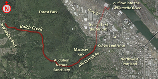
English: Map shows the course of Balch Creek, tributary of the Willamette River, through Forest Park. At the lower end of MacLeay Park, it enters an underground culvert for the last length of its journey to the river. |
| Date | 5-10-2008 |
| Source | Aerial photograph from the US Geological Survey. I annotated the map myself using various sources and my original contributions are hereby released into the public domain. |
| Author | USGS and User:Northwest-historian |
Licensing
[edit]
This image is in the public domain in the United States because it only contains materials that originally came from the United States Geological Survey, an agency of the United States Department of the Interior. For more information, see the official USGS copyright policy.
|
Original upload log
[edit]
| date/time | username | resolution | size | edit summary |
|---|---|---|---|---|
| 2008-05-10T19:22:39Z | User:Northwest-historian | 1000×500 | 1.03Gb | fix Audubon misspelling |
| 2008-05-10T10:15:43Z | User:Northwest-historian | 1000×500 | 1.28Gb | sharpen slightly |
| 2008-05-10T10:11:31Z | User:Northwest-historian | 1000×500 | 1.18Gb | {{Information |Description={{en|1=Map shows the course of Balch Creek, tributary of the Willamette River, through Forest Park. At the lower end of MacLeay Park, it enters an underground culvert for the last length of its journey to the river.}} |Source=Aerial phot |
File history
Click on a date/time to view the file as it appeared at that time.
| Date/Time | Thumbnail | Dimensions | User | Comment | |
|---|---|---|---|---|---|
| current | 15:42, 13 August 2009 | | 1,000 × 500 (1.03 MB) | BetacommandBot (talk | contribs) | move approved by: User:Aboutmovies This image was moved from File:Balc Creek.png == {{int:filedesc}} == {{Information |Description=Map shows the course of Balch Creek, tributary of the Willamette River, through Forest Park. At the lower end of |
You cannot overwrite this file.
File usage on Commons
There are no pages that use this file.