File:Baja California hurricane tracks.png
Jump to navigation
Jump to search

Size of this preview: 800 × 600 pixels. Other resolutions: 320 × 240 pixels | 640 × 480 pixels | 1,024 × 768 pixels | 1,280 × 960 pixels | 2,000 × 1,500 pixels.
Original file (2,000 × 1,500 pixels, file size: 2.45 MB, MIME type: image/png)
Captions
Captions
Baja California
Summary
[edit]
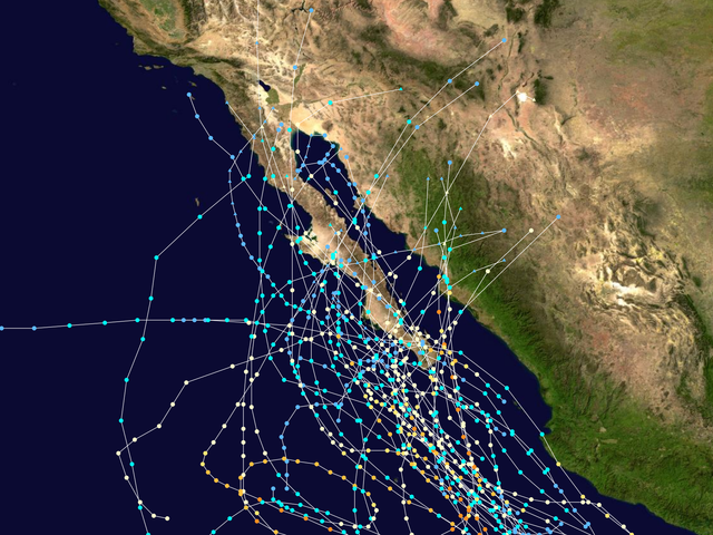
This map shows the tracks of all Tropical cyclones with effects on the Baja California Peninsula. Uses the color scheme from the Saffir-Simpson Hurricane Scale.
Licensing
[edit]
Created using User:jdorje/Tracks. Background image from Image:Whole world - land and oceans.jpg (NASA). Tracking data from the w:National Hurricane Center. [1] archive copy at the Wayback Machine
| I, the copyright holder of this work, release this work into the public domain. This applies worldwide. In some countries this may not be legally possible; if so: I grant anyone the right to use this work for any purpose, without any conditions, unless such conditions are required by law. |
File history
Click on a date/time to view the file as it appeared at that time.
| Date/Time | Thumbnail | Dimensions | User | Comment | |
|---|---|---|---|---|---|
| current | 14:23, 24 December 2006 | | 2,000 × 1,500 (2.45 MB) | Nilfanion (talk | contribs) | == Summary == This map shows the tracks of all {{w|Tropical cyclones}} with effects on the {{w|Baja California Peninsula}}. Uses the color scheme from the {{w|Saffir-Simpson Hurricane Scale}}. == Licensing == Created using {{w|User:jdorje/Tracks}}. Back |
You cannot overwrite this file.
File usage on Commons
There are no pages that use this file.
File usage on other wikis
The following other wikis use this file:
- Usage on en.wikipedia.org
- Portal:Tropical cyclones/Did you know/Archive
- List of Baja California Peninsula hurricanes
- Portal:Tropical cyclones/Featured article/List of Baja California hurricanes
- User:TonyTheTiger/List of the Day/Nominees/200806
- User:TonyTheTiger/List of the Day/Nominees/200807
- User:TonyTheTiger/List of the Day/Nominees/200808