File:Baja California - NASA Earth Observatory.jpg

Original file (12,000 × 10,000 pixels, file size: 7.24 MB, MIME type: image/jpeg)
Captions
Captions
Summary
[edit]
| Warning | The original file is very high-resolution. It might not load properly or could cause your browser to freeze when opened at full size. |
|---|
| Description |
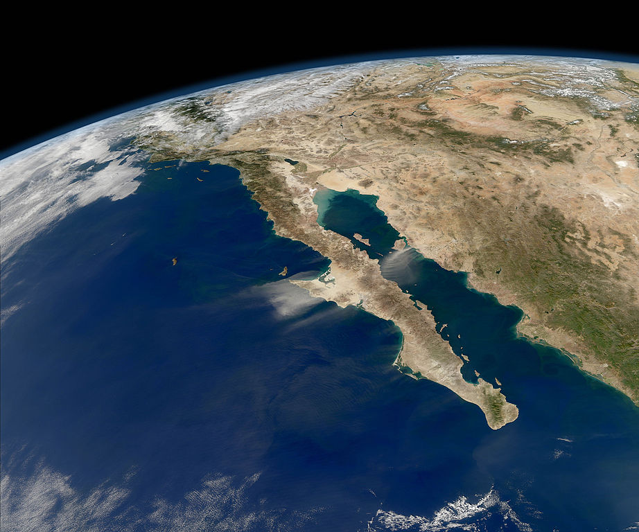
To download the full resolution go to: earthobservatory.nasa.gov/IOTD/view.php?id=76891&src=... Late November 2011 offered mostly cloud-free skies and a compelling view of the entire length of Baja California and the Pacific coast of Mexico. In the midst of the clarity, strong northeasterly winds stirred up dust storms on the mainland and the peninsula. The natural-color images required to make this oblique view were acquired on November 27, 2011, by the Moderate Resolution Imaging Spectroradiometer (MODIS) on NASA’s Aqua satellite. The Ocean Color Team at NASA Goddard processes images like this to help assess the presence of sediment and plankton in the sea. Dust storms interfere with that processing, as the sandy aerosols block much of the incoming sunlight and the outgoing, reflected light. Dust storms can disturb human activity on land, but once they blow out over the Gulf of California and Pacific Ocean, they help fertilize the waters with nutrients that promote phytoplankton blooms. In winter, the waters around Baja are often full of whales, as the largest creatures in the sea often eat the smallest plankton. Researchers at the University of Wisconsin put the storm to a practical use. They are working to calibrate measurements on two instruments on the GOES weather satellites, and the dust storm provided a nice event for comparison. NASA image by Norman Kuring, Ocean Color Team. Caption by Mike Carlowicz, with assistance from Norman Kuring. The Earth Observatory's mission is to share with the public the images, stories, and discoveries about climate and the environment that emerge from NASA research, including its satellite missions, in-the-field research, and climate models. Like us on Facebook Follow us on Twitter Add us to your circles on Google+ |
| Date | |
| Source | Baja California |
| Author | NASA's Earth Observatory |
| Camera location | | View this and other nearby images on: OpenStreetMap |
|---|
Licensing
[edit]
- You are free:
- to share – to copy, distribute and transmit the work
- to remix – to adapt the work
- Under the following conditions:
- attribution – You must give appropriate credit, provide a link to the license, and indicate if changes were made. You may do so in any reasonable manner, but not in any way that suggests the licensor endorses you or your use.
| This image was originally posted to Flickr by NASA Earth Observatory at https://www.flickr.com/photos/68824346@N02/6660030421. It was reviewed on 2 July 2012 by FlickreviewR and was confirmed to be licensed under the terms of the cc-by-2.0. |
File history
Click on a date/time to view the file as it appeared at that time.
| Date/Time | Thumbnail | Dimensions | User | Comment | |
|---|---|---|---|---|---|
| current | 23:17, 5 April 2016 | | 12,000 × 10,000 (7.24 MB) | Ras67 (talk | contribs) | high resolution original |
| 17:14, 2 July 2012 |  | 720 × 480 (164 KB) | Dzlinker (talk | contribs) | == {{int:filedesc}} == {{Information |Description=To download the full resolution go to: [http://earthobservatory.nasa.gov/IOTD/view.php?id=76891&src=flickr earthobservatory.nasa.gov/IOTD/view.php?id=76891&src=...] Late November 2011 offered mostly cl... |
You cannot overwrite this file.
File usage on Commons
The following page uses this file: