File:Baist's real estate atlas of surveys of Denver, Col. (Plate 31) - DPLA - 676a034ed13a2751b0cb46de108c5752.jpg
Jump to navigation
Jump to search
Size of this preview: 800 × 555 pixels. Other resolutions: 320 × 222 pixels | 640 × 444 pixels | 1,024 × 711 pixels | 1,280 × 888 pixels | 2,560 × 1,776 pixels | 6,870 × 4,767 pixels.
Original file (6,870 × 4,767 pixels, file size: 5.64 MB, MIME type: image/jpeg)
Captions
Captions
Add a one-line explanation of what this file represents
Summary
[edit]This file was uploaded by the Digital Public Library of America, and the following item metadata was created by the contributing institution's staff.
Note: this data is being maintained by an automated bot, synced with the source data.
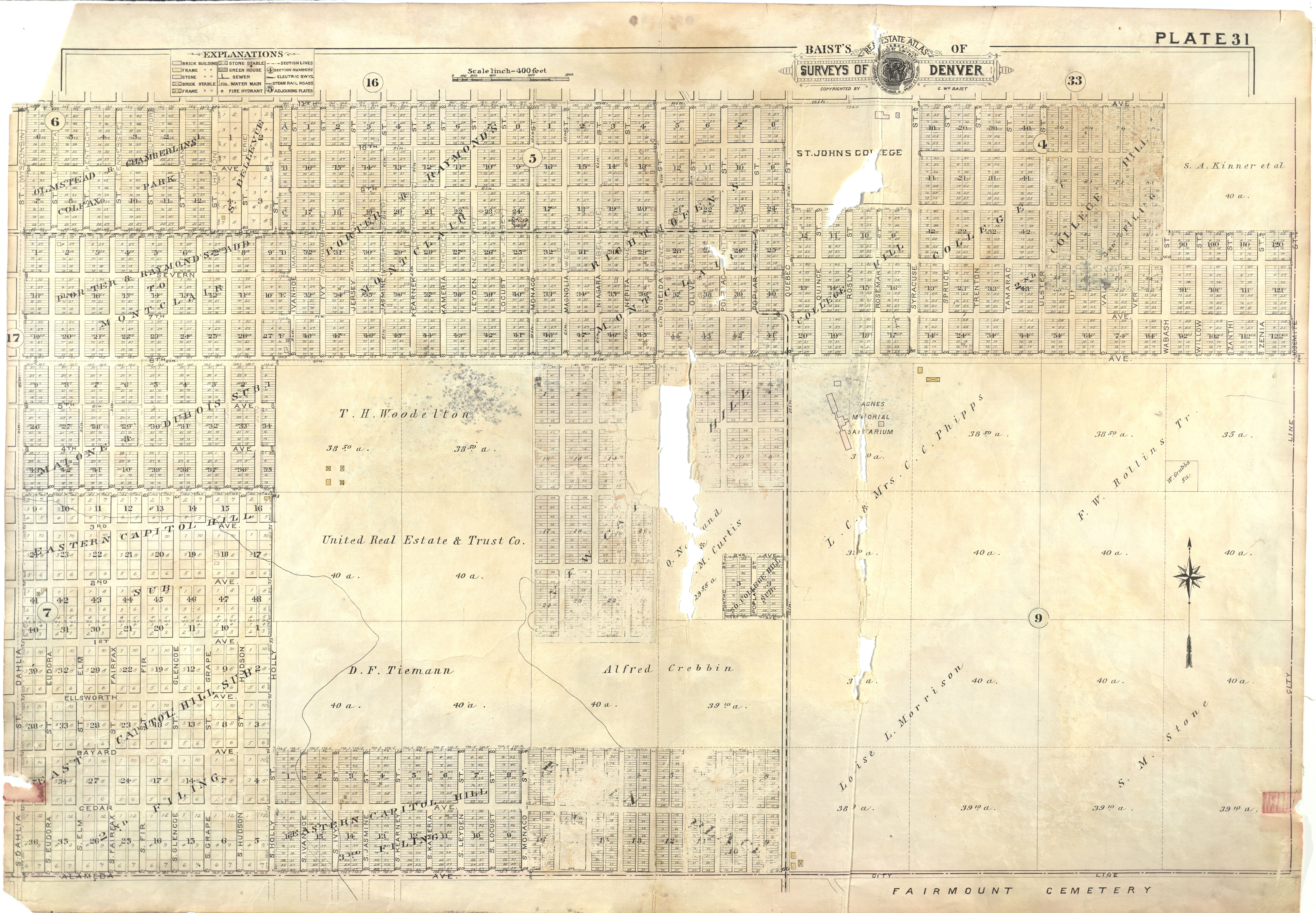
| Description | Historical map of Denver, Colorado, Scale. 1 in. to 300 feet | ||||||||||||||||||||
| Title | Baist's real estate atlas of surveys of Denver, Col. (Plate 31) | ||||||||||||||||||||
| Institution |
|
||||||||||||||||||||
| Subject | real property, Denver | ||||||||||||||||||||
| Date | |||||||||||||||||||||
| Source |
Plains to Peaks Collective |
||||||||||||||||||||
| Author |
Baist, G. Wm. (George William), 1859-1927 |
||||||||||||||||||||
| Permission (Reusing this file) |
Copyright determination made by Denver Public Library (Q5259775) using RightsStatements.org
|
||||||||||||||||||||
| Partnership |
|
||||||||||||||||||||


_-_DPLA_-_676a034ed13a2751b0cb46de108c5752.jpg&action=edit§ion=1)
File history
Click on a date/time to view the file as it appeared at that time.
| Date/Time | Thumbnail | Dimensions | User | Comment | |
|---|---|---|---|---|---|
| current | 19:58, 31 August 2023 | | 6,870 × 4,767 (5.64 MB) | DPLA bot (talk | contribs) | Uploading DPLA ID "676a034ed13a2751b0cb46de108c5752". |
You cannot overwrite this file.
File usage on Commons
There are no pages that use this file.
_-_DPLA_-_676a034ed13a2751b0cb46de108c5752.jpg&oldid=834957070)