File:BahnhofAesch, OSM map 2022.png
Jump to navigation
Jump to search

Size of this preview: 800 × 448 pixels. Other resolutions: 320 × 179 pixels | 640 × 358 pixels | 943 × 528 pixels.
Original file (943 × 528 pixels, file size: 325 KB, MIME type: image/png)
Captions
Captions
Add a one-line explanation of what this file represents
Summary
[edit]
| Description |
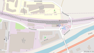
English: Aesch railway station: map of the station in Aesch, canton of Basel-Land, Switzerland. Top of the map is East. North is at 260°.
 |
| Date | |
| Source | OpenStreetMap |
| Author | OpenStreetMap contributors |
| Object location | | View this and other nearby images on: OpenStreetMap |
|---|
Licensing
[edit]
| This work contains information from OpenStreetMap, which is made available under the Open Database License (ODbL).
The ODbL does not require any particular license for maps produced from ODbL data. Prior to 1 August 2020, map tiles produced by the OpenStreetMap Foundation were licensed under the CC-BY-SA-2.0 license. Maps produced by other people may be subject to other licences. |
File history
Click on a date/time to view the file as it appeared at that time.
| Date/Time | Thumbnail | Dimensions | User | Comment | |
|---|---|---|---|---|---|
| current | 20:01, 1 November 2022 | | 943 × 528 (325 KB) | Enhancing999 (talk | contribs) | Cropped 15 % horizontally, 54 % vertically, rotated -100° using CropTool with precise mode. |
| 19:56, 1 November 2022 |  | 1,104 × 1,148 (462 KB) | Enhancing999 (talk | contribs) | Uploaded a work by insert from insert with UploadWizard |
You cannot overwrite this file.
File usage on Commons
There are no pages that use this file.
File usage on other wikis
The following other wikis use this file:
- Usage on en.wikipedia.org
- Usage on eo.wikipedia.org