File:Babilonia de Hammurabi-ES.svg
Jump to navigation
Jump to search

Size of this PNG preview of this SVG file: 687 × 599 pixels. Other resolutions: 275 × 240 pixels | 550 × 480 pixels | 880 × 768 pixels | 1,174 × 1,024 pixels | 2,348 × 2,048 pixels | 705 × 615 pixels.
Original file (SVG file, nominally 705 × 615 pixels, file size: 304 KB)
Captions
Captions
Add a one-line explanation of what this file represents
Summary
[edit]| Description |
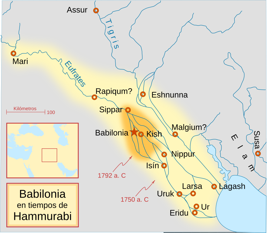
English: A locator map of Hammurabi's Babylonia, showing the Babylonian territory upon his ascension in 1792 BC and upon his death in 1750 BC. The river courses and coastline are those of that time period -- in general, they are not the modern rivers or coastlines. This is a Mercator projection, with north in its usual position.
There is some question to what degree the cities of Nineveh, Tuttul, and Assur were under Babylonian authority. While in his introduction to his code of laws, Hammurabi claims lordship over these cities, Roaf does not include any of these in his map, upon which this map is based, and Chevalas states that "Assur and Nineveh were held for a very few years" (p. 155). Therefore, I have not included them as under Hammurabi's control in 1750 BC.
Español: Mapa de la Babilonia de Hammurabi, mostrando el territorio entre su ascenso en 1792 a. C. y su muerte en 1750 a. C. La linea de costa y los cursos de los ríos son los de ese período. El norte se encuentra en su posición usual.
Existen algunas dudas sobre si las ciudades de Nínive, Tttul y Asur estuvieron bajo la autoridad babilona. Mientras que en la introducción del "código de Hammurabi" se asegura su posesión, Roaf no incluye ninguna de ellas, en cuyo mapa está basado éste. |
| Date | |
| Source | Translation of File:Hammurabi's Babylonia 1.svg |
| Author | Crates |
| Other versions |
[]
|


Licensing
[edit]
I, the copyright holder of this work, hereby publish it under the following licenses:

|
Permission is granted to copy, distribute and/or modify this document under the terms of the GNU Free Documentation License, Version 1.2 or any later version published by the Free Software Foundation; with no Invariant Sections, no Front-Cover Texts, and no Back-Cover Texts. A copy of the license is included in the section entitled GNU Free Documentation License. |
This file is licensed under the Creative Commons Attribution-Share Alike Attribution-Share Alike 4.0 International, 3.0 Unported, 2.5 Generic, 2.0 Generic and 1.0 Generic license.
- You are free:
- to share – to copy, distribute and transmit the work
- to remix – to adapt the work
- Under the following conditions:
- attribution – You must give appropriate credit, provide a link to the license, and indicate if changes were made. You may do so in any reasonable manner, but not in any way that suggests the licensor endorses you or your use.
- share alike – If you remix, transform, or build upon the material, you must distribute your contributions under the same or compatible license as the original.
You may select the license of your choice.
File history
Click on a date/time to view the file as it appeared at that time.
| Date/Time | Thumbnail | Dimensions | User | Comment | |
|---|---|---|---|---|---|
| current | 09:48, 12 March 2017 | | 705 × 615 (304 KB) | Rowanwindwhistler (talk | contribs) | Fake text added. Colours from https://en.wikipedia.org/wiki/Wikipedia:WikiProject_Maps/Conventions http://colorbrewer2.org/#type=sequential&scheme=YlOrBr&n=3 |
| 20:28, 17 January 2009 |  | 661 × 577 (159 KB) | Phirosiberia (talk | contribs) | {{Information |Description={{en|1=A locator map of Hammurabi's Babylonia, showing the Babylonian territory upon his ascension in 1792 BC and upon his death in 1750 BC. The river courses and coastline are those of that time period -- in general, they are n |
You cannot overwrite this file.
File usage on Commons
The following 13 pages use this file:
- File:Babilonia de Hammurabi-ES.svg
- File:Hammurabi's Babylonia-he.svg
- File:Hammurabi's Babylonia 1-ar.svg
- File:Hammurabi's Babylonia 1-hu.svg
- File:Hammurabi's Babylonia 1-tr.svg
- File:Hammurabi's Babylonia 1.svg
- File:Hammurabi's Babylonia CS.svg
- File:Hammurabi's Babylonia Locator Map 1.svg
- File:Hammurabi's Babylonia PL.svg
- File:Hammurabi's Babylonia RU.svg
- File:Hammurabi's Babylonia UA.svg
- File:Hammurabi Babilonia CA.svg
- Template:Other versions/Hammurabi's Babylonia 1
File usage on other wikis
The following other wikis use this file:
- Usage on ca.wikipedia.org
- Usage on es.wikipedia.org
- Usage on eu.wikipedia.org
- Usage on lv.wikipedia.org
- Usage on pt.wikipedia.org