File:Babaçulândia, às margens do reservatório da UHE Estreito, no Rio Tocantins.jpg
Jump to navigation
Jump to search

Size of this preview: 800 × 450 pixels. Other resolutions: 320 × 180 pixels | 640 × 360 pixels | 1,024 × 576 pixels | 1,280 × 719 pixels | 3,334 × 1,874 pixels.
Original file (3,334 × 1,874 pixels, file size: 4.27 MB, MIME type: image/jpeg)
Captions
Captions
Add a one-line explanation of what this file represents
Summary
[edit]
| Description |
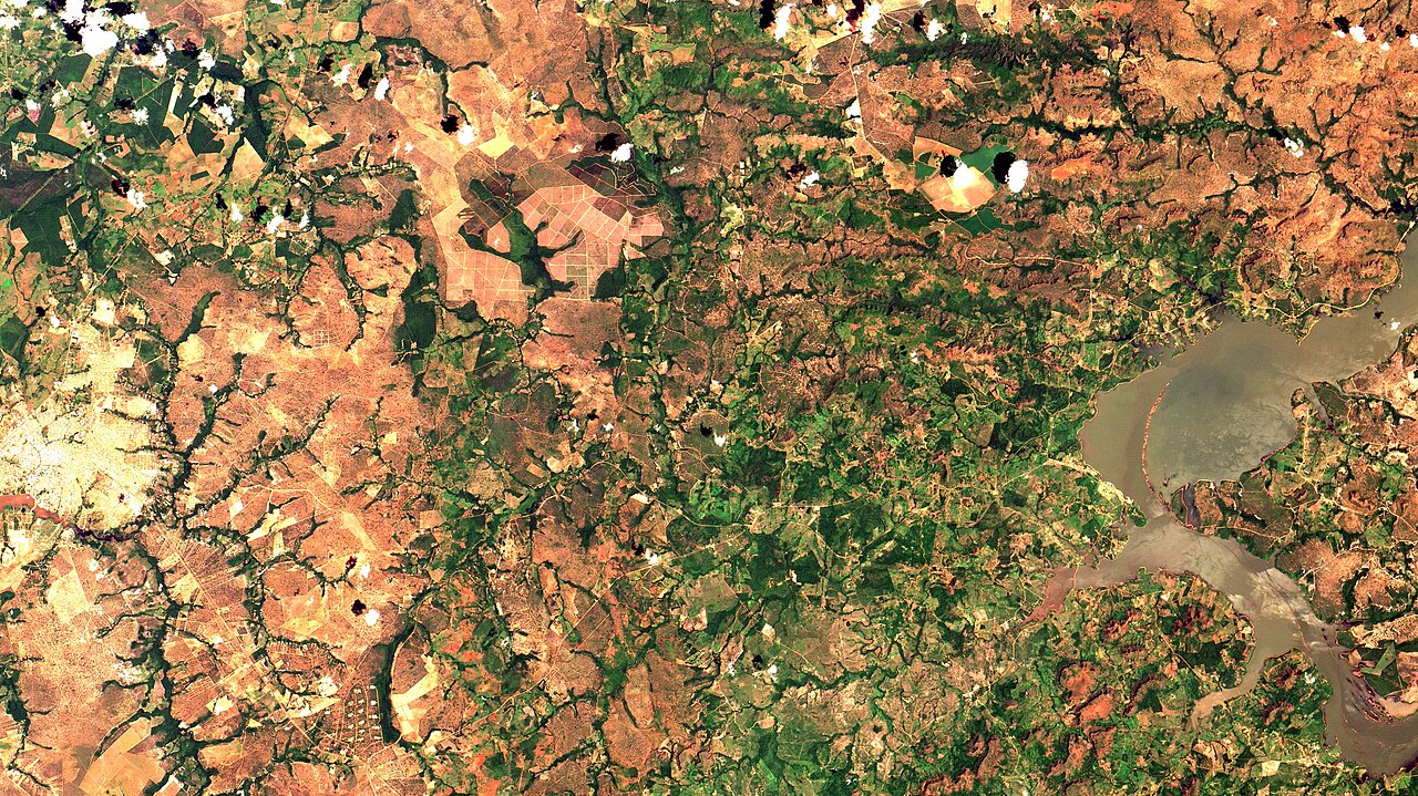
English: Babaçulândia, às margens do reservatório da UHE Estreito, no Rio Tocantins (à direita da imagem). Em branco área urbana, em verde claro pastagens, em verde escuro floresta secundária, em alaranjado solo exposto, que nas chapadas, embaixo, à dir. e no topo da imagem, é cerrado / Babaçulândia, on Tocantins River Estreito Hydroelectric reservoir shore (at right of image). Urban area in white, pastures in light green, regrowth-forest in dark green, exposed soil in orange, wich in image bottom, right and top, is savanna.
Imagem / Image CBERS4 MUX Babaçulândia, Tocantins Coordenadas do centro da imagem / Image center: 7°12'38.3"S 47°44'15.9"W Data / Date: 19-12-2018 / 2018-19-12 RGB 765 (cor verdadeira / true color) Cena / Scene: 160 / 108 Autor / Author: Oton Barros (DSR/OBT/INPE) Imagem em HD / HD Image Visite-nos / Visit us: www.dsr.inpe.br |
| Date | |
| Source | https://www.flickr.com/photos/153282474@N02/44588874800/ |
| Author | Coordenação-Geral de Observação da Terra/INPE |
Licensing
[edit]
This file is licensed under the Creative Commons Attribution-Share Alike 2.0 Generic license.
- You are free:
- to share – to copy, distribute and transmit the work
- to remix – to adapt the work
- Under the following conditions:
- attribution – You must give appropriate credit, provide a link to the license, and indicate if changes were made. You may do so in any reasonable manner, but not in any way that suggests the licensor endorses you or your use.
- share alike – If you remix, transform, or build upon the material, you must distribute your contributions under the same or compatible license as the original.
| This image was originally posted to Flickr by Coordenação-Geral de Observação da Terra/INPE at https://flickr.com/photos/153282474@N02/44588874800. It was reviewed on 9 April 2020 by FlickreviewR 2 and was confirmed to be licensed under the terms of the cc-by-sa-2.0. |
File history
Click on a date/time to view the file as it appeared at that time.
| Date/Time | Thumbnail | Dimensions | User | Comment | |
|---|---|---|---|---|---|
| current | 10:14, 9 April 2020 | | 3,334 × 1,874 (4.27 MB) | Jo-Jo Eumerus (talk | contribs) | Uploaded a work by Coordenação-Geral de Observação da Terra/INPE from https://www.flickr.com/photos/153282474@N02/44588874800/ with UploadWizard |
You cannot overwrite this file.
File usage on Commons
The following page uses this file:
.jpg&redirect=no)