File:Baa Atoll.jpg
Jump to navigation
Jump to search

Size of this preview: 602 × 599 pixels. Other resolutions: 241 × 240 pixels | 482 × 480 pixels | 772 × 768 pixels | 1,029 × 1,024 pixels | 2,057 × 2,048 pixels | 2,608 × 2,596 pixels.
Original file (2,608 × 2,596 pixels, file size: 1.04 MB, MIME type: image/jpeg)
Captions
Captions
Add a one-line explanation of what this file represents

|
This file has been superseded by Baa Atoll.png. It is recommended to use the other file. Please note that deleting superseded images requires consent. Reason to use the other file: "A PNG version of this file is now available."
|

|
Summary
[edit]
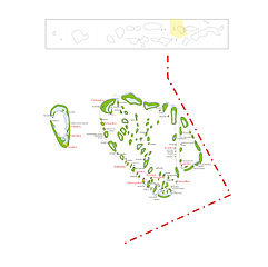
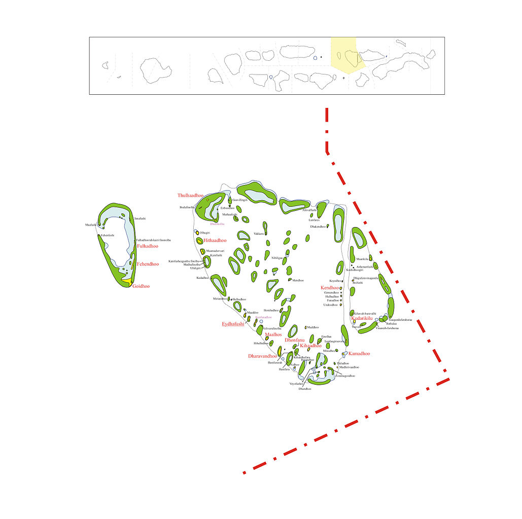
Map of Baa Atoll
Map originally vector'ed by Hassan Waheed, Aabaadhuge of Thinadhoo island.
Note: This section of map was extracted and its text was romanized by Oblivious. Special assitance by Waddey and Zuru
Licensing
[edit]
| This file is licensed under the Creative Commons Attribution-Share Alike 3.0 Unported license. Subject to disclaimers. | ||
| ||
| This licensing tag was added to this file as part of the GFDL licensing update. |

|
Permission is granted to copy, distribute and/or modify this document under the terms of the GNU Free Documentation License, Version 1.2 or any later version published by the Free Software Foundation; with no Invariant Sections, no Front-Cover Texts, and no Back-Cover Texts. A copy of the license is included in the section entitled GNU Free Documentation License. Subject to disclaimers. |
File history
Click on a date/time to view the file as it appeared at that time.
| Date/Time | Thumbnail | Dimensions | User | Comment | |
|---|---|---|---|---|---|
| current | 13:47, 19 March 2014 | | 2,608 × 2,596 (1.04 MB) | Rotatebot (talk | contribs) | Bot: Image rotated by 90° |
| 23:42, 23 November 2005 |  | 2,596 × 2,610 (1.04 MB) | Snowdog (talk | contribs) | Map of Baa Atoll Map originally vector'ed by Hassan Waheed, Aabaadhuge of Thinadhoo island. '''''Note:''' This section of map was extracted and its text was romanized by Oblivious. Special assitance by [[:en:User:Waddey|Waddey |
You cannot overwrite this file.
File usage on Commons
The following page uses this file:
File usage on other wikis
The following other wikis use this file:
- Usage on ceb.wikipedia.org
- Usage on fr.wikipedia.org
- Usage on nl.wikipedia.org
- Ahivaffushi
- Aidhoo
- Anhenunfushi
- Bathalaa (Baa-atol)
- Boifushi
- Dhakendhoo
- Dhandhoo
- Dhigufaruvinagandu
- Dhunikolhu
- Fehenfushi
- Finolhas
- Fonimagoodhoo
- Fulhadhoorah kairi finonolhu
- Gaagandufaruhuraa
- Gaavillingili
- Hanifaru
- Hanifarurah
- Hibalhidhoo
- Hirundhoo
- Horubadhoo
- Kanifusheegaathu finolhu
- Kashidhoogiri
- Kihaadhufaru
- Kihavah-huravalhi
- Kunfunadhoo
- Landaagiraavaru
- Lunfares
- Maaddoo
- Maamaduvvari
- Maarikilu
- Madhirivaadhoo
- Mendhoo
- Milaidhoo
- Miriandhoo
- Muddhoo
- Muthaafushi
- Nibiligaa
- Thiladhoo
- Ufuligiri
- Undoodhoo
- Vakkaru
- Velivarufinolhu
View more global usage of this file.