File:BOS airport diagram.svg
Jump to navigation
Jump to search

Size of this PNG preview of this SVG file: 410 × 420 pixels. Other resolutions: 234 × 240 pixels | 469 × 480 pixels | 750 × 768 pixels | 1,000 × 1,024 pixels | 1,999 × 2,048 pixels.
Original file (SVG file, nominally 410 × 420 pixels, file size: 141 KB)
Captions
Captions
Add a one-line explanation of what this file represents
Summary
[edit]
| Description |
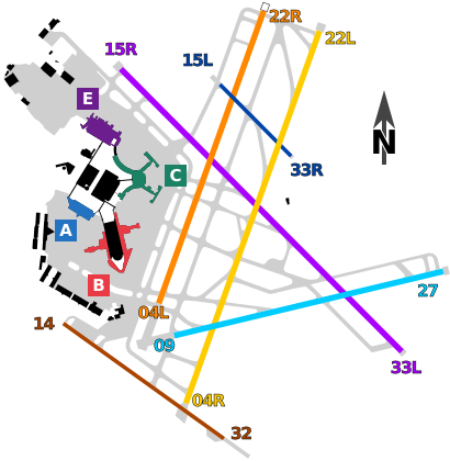
English: Airport diagram of Boston Logan International Airport (BOS). Vector shapes extracted from FAA diagram and colors added. |
| Date | |
| Source | FAA diagram |
| Author | Federal Aviation Administration |
| SVG development | This W3C-invalid diagram was created with Inkscape. This diagram uses embedded text that can be easily translated using a text editor. |
Licensing
[edit]
This work is in the public domain in the United States because it is a work prepared by an officer or employee of the United States Government as part of that person’s official duties under the terms of Title 17, Chapter 1, Section 105 of the US Code.
Note: This only applies to original works of the Federal Government and not to the work of any individual U.S. state, territory, commonwealth, county, municipality, or any other subdivision. This template also does not apply to postage stamp designs published by the United States Postal Service since 1978. (See § 313.6(C)(1) of Compendium of U.S. Copyright Office Practices). It also does not apply to certain US coins; see The US Mint Terms of Use.
|
 | |
| This file has been identified as being free of known restrictions under copyright law, including all related and neighboring rights. | ||
File history
Click on a date/time to view the file as it appeared at that time.
| Date/Time | Thumbnail | Dimensions | User | Comment | |
|---|---|---|---|---|---|
| current | 22:31, 20 August 2017 | | 410 × 420 (141 KB) | Mliu92 (talk | contribs) | User created page with UploadWizard |
You cannot overwrite this file.
File usage on Commons
The following 6 pages use this file:
- User:Chumwa/OgreBot/Potential transport maps/2017 August 11-20
- User:Chumwa/OgreBot/Transport Maps/2017 August 11-20
- User:Chumwa/OgreBot/Travel and communication maps/2017 August 11-20
- Commons:Graphic Lab/Illustration workshop/Archive/2018
- Commons:WikiProject Aviation/recent uploads/2017 August 20
- File:BOS airport diagram2.svg
File usage on other wikis
The following other wikis use this file:
- Usage on zh.wikipedia.org