File:BD Flood.jpg
Jump to navigation
Jump to search

Size of this preview: 800 × 600 pixels. Other resolutions: 320 × 240 pixels | 640 × 480 pixels | 1,024 × 768 pixels | 1,280 × 960 pixels | 2,560 × 1,920 pixels | 4,800 × 3,600 pixels.
Original file (4,800 × 3,600 pixels, file size: 3.55 MB, MIME type: image/jpeg)
Captions
Captions
Add a one-line explanation of what this file represents
Summary
[edit]
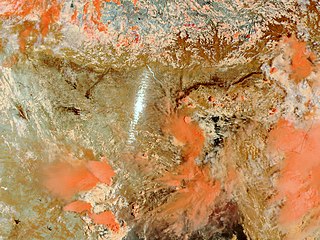
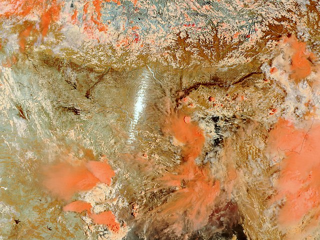
| Description | For the first two weeks of July 2002, floods had ravaged eastern India and northern Bangladesh, killing over 50 people and displacing hundreds of thousands from their homes. This false-color image acquired on July 16, 2002, by the Moderate Resolution Imaging Spectroradiometer (MODIS) aboard NASA's Terra spacecraft shows some of the worst flooding. The dark brown swollen river at the top of the image is the Brahmaputra River, which flows through the middle of the Indian state of Assam. Normally, the river and its tributaries would resemble a tangle of thin lines. Cloud cover obstructs additonal flooding in northern Bangladesh. In this false-color image, land is tan, and clouds are pink and white. Water comes across as black or dark brown. |
| Date | |
| Source | Earth Observatory, NASA |
| Author | Jacques Descloitres, MODIS Land Rapid Response Team at NASA GSFC. |
| Other versions | Detail crop here. |
Licensing
[edit]
| This file is in the public domain in the United States because it was solely created by NASA. NASA copyright policy states that "NASA material is not protected by copyright unless noted". (See Template:PD-USGov, NASA copyright policy page or JPL Image Use Policy.) | ||
 |
Warnings:
|
File history
Click on a date/time to view the file as it appeared at that time.
| Date/Time | Thumbnail | Dimensions | User | Comment | |
|---|---|---|---|---|---|
| current | 01:35, 22 July 2007 | | 4,800 × 3,600 (3.55 MB) | Armanaziz (talk | contribs) | For the first two weeks of July 2002, floods had ravaged eastern India and northern Bangladesh, killing over 50 people and displacing hundreds of thousands from their homes. This false-color image acquired on July 16, 2002, by the Moderate Resolution Imag |
You cannot overwrite this file.
File usage on Commons
There are no pages that use this file.