File:B&A Map.JPG
Jump to navigation
Jump to search
No higher resolution available.
B&A_Map.JPG (244 × 512 pixels, file size: 44 KB, MIME type: image/jpeg)
Captions
Captions
Add a one-line explanation of what this file represents
Summary
[edit]
| Description |
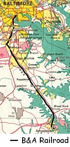
English: Map of the Baltimore and Annapolis Railroad |
| Date | |
| Source | 1970 National Atlas Map |
| Author | Modifications made by Volcycle at English Wikipedia |
Licensing
[edit]
This map was obtained from an edition of the National Atlas of the United States. Like almost all works of the U.S. federal government, works from the National Atlas are in the public domain in the United States.
Online access: NationalAtlas.gov | 1970 print edition: Library of Congress, Perry-Castañeda Library
|
Original upload log
[edit]
The original description page was here. All following user names refer to en.wikipedia.
- 2006-11-20 02:56 Volcycle 244×512× (45139 bytes) Modified picture from U.S.National Atlas 1970 found at http://www.lib.utexas.edu/maps/world_cities/washington_baltimore.jpg
File history
Click on a date/time to view the file as it appeared at that time.
| Date/Time | Thumbnail | Dimensions | User | Comment | |
|---|---|---|---|---|---|
| current | 04:56, 18 February 2011 | | 244 × 512 (44 KB) | File Upload Bot (Magnus Manske) (talk | contribs) | {{BotMoveToCommons|en.wikipedia|year={{subst:CURRENTYEAR}}|month={{subst:CURRENTMONTHNAME}}|day={{subst:CURRENTDAY}}}} {{Information |Description={{en|Modified picture from U.S.National Atlas 1970 found at http://www.lib.utexas.edu/maps/world_cities/wash |
You cannot overwrite this file.
File usage on Commons
The following page uses this file:
File usage on other wikis
The following other wikis use this file:
- Usage on en.wikipedia.org
- Usage on www.wikidata.org