File:Aztec Empire 1519 map-fr.svg
Jump to navigation
Jump to search

Size of this PNG preview of this SVG file: 778 × 599 pixels. Other resolutions: 312 × 240 pixels | 623 × 480 pixels | 997 × 768 pixels | 1,280 × 986 pixels | 2,560 × 1,972 pixels | 1,898 × 1,462 pixels.
Original file (SVG file, nominally 1,898 × 1,462 pixels, file size: 303 KB)
Captions
Captions
Add a one-line explanation of what this file represents
Summary
[edit]| Description |
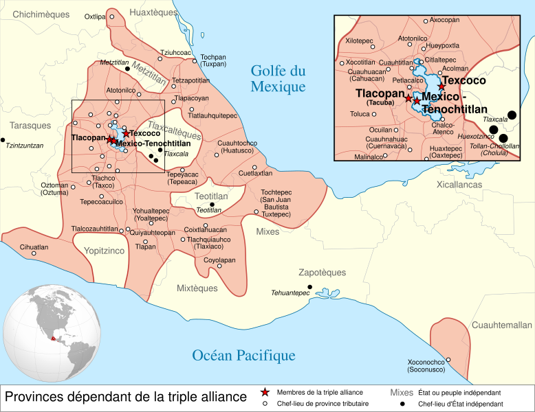
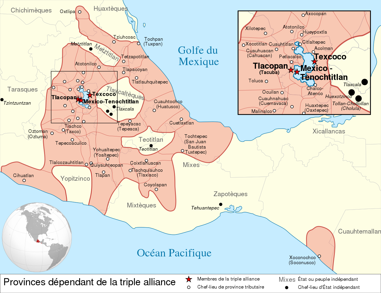
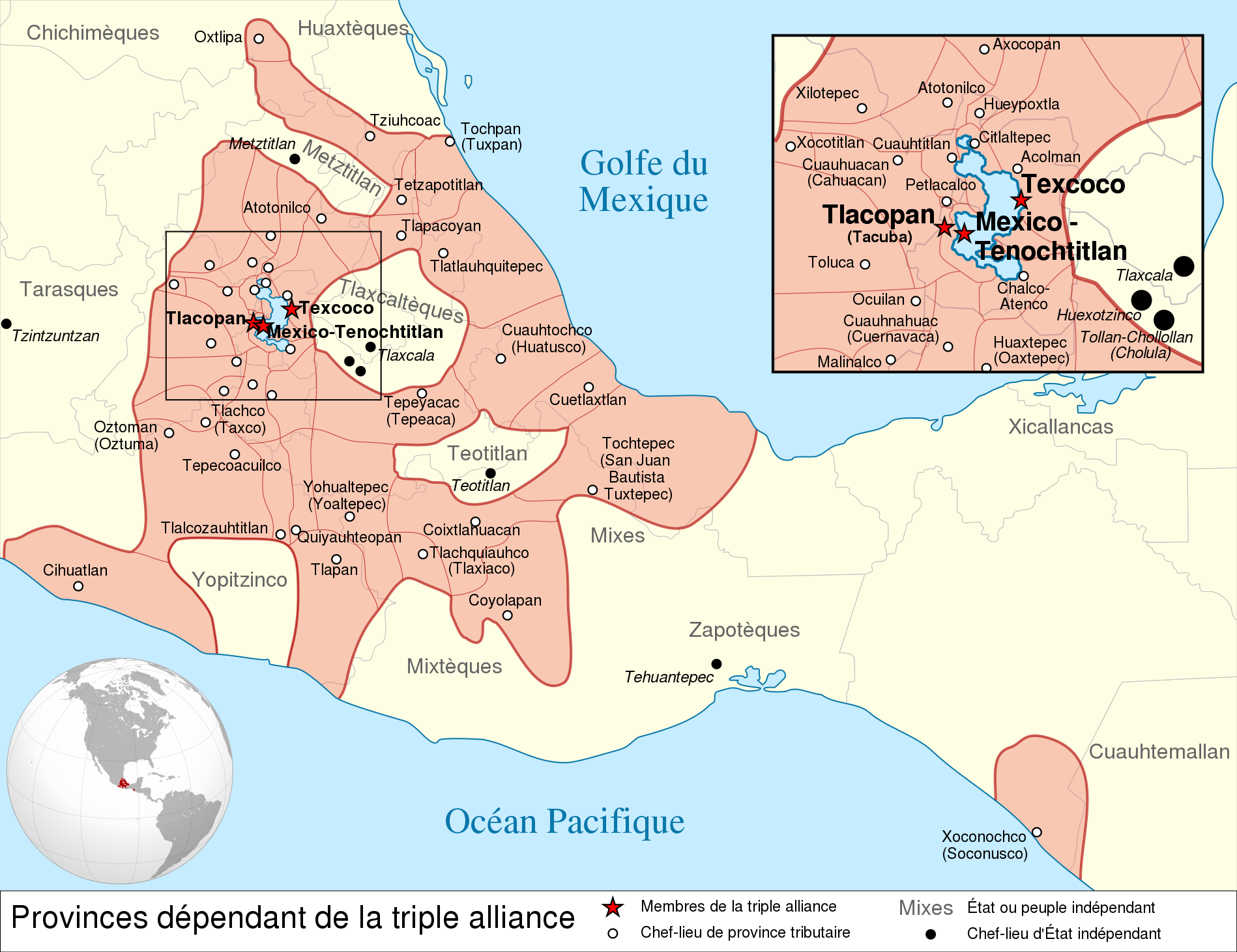
Español: Provincias tributarias de la Triple Alianza encabezada por Tenochtitlan antes de la llegada de los españoles en 1519.
English: Map of the Aztec Empire lead by Tenochtitlan circa 1519, before the arrival of the Spanish.
Français : Étendue de l'empire Aztèque soumis à la Triple Alliance, dirigée par Tenochtitlan, à l'arrivée des Espagnols en 1519. |
| Date | (UTC) |
| Source |
|
| Author | |
| Other versions |
[] Detailed maps[edit]
Simple maps[edit]
|


.svg)
.svg)
.svg)
| Camera location | | View this and other nearby images on: OpenStreetMap |
|---|

|
This SVG file contains embedded text that can be translated into your language, using any capable SVG editor, text editor or the SVG Translate tool. For more information see: About translating SVG files. |
This W3C-unspecified vector image was created with Inkscape .
Licensing
[edit]
This file is licensed under the Creative Commons Attribution-Share Alike 3.0 Unported license.
- You are free:
- to share – to copy, distribute and transmit the work
- to remix – to adapt the work
- Under the following conditions:
- attribution – You must give appropriate credit, provide a link to the license, and indicate if changes were made. You may do so in any reasonable manner, but not in any way that suggests the licensor endorses you or your use.
- share alike – If you remix, transform, or build upon the material, you must distribute your contributions under the same or compatible license as the original.
Original upload log
[edit]
This image is a derivative work of the following images:
- File:Provincias_tributarias_de_la_Triple_Alianza_(s._XVI).svg licensed with Cc-by-sa-3.0-migrated, FAL, GFDL
- 2008-12-13T03:29:16Z Yavidaxiu 949x731 (878329 Bytes) {{Information |Description={{es|1=Provincias tributarias de la Triple Alianza encabezada por Tenochtitlan antes de la llegada de los españoles. Fuente: ''Atlas del México prehispánico'', edición especial de ''Arqueología
- File:Aztec_Empire_(orthographic_projection).svg licensed with Cc-by-sa-3.0, GFDL
- 2010-02-11T12:23:41Z Sémhur 550x550 (104628 Bytes) Update with data from a sourced map.
- 2010-01-10T20:34:52Z Keepscases 550x550 (284361 Bytes) {{Information |Description={{en|1=Aztec Empire (orthographic projection)}} |Source={{own}} |Author=[[User:Keepscases|Keepscases]] |Date= |Permission= |other_versions= }} [[Category:SVG - Orthographic projections]]
Uploaded with derivativeFX
File history
Click on a date/time to view the file as it appeared at that time.
| Date/Time | Thumbnail | Dimensions | User | Comment | |
|---|---|---|---|---|---|
| current | 15:01, 23 March 2010 | | 1,898 × 1,462 (303 KB) | El Comandante (talk | contribs) | État tarasque->Tarasques + Royaumes mixtèques->Mixtèques + Correction du positionnement de 2 textes |
| 17:58, 7 March 2010 |  | 1,898 × 1,462 (303 KB) | El Comandante (talk | contribs) | More readable fonts | |
| 18:06, 25 February 2010 |  | 1,898 × 1,462 (306 KB) | Sémhur (talk | contribs) | Font : Nimbus Sans L | |
| 17:29, 24 February 2010 |  | 949 × 731 (305 KB) | Sémhur (talk | contribs) | 2 - Encart de la région centrale | |
| 12:55, 11 February 2010 |  | 949 × 731 (262 KB) | Sémhur (talk | contribs) | == {{int:filedesc}} == {{Information |Description={{es|1=Provincias tributarias de la Triple Alianza encabezada por Tenochtitlan antes de la llegada de los españoles en 1519.}} {{en|1=Map of the [[:en:Aztec Empire[Aztec Empire]] lead by Tenochtitlan circ |
You cannot overwrite this file.
File usage on Commons
The following 12 pages use this file:
- File:Az Azték Birodalom 1519-ben.png
- File:Aztec Empire 1519 map-fr.svg
- File:Aztec Empire 1519 map-hu.svg
- File:Aztec Empire 1519 map-pt.svg
- File:Aztec Empire 1519 map-zh-cn.svg
- File:Aztec Empire c 1519.png
- File:Aztec empire 1519-el.svg
- File:Aztec empire 1519-fr.svg
- File:Aztec empire 1519-mk.svg
- File:Aztec empire 1519-nl.svg
- File:Aztecempirelocation.png
- Template:Other versions/Map Aztec Empire 1519
File usage on other wikis
The following other wikis use this file:
- Usage on af.wikipedia.org
- Usage on ar.wikipedia.org
- Usage on azb.wikipedia.org
- Usage on br.wikipedia.org
- Usage on el.wikipedia.org
- Usage on en.wikipedia.org
- Aztecs
- List of conflicts in North America
- Aztec Empire
- Wikipedia:WikiProject Aztec/Backup 2006-07-17
- Tlaxcala (Nahua state)
- Aztec architecture
- User:Maunus/sandbox
- Template:Aztec
- List of conflicts in Mexico
- User:Bobo.03/sandbox
- Xihuitl Temoc
- User:SomeGuyWhoRandomlyEdits/List of conflicts in Mexico
- Talk:Aztec Empire/Archive 1
- List of conflicts in the Americas
- Usage on en.wikibooks.org
- Usage on fi.wikipedia.org
- Usage on fr.wikipedia.org
- Usage on hy.wikipedia.org
- Usage on id.wikipedia.org
- Usage on id.wikibooks.org
- Usage on it.wikipedia.org
View more global usage of this file.