File:Ayyubid Dynasty ar.png
Jump to navigation
Jump to search

Size of this preview: 800 × 487 pixels. Other resolutions: 320 × 195 pixels | 640 × 389 pixels | 1,024 × 623 pixels | 1,280 × 779 pixels | 2,012 × 1,224 pixels.
Original file (2,012 × 1,224 pixels, file size: 346 KB, MIME type: image/png)
Captions
Captions
Add a one-line explanation of what this file represents
| Description |
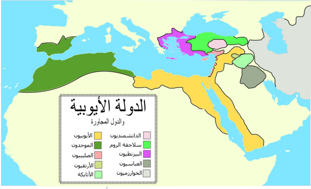
العربية: خريطة الدولة الأيوبيّة والدول المجاورة خلال القرن الثاني عشر. |
| Date | (UTC) |
| Source | |
| Author |
|
| This is a retouched picture, which means that it has been digitally altered from its original version. Modifications: translated to arabic. The original can be viewed here: Ayyubid Dynasty.svg:
|
I, the copyright holder of this work, hereby publish it under the following licenses:
This file is licensed under the Creative Commons Attribution-Share Alike 3.0 Unported license.
- You are free:
- to share – to copy, distribute and transmit the work
- to remix – to adapt the work
- Under the following conditions:
- attribution – You must give appropriate credit, provide a link to the license, and indicate if changes were made. You may do so in any reasonable manner, but not in any way that suggests the licensor endorses you or your use.
- share alike – If you remix, transform, or build upon the material, you must distribute your contributions under the same or compatible license as the original.

|
Permission is granted to copy, distribute and/or modify this document under the terms of the GNU Free Documentation License, Version 1.2 or any later version published by the Free Software Foundation; with no Invariant Sections, no Front-Cover Texts, and no Back-Cover Texts. A copy of the license is included in the section entitled GNU Free Documentation License. |
You may select the license of your choice.
Original upload log
[edit]
This image is a derivative work of the following images:
- File:Ayyubid_Dynasty.svg licensed with Cc-by-sa-3.0, GFDL
- 2009-07-14T22:38:09Z Fjmustak 2007x1204 (226731 Bytes) Used Arial font for the legend.
- 2009-05-22T06:45:40Z Fjmustak 2007x1204 (220195 Bytes) Removed black box
- 2009-05-22T06:34:40Z Fjmustak 2007x1204 (219289 Bytes) Removed distinction between Fatimid held areas and rest of Ayyubid Dynasty, added Almohads, legend + minor changes.
- 2009-05-14T06:02:28Z Fjmustak 2007x1204 (206788 Bytes) Fixed size
- 2009-05-14T05:53:47Z Fjmustak 940x477 (206778 Bytes) {{Information |Description={{en|1=Map of the Ayyubid empire and the surrounding empires in the 12th century. Yellow area is the area under Fatimid rule until 1171, and the "peach" colored areas are the regions conquered by S
Uploaded with derivativeFX
File history
Click on a date/time to view the file as it appeared at that time.
| Date/Time | Thumbnail | Dimensions | User | Comment | |
|---|---|---|---|---|---|
| current | 21:56, 5 July 2012 | | 2,012 × 1,224 (346 KB) | باسم (talk | contribs) | Bigger and clearer Font is used. colored boxed are moved to the right, direction of Arabic writing. |
| 18:37, 24 March 2011 |  | 625 × 378 (96 KB) | باسم (talk | contribs) | {{Information |Description={{ar|1=خريطة الدولة الأيوبيّة والدول المجاورة خلال القرن الثاني عشر.}} |Source=*File:Ayyubid_Dynasty.svg |Date=2011-03-24 18:36 (UTC) |Author=*[[:File:Ayyubid_Dynasty.svg |
You cannot overwrite this file.
File usage on Commons
There are no pages that use this file.
File usage on other wikis
The following other wikis use this file:
- Usage on ar.wikipedia.org
- Usage on ckb.wikipedia.org