File:Aveiro lagoon in Portugal.jpg

Original file (3,995 × 2,540 pixels, file size: 4.49 MB, MIME type: image/jpeg)
Captions
Captions
Summary
[edit]
| Description |
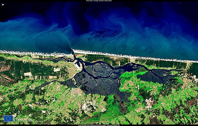
English: The Aveiro lagoon (Ria de Aveiro) in Portugal is a coastal wetland that comprises beaches, dunes, mudflats, salt marshes, seagrasses and small water channels. Due to its rich biodiversity and role in hosting numerous invaluable habitats, the impressive natural capital of the Aveiro lagoon has had it classified as a Natura 2000 site, with a designation as a Special Protection Zone and a Site of Community Importance under the EU Birds and Habitats Directives. The Aveiro lagoon is also part of the European Fisheries Areas Network (FARNET) and it maintains sustainable development practices for fisheries and coastal areas through the activities of the Aveiro Fisheries Local Action Group — a partnership between fisheries actors and other private and public stakeholders. This image was acquired by one of the Copernicus Sentinel-2 satellites on 15 March 2021. Data provided by the Copernicus satellites and services allow for the extraction of fundamental information on the state of implementation of European policies, including those that concern the operation and development of fisheries and agricultural areas, as well as the protection of crucial biodiversity sites. |
| Date | Taken on 15 March 2021 |
| Source | Aveiro lagoon in Portugal |
| Author | European Union , Copernicus Sentinel-2 imagery |
Licensing
[edit]

|
This image contains data from a satellite in the Copernicus Programme, such as Sentinel-1, Sentinel-2 or Sentinel-3. Attribution is required when using this image.
Attribution: Contains modified Copernicus Sentinel data 2021
The use of Copernicus Sentinel Data is regulated under EU law (Commission Delegated Regulation (EU) No 1159/2013 and Regulation (EU) No 377/2014). Relevant excerpts:
Free access shall be given to GMES dedicated data [...] made available through GMES dissemination platforms [...].
Access to GMES dedicated data [...] shall be given for the purpose of the following use in so far as it is lawful:
GMES dedicated data [...] may be used worldwide without limitations in time.
GMES dedicated data and GMES service information are provided to users without any express or implied warranty, including as regards quality and suitability for any purpose. |
File history
Click on a date/time to view the file as it appeared at that time.
| Date/Time | Thumbnail | Dimensions | User | Comment | |
|---|---|---|---|---|---|
| current | 08:32, 27 August 2023 | | 3,995 × 2,540 (4.49 MB) | OptimusPrimeBot (talk | contribs) | #Spacemedia - Upload of https://www.copernicus.eu/system/files/2021-03/image_day/RiaDeAveiro.jpg via Commons:Spacemedia |
You cannot overwrite this file.
File usage on Commons
There are no pages that use this file.