File:Autódromo Oscar Alfredo Gálvez - zoomed out.png
Jump to navigation
Jump to search

Size of this preview: 800 × 297 pixels. Other resolutions: 320 × 119 pixels | 640 × 238 pixels | 1,024 × 380 pixels | 1,280 × 475 pixels | 4,441 × 1,649 pixels.
Original file (4,441 × 1,649 pixels, file size: 688 KB, MIME type: image/png)
Captions
Captions
Add a one-line explanation of what this file represents
Summary
[edit]| Description |
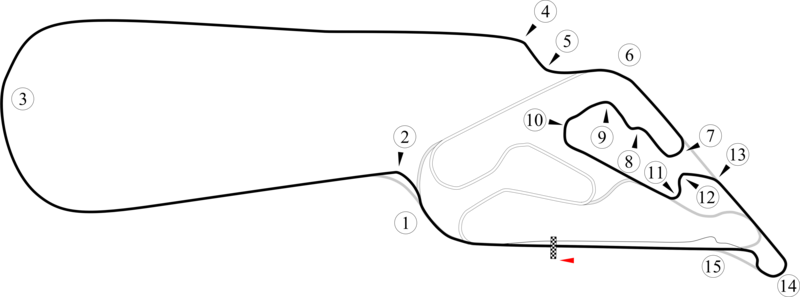
English: Track map for Autódromo Oscar Alfredo Gálvez that shows the route around the lake. This PNG version is intended for those with browsers like IE7 that don't support SVG. The track sections that can't be used with the lake extension are shown semi-transparent. |
|||
| Date | 7-6-2008 | |||
| Source | Own work | |||
| Author | Will Pittenger | |||
| Other versions |
|


| Camera location | | View this and other nearby images on: OpenStreetMap |
|---|
Licensing
[edit]
| I, the copyright holder of this work, release this work into the public domain. This applies worldwide. In some countries this may not be legally possible; if so: I grant anyone the right to use this work for any purpose, without any conditions, unless such conditions are required by law. |
File history
Click on a date/time to view the file as it appeared at that time.
| Date/Time | Thumbnail | Dimensions | User | Comment | |
|---|---|---|---|---|---|
| current | 07:15, 6 July 2008 | 4,441 × 1,649 (688 KB) | Will Pittenger (talk | contribs) | New version that is smaller (less than 12.5 million pixels) to allow server to generate thumbs. | |
| 07:09, 6 July 2008 | 6,344 × 2,356 (763 KB) | Will Pittenger (talk | contribs) | {{Information |Description={{en|1=Track map for w:Autódromo Oscar Alfredo Gálvez that shows the route around the lake. This PNG version is intended for those with browsers like IE7 that don't support SVG. The track sections that can't be used wit |
You cannot overwrite this file.
File usage on Commons
The following page uses this file: