File:Australian desert ESA345627.jpg

Original file (1,680 × 1,920 pixels, file size: 4.7 MB, MIME type: image/jpeg)
Captions
Captions
Summary
[edit]| Description |
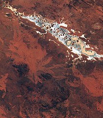
English: This spectacular image captured by Sentinel-2A on 13 July features Lake Amadeus, in Australia’s Northern Territory.
It shows the variety of the sandy, rocky and salty formations within the lake. Around 180 km long and 10 km wide, Amadeus is the largest salt lake in the Northern Territory, just 50 km north of Uluru/ Ayers Rock. Lake Amadeus contains up to 600 million tonnes of salt. However, harvesting is not feasible because of its remote location. Owing to the aridity of the area, the surface of Lake Amadeus is often a dry salt crust. When rainfall is sufficient, it becomes part of an east-flowing drainage system that eventually connects to the Finke River. A UNESCO World Heritage Site and one of Australia’s most recognisable landmarks, Uluru/Ayers Rock is a large sandstone rock formation standing 348 m high, rising 863 m above sea level and with a circumference of 9.4 km. Also clearly visible in the lower-central part of the image are the Petermann Ranges. These mountains run 320 km across the border between Western Australia and the southwest corner of the Northern Territory. Their highest point is 1158 m above sea level. The range was formed about 550 million years ago as compression folded a section of Earth’s crust. Launched in June, Sentinel-2A – the most recent satellite in orbit for Europe’s Copernicus programme – provides detailed information about Earth’s land cover and inland water bodies, helping us to understand Earth’s varied landscape. This image is also featured on the Earth from Space video programme. |
| Date | |
| Source | http://www.esa.int/spaceinimages/Images/2015/09/Australian_desert |
| Author | European Space Agency |
| Permission (Reusing this file) |
Copernicus Sentinel data (2015)/ESA,CC BY-SA 3.0 IGO |
| Title | Australian desert |
| Set | Earth observation image of the week |
| System | Copernicus |
| Mission | Sentinel-2 |
| Location | Australia |
| Activity | Observing the Earth |
| Keywords | Deserts; Lakes; Satellite image |
| Object location | | View this and other nearby images on: OpenStreetMap |
|---|

Licensing
[edit]
- You are free:
- to share – to copy, distribute and transmit the work
- to remix – to adapt the work
- Under the following conditions:
- attribution – You must give appropriate credit, provide a link to the license, and indicate if changes were made. You may do so in any reasonable manner, but not in any way that suggests the licensor endorses you or your use.
- share alike – If you remix, transform, or build upon the material, you must distribute your contributions under the same or compatible license as the original.
| Annotations | This image is annotated: View the annotations at Commons |
File history
Click on a date/time to view the file as it appeared at that time.
| Date/Time | Thumbnail | Dimensions | User | Comment | |
|---|---|---|---|---|---|
| current | 16:16, 6 May 2017 | | 1,680 × 1,920 (4.7 MB) | Fæ (talk | contribs) | == {{int:filedesc}} == {{information | description = {{en|1=This spectacular image captured by Sentinel-2A on 13 July features Lake Amadeus, in Australia’s Northern Territory. It shows the variety of the sandy, rocky and salty formations within the l... |
You cannot overwrite this file.
File usage on Commons
The following page uses this file:
File usage on other wikis
The following other wikis use this file:
- Usage on ru.wikipedia.org