File:Australia's Channel Country (MODIS 2024-04-12).jpg

Original file (3,014 × 2,244 pixels, file size: 3.36 MB, MIME type: image/jpeg)
Captions
Captions
Summary
[edit].jpg&action=edit§ion=1)
| Description |
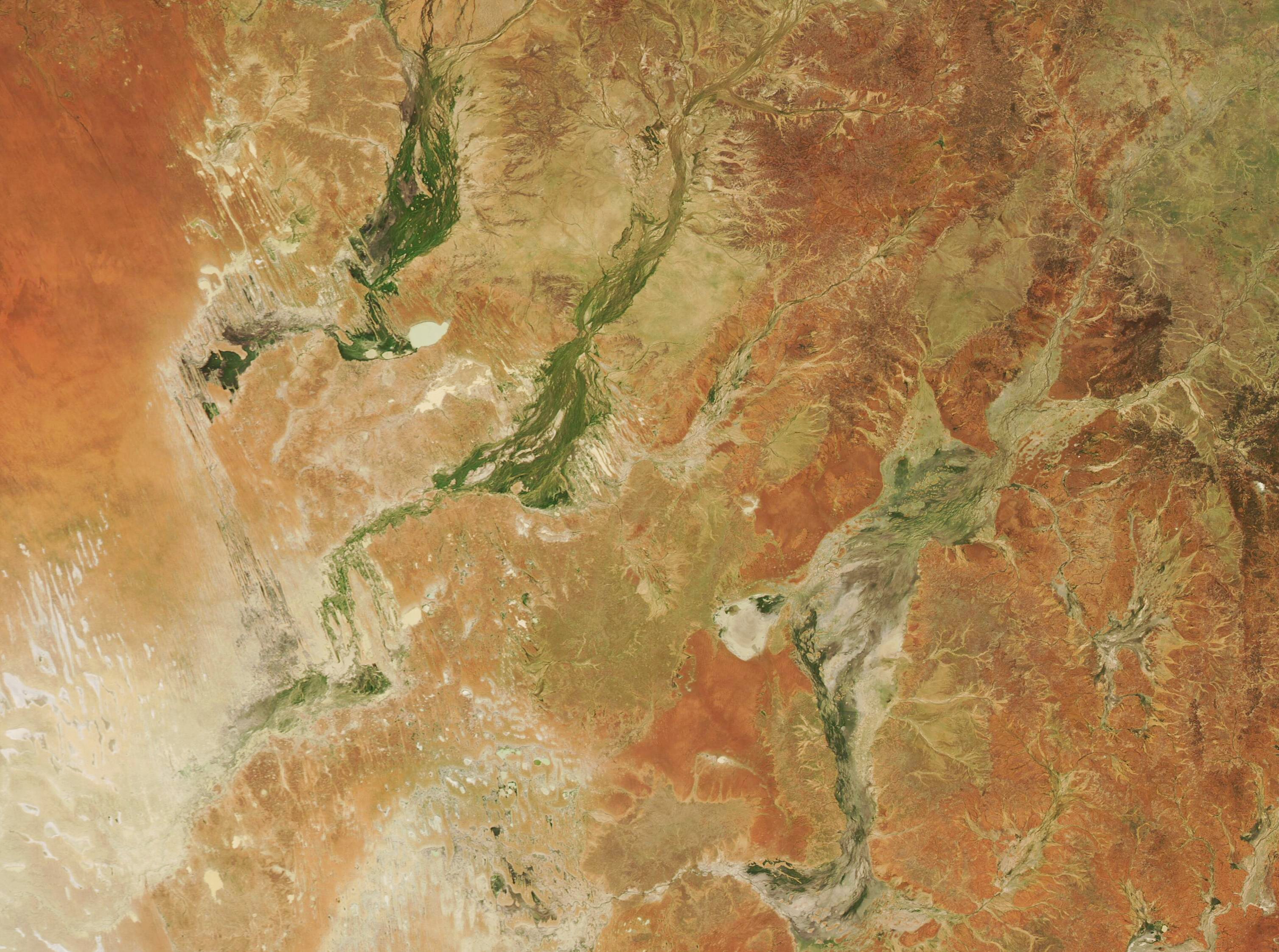
English: In Queensland, fierce storms in January brought stunning greening to Australia’s Channel Country in April.
In late January and early February 2024, Queensland received a major drenching from Tropical Cyclone Kirrily. According to the Queensland Government website, a meter of rain (3.3 feet) fell in the northern part of the state near landfall on January 25. Then, between January 29-30, more than 300 mm (11 inches) fell in southeast Queensland. Additional soaking occurred from the storm’s remnants and from moisture-laden low pressure systems in the region through late February. Since mid-February, stormwater has been moving slowly southward through Australia’s Channel Country, covering about 8-10 kilometers (5-6.2 miles) per day, according to the Australia Bureau of Meteorology (BoM), ultimately heading to South Australia’s Lake Eyre. The Channel Country bioregion is made up of a vast area of arid and semi-arid land across parts of Queensland, South Australia, Northern Territory, and New South Wales, with about seventy percent found in southwestern Queensland. Most of the crisscrossing channels are ephemeral, filling with water only in heavy flood conditions. On April 10, 2024, the Moderate Resolution Imaging Spectroradiometer (MODIS) acquired a true-color image of greening along the Georgina, Diamantina, and Coopers Creek Rivers in the Queensland portion of Australia’s Channel Country. Floodwaters reached these rivers by March 19, according to the BoM, and continued to creep southward. By April 9, water had reached the northern tip of Kati Thanda-Lake Eyre (located south of this image). Meanwhile, the arid lands surrounding the Channel Country rivers had burst forth in glorious green vegetation. |
||
| Date | Taken on 10 April 2024 | ||
| Source |
Australia's Channel Country (direct link)
|
||
| Author | MODIS Land Rapid Response Team, NASA GSFC |
| This media is a product of the Aqua mission Credit and attribution belongs to the mission team, if not already specified in the "author" row |
Licensing
[edit].jpg&action=edit§ion=2)
| This file is in the public domain in the United States because it was solely created by NASA. NASA copyright policy states that "NASA material is not protected by copyright unless noted". (See Template:PD-USGov, NASA copyright policy page or JPL Image Use Policy.) | ||
 |
Warnings:
|
File history
Click on a date/time to view the file as it appeared at that time.
| Date/Time | Thumbnail | Dimensions | User | Comment | |
|---|---|---|---|---|---|
| current | 21:22, 18 May 2024 | | 3,014 × 2,244 (3.36 MB) | OptimusPrimeBot (talk | contribs) | #Spacemedia - Upload of http://modis.gsfc.nasa.gov/gallery/images/image04122024_250m.jpg via Commons:Spacemedia |
You cannot overwrite this file.
File usage on Commons
There are no pages that use this file.
.jpg&oldid=909380109)