File:Aurora Bridge 01.jpg

Original file (2,592 × 1,944 pixels, file size: 849 KB, MIME type: image/jpeg)
Captions
Captions
|
This is an image of a place or building that is listed on the National Register of Historic Places in the United States of America. Its reference number is 82004230. |
Summary
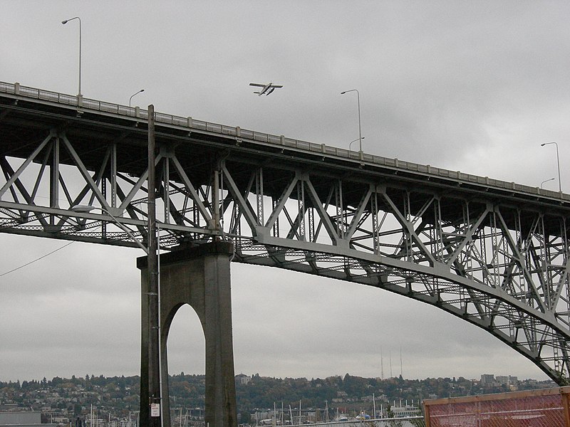
[edit]| DescriptionAurora Bridge 01.jpg | Aurora Bridge (officially George Washington Memorial Bridge, but the name is almost never used), Seattle, Washington. The bridge is part of Washington State Route 99 / Aurora Avenue. Photographed here from the Fremont side; Capitol Hill is in the background. A seaplane can be seen flying over the bridge. |
| Date | |
| Source | Photo by Joe Mabel |
| Author | Joe Mabel |
| Permission (Reusing this file) |
GFDL granted by photographer |
| Object location | 47° 39′ 10″ N, 122° 20′ 46″ W | View this and other nearby images on: OpenStreetMap |
|---|
Licensing
[edit]
|
Permission is granted to copy, distribute and/or modify this document under the terms of the GNU Free Documentation License, Version 1.2 or any later version published by the Free Software Foundation; with no Invariant Sections, no Front-Cover Texts, and no Back-Cover Texts. A copy of the license is included in the section entitled GNU Free Documentation License.http://www.gnu.org/copyleft/fdl.htmlGFDLGNU Free Documentation Licensetruetrue |
| This file is licensed under the Creative Commons Attribution-Share Alike 3.0 Unported license. | ||
| ||
| This licensing tag was added to this file as part of the GFDL licensing update.http://creativecommons.org/licenses/by-sa/3.0/CC BY-SA 3.0Creative Commons Attribution-Share Alike 3.0truetrue |
File history
Click on a date/time to view the file as it appeared at that time.
| Date/Time | Thumbnail | Dimensions | User | Comment | |
|---|---|---|---|---|---|
| current | 08:08, 1 December 2006 |  | 2,592 × 1,944 (849 KB) | Jmabel (talk | contribs) | {{Information |Description=Aurora Bridge (officially George Washington Memorial Bridge, but the name is almost never used), Seattle, Washington. The bridge is part of Washington State Route 99 / Aurora Avenue. Photographed here from the Fremont side; Capi |
You cannot overwrite this file.
File usage on Commons
There are no pages that use this file.
Metadata
This file contains additional information such as Exif metadata which may have been added by the digital camera, scanner, or software program used to create or digitize it. If the file has been modified from its original state, some details such as the timestamp may not fully reflect those of the original file. The timestamp is only as accurate as the clock in the camera, and it may be completely wrong.
| Camera manufacturer | NIKON |
|---|---|
| Camera model | COOLPIX P2 |
| Exposure time | 2/383 sec (0.0052219321148825) |
| F-number | f/5.5 |
| ISO speed rating | 400 |
| Date and time of data generation | 15:16, 19 October 2006 |
| Lens focal length | 13.7 mm |
| Orientation | Normal |
| Horizontal resolution | 300 dpi |
| Vertical resolution | 300 dpi |
| Software used | COOLPIX P2v1.0 |
| File change date and time | 15:16, 19 October 2006 |
| Y and C positioning | Co-sited |
| Exposure Program | Normal program |
| Exif version | 2.2 |
| Date and time of digitizing | 15:16, 19 October 2006 |
| Image compression mode | 2 |
| APEX exposure bias | 0 |
| Maximum land aperture | 2.9 APEX (f/2.73) |
| Metering mode | Center weighted average |
| Light source | Unknown |
| Flash | Flash did not fire, compulsory flash suppression |
| Color space | sRGB |
| Custom image processing | Normal process |
| Exposure mode | Auto exposure |
| White balance | Auto white balance |
| Digital zoom ratio | 0 |
| Focal length in 35 mm film | 66 mm |
| Scene capture type | Standard |
| Contrast | Normal |
| Saturation | Normal |
| Sharpness | Normal |
| Subject distance range | Unknown |