File:Augsburg Karte vom Brunnenbach.jpg
Jump to navigation
Jump to search
Size of this preview: 154 × 596 pixels. Other resolutions: 62 × 240 pixels | 124 × 480 pixels | 944 × 3,656 pixels.
Original file (944 × 3,656 pixels, file size: 1.26 MB, MIME type: image/jpeg)
Captions
Captions
Add a one-line explanation of what this file represents
Summary
[edit]
| Description |
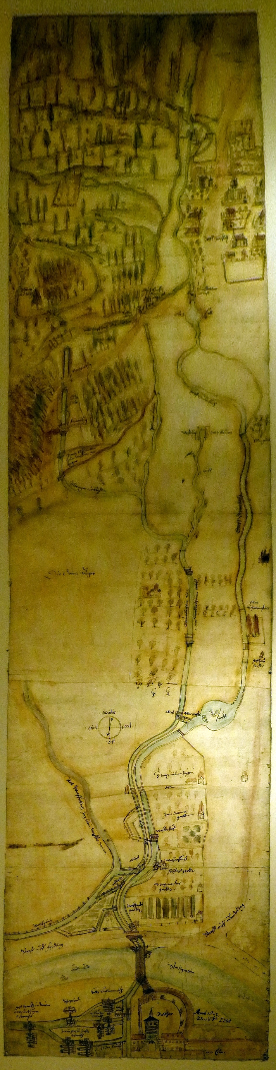
Deutsch: Historische Karte von Elias Holl mit dem Verlauf des Brunnenbachs und anderer Bäche, Straßen und sonstigen Features. Die Karte ist gesüdet. Unten in der Karte befindet sich das Rote Tor, oben ist die Richtung Haunstetten, flussaufwärts. |
| Date | |
| Source | Karten-Repro im Wasserwerk am Roten Tor, Augsburg. |
| Author | Elias Holl |
Licensing
[edit]
|
This work is in the public domain in its country of origin and other countries and areas where the copyright term is the author's life plus 100 years or fewer. | |
| This file has been identified as being free of known restrictions under copyright law, including all related and neighboring rights. | |
File history
Click on a date/time to view the file as it appeared at that time.
| Date/Time | Thumbnail | Dimensions | User | Comment | |
|---|---|---|---|---|---|
| current | 22:36, 7 September 2014 | 944 × 3,656 (1.26 MB) | Neitram (talk | contribs) | {{Information |Description= {{de|1=Historische Karte mit dem Verlauf des Brunnenbachs und anderer Bäche, Straßen und sonstigen Features. Die Karte ist gesüdet. Unten in der Karte befindet sich das Rote Tor, oben ist die Richtung Haunstetten, flussau... |
You cannot overwrite this file.
File usage on Commons
There are no pages that use this file.
File usage on other wikis
The following other wikis use this file:
- Usage on de.wikipedia.org