File:Atlas of the Mexican conflict - containing detailed maps showing the territory involved, pertinent statistics of Mexico and the United States, summary of recent events in Mexico. LOC 2012589700-10.jpg
Jump to navigation
Jump to search

Size of this preview: 732 × 599 pixels. Other resolutions: 293 × 240 pixels | 586 × 480 pixels | 938 × 768 pixels | 1,251 × 1,024 pixels | 2,502 × 2,048 pixels | 4,341 × 3,554 pixels.
Original file (4,341 × 3,554 pixels, file size: 2.79 MB, MIME type: image/jpeg)
Captions
Captions
Add a one-line explanation of what this file represents
Summary
[edit]| Description |
English: Phillips, 5119 Available also through the Library of Congress Web site as a raster image. |
||
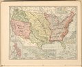
| Title | Atlas of the Mexican conflict : containing detailed maps showing the territory involved, pertinent statistics of Mexico and the United States, summary of recent events in Mexico. | ||
| Shelf ID | G1546.S6 R3 1913 | ||
| Parent | https://www.loc.gov/resource/g4411sm.gct00282/ | ||
| Sheet title | United States and possessions | ||
| Date | |||
| Source | https://www.loc.gov/item/2012589700/ | ||
| Author | Rand Mcnally And Company | ||
| Permission (Reusing this file) |
|
||
| Other versions |
|
||
| Location | Mexico | ||
| Part of | Military Battles And Campaigns · American Memory · Catalog · Geography And Map Division | ||
| Subject | Atlases · Revolution · Historical Geography · Mexico · 20Th Century · Military Maps · Maps · History, Military · History |

Licensing
[edit]
|
This is a faithful photographic reproduction of a two-dimensional, public domain work of art. The work of art itself is in the public domain for the following reason:
The official position taken by the Wikimedia Foundation is that "faithful reproductions of two-dimensional public domain works of art are public domain".
This photographic reproduction is therefore also considered to be in the public domain in the United States. In other jurisdictions, re-use of this content may be restricted; see Reuse of PD-Art photographs for details. | ||||
File history
Click on a date/time to view the file as it appeared at that time.
| Date/Time | Thumbnail | Dimensions | User | Comment | |
|---|---|---|---|---|---|
| current | 05:47, 16 July 2018 | | 4,341 × 3,554 (2.79 MB) | Fæ (talk | contribs) | LOC Maps multisheet https://www.loc.gov/item/2012589700/ sheet 10 of 11 #13281 |
You cannot overwrite this file.
File usage on Commons
The following page uses this file: