File:Atlas of Ida County, Iowa - containing maps of villages, cities and townships of the county, maps of state, United States and world, farmers directory, business directory, general information. LOC 2010587337-24.jpg
Jump to navigation
Jump to search

Size of this preview: 800 × 490 pixels. Other resolutions: 320 × 196 pixels | 640 × 392 pixels | 1,024 × 627 pixels | 1,280 × 784 pixels | 2,560 × 1,568 pixels | 8,766 × 5,370 pixels.
Original file (8,766 × 5,370 pixels, file size: 12.27 MB, MIME type: image/jpeg)
Captions
Captions
Add a one-line explanation of what this file represents
Summary
[edit]| Description |
English: Includes index, advertisements, and portraits of early Ida County residents. Available also through the Library of Congress Web site as a raster image. LC copy imperfect: Losses to portrait pages. Losses to p. 37-8. Minor foxing throughout. Vendor: John Carbonell Acquisitions control no. 2009-086 |
||
| Title | Atlas of Ida County, Iowa : containing maps of villages, cities and townships of the county, maps of state, United States and world, farmers directory, business directory, general information. | ||
| Shelf ID | G1433.I2 I6 1906 | ||
| Parent | https://www.loc.gov/resource/g4153im.gla00120/ | ||
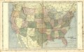
| Sheet title | Map of United States | ||
| Date | |||
| Source | https://www.loc.gov/item/2010587337/ | ||
| Author | Iowa Publishing Co. | ||
| Permission (Reusing this file) |
|
||
| Other versions |
|
||
| Location | Ida County · United States · Iowa | ||
| Part of | American Memory · Catalog · County Landownership Maps · Geography And Map Division · Cultural Landscapes | ||
| Subject | United States · Iowa · Portraits · Directories · Ida County (Iowa) · Ida County · Maps · Real Property · Landowners · Biography |

Licensing
[edit]
|
This is a faithful photographic reproduction of a two-dimensional, public domain work of art. The work of art itself is in the public domain for the following reason:
The official position taken by the Wikimedia Foundation is that "faithful reproductions of two-dimensional public domain works of art are public domain".
This photographic reproduction is therefore also considered to be in the public domain in the United States. In other jurisdictions, re-use of this content may be restricted; see Reuse of PD-Art photographs for details. | ||||
File history
Click on a date/time to view the file as it appeared at that time.
| Date/Time | Thumbnail | Dimensions | User | Comment | |
|---|---|---|---|---|---|
| current | 05:04, 20 May 2018 | | 8,766 × 5,370 (12.27 MB) | Fæ (talk | contribs) | LOC Maps https://www.loc.gov/item/2010587337/ sheet 24 of 59 #281 |
You cannot overwrite this file.
File usage on Commons
The following 2 pages use this file: