File:Atlas of Allamakee County, Iowa - containing maps of townships of the county, maps of state, United States and world, farmers directory, analysis of the system of U.S. land surveys. LOC 2007626986-32.jpg
Jump to navigation
Jump to search
Size of this preview: 717 × 600 pixels. Other resolutions: 287 × 240 pixels | 574 × 480 pixels | 918 × 768 pixels | 1,225 × 1,024 pixels | 2,449 × 2,048 pixels | 2,754 × 2,303 pixels.
Original file (2,754 × 2,303 pixels, file size: 1.35 MB, MIME type: image/jpeg)
Captions
Captions
Add a one-line explanation of what this file represents
Summary
[edit]| Description |
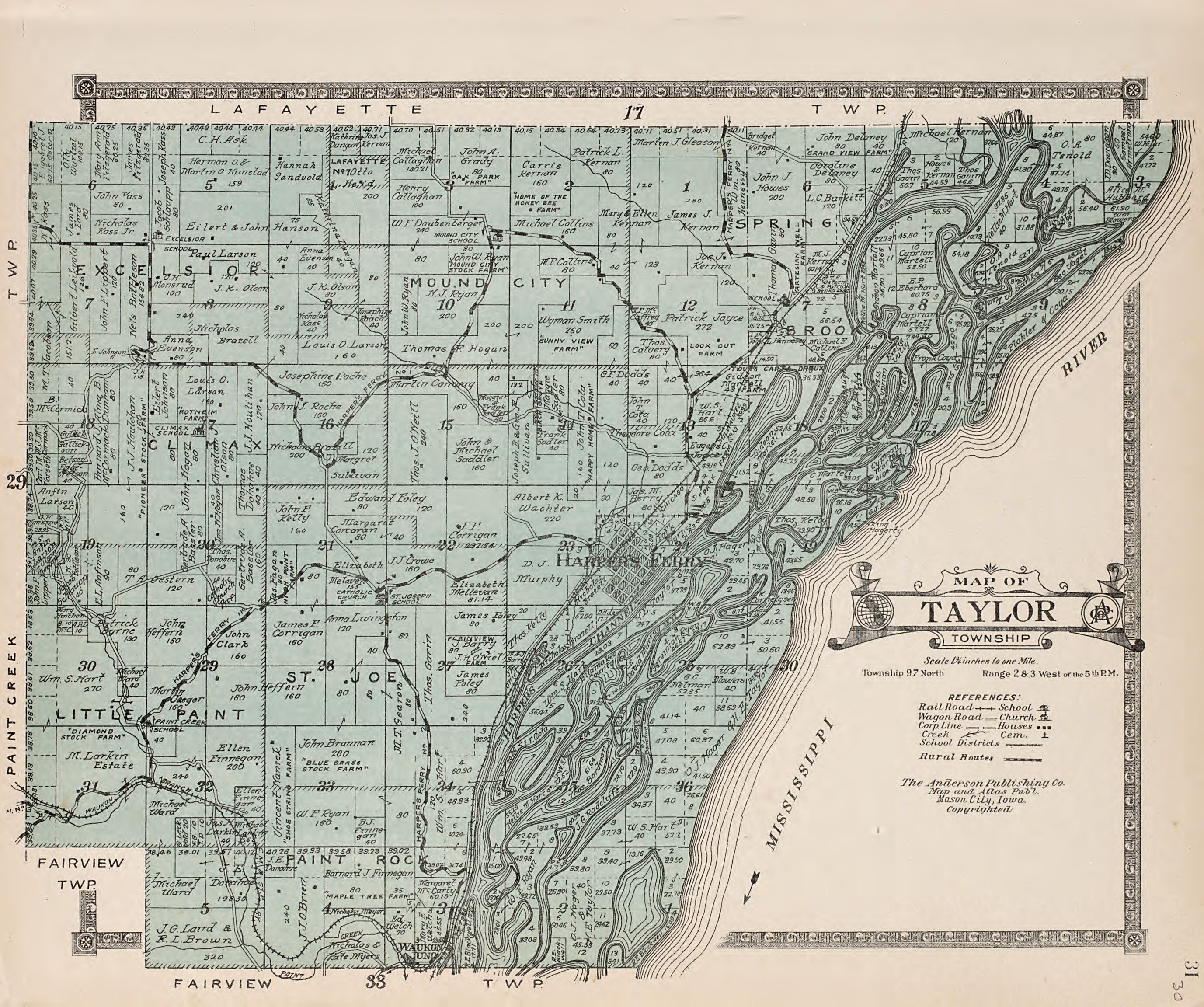
English: Copyright: G.W. Anderson. Differs from other 1917 ed. in disclusion of maps of cities and villages. Available also through the Library of Congress Web site as a raster image. Includes indexes and gazetteer with population of towns. Vendor: Waverly Auctions Acquisitions control no. 2007-074 |
||
| Title | Atlas of Allamakee County, Iowa : containing maps of townships of the county, maps of state, United States and world, farmers directory, analysis of the system of U.S. land surveys. | ||
| Shelf ID | G1433.A5 A52 1917 | ||
| Parent | https://www.loc.gov/resource/g4153am.gla00021/ | ||
| Sheet title | Taylor Township | ||
| Date | |||
| Source | https://www.loc.gov/item/2007626986/ | ||
| Author | Anderson Publishing Company | ||
| Permission (Reusing this file) |
|
||
| Other versions |
|
||
| Location | United States · Allamakee County · Iowa | ||
| Part of | American Memory · Catalog · County Landownership Maps · Geography And Map Division · Cultural Landscapes | ||
| Subject | Iowa · Maps · Directories · United States · Allamakee County · Allamakee County (Iowa) · Real Property · Landowners · Gazetteers |


Licensing
[edit]
|
This is a faithful photographic reproduction of a two-dimensional, public domain work of art. The work of art itself is in the public domain for the following reason:
The official position taken by the Wikimedia Foundation is that "faithful reproductions of two-dimensional public domain works of art are public domain".
This photographic reproduction is therefore also considered to be in the public domain in the United States. In other jurisdictions, re-use of this content may be restricted; see Reuse of PD-Art photographs for details. | ||||
File history
Click on a date/time to view the file as it appeared at that time.
| Date/Time | Thumbnail | Dimensions | User | Comment | |
|---|---|---|---|---|---|
| current | 18:10, 20 May 2018 | | 2,754 × 2,303 (1.35 MB) | Fæ (talk | contribs) | LOC Maps multisheet https://www.loc.gov/item/2007626986/ sheet 32 of 52 #70 |
You cannot overwrite this file.
File usage on Commons
The following 2 pages use this file: