File:Atlas Van der Hagen-KW1049B12 053-PEDEMONTIVM Et reliquae Ditionesssss Italiae REGIAE CELSITVDINI SABAVDICAE Subditae Cum Regionibus adjacentibus.jpeg
Jump to navigation
Jump to search
Size of this preview: 702 × 600 pixels. Other resolutions: 281 × 240 pixels | 562 × 480 pixels | 899 × 768 pixels | 1,199 × 1,024 pixels | 2,398 × 2,048 pixels | 5,500 × 4,697 pixels.
Original file (5,500 × 4,697 pixels, file size: 4.22 MB, MIME type: image/jpeg)
Captions
Captions
Add a one-line explanation of what this file represents
Summary
[edit]| Dirk Jansz van Santen: Atlas van Dirk van der Hagen (volledig, collectie KB)
|
||||||||||||||||||||||||||||||||||||||||||||
|---|---|---|---|---|---|---|---|---|---|---|---|---|---|---|---|---|---|---|---|---|---|---|---|---|---|---|---|---|---|---|---|---|---|---|---|---|---|---|---|---|---|---|---|---|
| Artist |
Author: Thomas Borgonius invent. Author: Joannis de Broen Sculp. Publisher: Heirs of
|
 | ||||||||||||||||||||||||||||||||||||||||||
| Author |
Author: Thomas Borgonius invent. Author: Joannis de Broen Sculp. Publisher: Heirs of
|
|||||||||||||||||||||||||||||||||||||||||||
| Title |
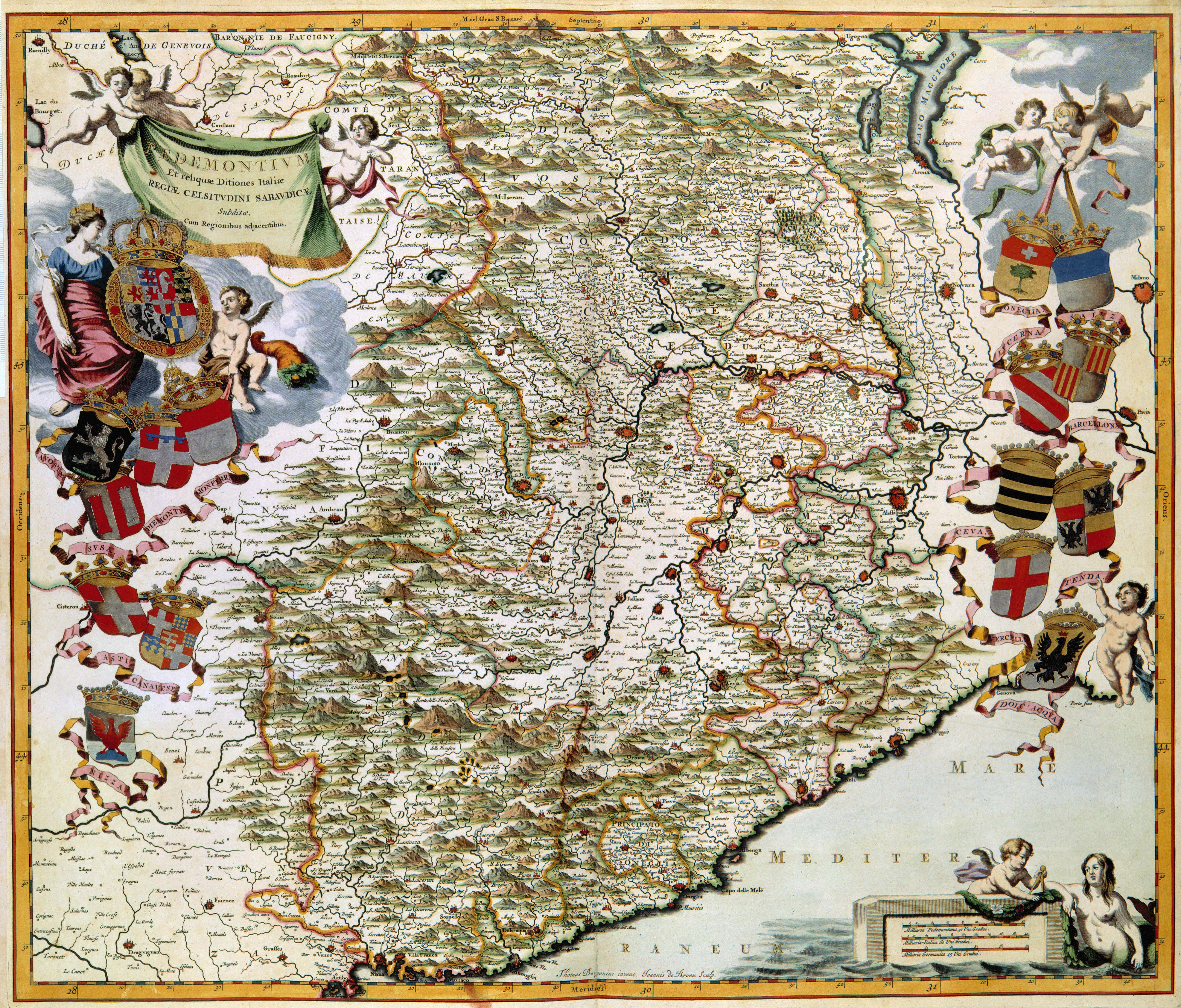
PEDEMONTIVM Et reliquae Ditionesssss Italiae REGIAE CELSITVDINI SABAVDICAE Subditae Cum Regionibus adjacentibus |
|||||||||||||||||||||||||||||||||||||||||||
| Object type | map | |||||||||||||||||||||||||||||||||||||||||||
| Description |
Nederlands: Deze kaart van Piemonte werd in 1682 gepubliceerd in het vierde deel van het stedenboek van Italie dat de erfgenamen van Joan Blaeu in dat jaar publiceerden. Dit gehele deel was gewijd aan de steden van Piemonte. Voor het graveren van deze kaart was de graveur Joannes de Broen (1649-ca. 1730) aangetrokken. Hij maakte daarbij gebruik van een grote overzichtskaart van de landstreek Savoye-Piemonte die de Italiaanse kartograaf Giovanni Thomaso Borgonio (ca. 1620-1684) in 1680 had vervaardigd.
English: In 1682 the heirs of Joan Blaeu published the fourth and fifth volume of the Town books of Italy. These concluded the series published since 1663. This map of Piemonte, an engraving by Joannes de Broen (1649-c. 1730) was included in the fifth volume dedicated to the cities of Piemonte. De Broen used a general map of Savoye-Piemonte which was published in 1680 from the Italian cartographer Giovanni Thomaso Borgonio (c. 1620-1684). |
|||||||||||||||||||||||||||||||||||||||||||
| Language |
Dutch |
|||||||||||||||||||||||||||||||||||||||||||
| Date | 1682 | |||||||||||||||||||||||||||||||||||||||||||
| Publication date |
circa |
|||||||||||||||||||||||||||||||||||||||||||
| Medium |
Nederlands: kopergravure
English: copper engraving print |
|||||||||||||||||||||||||||||||||||||||||||
| Dimensions | 51 x 60 cm | |||||||||||||||||||||||||||||||||||||||||||
| Collection |
|
|||||||||||||||||||||||||||||||||||||||||||
| Accession number |
Description of the Atlas Van der Hagen in the catalogue of the KB: http://opc4.kb.nl/DB=1/TTL=1/LNG=EN/PPN?PPN=353012750 |
|||||||||||||||||||||||||||||||||||||||||||
| Place of creation | Amsterdam | |||||||||||||||||||||||||||||||||||||||||||
| Notes | KW1049B12_053 - Volume 1 | |||||||||||||||||||||||||||||||||||||||||||
| Related persons | Borgonio, Giovanni Thomaso - Blaeu, Erfgenamen van Joan - Broen, Joannes de - Joan Blaeu | |||||||||||||||||||||||||||||||||||||||||||
| Depicted locations | Piemonte - Italy | |||||||||||||||||||||||||||||||||||||||||||
| References | ||||||||||||||||||||||||||||||||||||||||||||
| Source/Photographer |
Source page at the Geheugen van Nederland / Memory of the Netherlands website.
|
|||||||||||||||||||||||||||||||||||||||||||
| Permission (Reusing this file) |
|
|||||||||||||||||||||||||||||||||||||||||||
.jpg)

File history
Click on a date/time to view the file as it appeared at that time.
| Date/Time | Thumbnail | Dimensions | User | Comment | |
|---|---|---|---|---|---|
| current | 05:56, 18 July 2015 | | 5,500 × 4,697 (4.22 MB) | OlafJanssen (talk | contribs) | GWToolset: Creating mediafile for OlafJanssen. |
You cannot overwrite this file.
File usage on Commons
The following 4 pages use this file: