File:Atlas Van der Hagen-KW1049B11 096-ULTRAIECTINI DOMINI TABULA Multo aliis auctior et correctior.jpeg
Jump to navigation
Jump to search

Size of this preview: 729 × 600 pixels. Other resolutions: 292 × 240 pixels | 583 × 480 pixels | 933 × 768 pixels | 1,244 × 1,024 pixels | 2,489 × 2,048 pixels | 5,500 × 4,526 pixels.
Original file (5,500 × 4,526 pixels, file size: 4.26 MB, MIME type: image/jpeg)
Captions
Captions
Add a one-line explanation of what this file represents
Summary
[edit]| Dirk Jansz van Santen: Atlas van Dirk van der Hagen (volledig, collectie KB)
|
||||||||||||||||||||||||||||||||||||||||||||||||||||
|---|---|---|---|---|---|---|---|---|---|---|---|---|---|---|---|---|---|---|---|---|---|---|---|---|---|---|---|---|---|---|---|---|---|---|---|---|---|---|---|---|---|---|---|---|---|---|---|---|---|---|---|---|
| Artist |
Author: per Nic: Visscher R. de Hooghe fecit Publisher:
|
 | ||||||||||||||||||||||||||||||||||||||||||||||||||
| Author |
Author: per Nic: Visscher R. de Hooghe fecit Publisher:
|
|||||||||||||||||||||||||||||||||||||||||||||||||||
| Title |
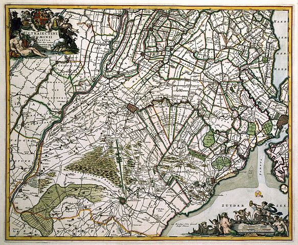
ULTRAIECTINI DOMINI TABULA Multo aliis auctior et correctior |
|||||||||||||||||||||||||||||||||||||||||||||||||||
| Object type | map | |||||||||||||||||||||||||||||||||||||||||||||||||||
| Description |
Nederlands: Het uitgevershuis Visscher deed voor het graveer- en tekenwerk ten behoeve van nieuwe uitgaven een beroep op de beste graveurs in Nederland. Daartoe behoorde de Haarlemse graveur Romeyn de Hooghe (1645-1708). Hij verzorgde een groot aantal kaarten, historie- en tuinprenten voor de firma, allen van hoge kwaliteit. Ook deze kaart van de provincie Utrecht is het resultaat van de succesvolle samenwerking tussen graveur en uitgever. Omdat uit de titel blijkt dat deze atlaskaart aanzienlijk is bijgewerkt en gecorrigeerd is het waarschijnlijk dat deze kaart is gebaseerd op een overzichtskaart van Holland en Utrecht door Balthasar Florisz van Berckenrode (1591/92-1644) die in 1621 door Willem Jansz. Blaeu werd uitgegeven. Deze wandkaart werd in 1651, 1656 en 1682 door de firma Visscher opnieuw uitgegeven. In 1696 verscheen bij
Nicolaes Visscher II (1649-1702) een nieuwe wandkaart van Utrecht van hand van de Utrechtse landmeter Bernard de Roy.
English: Commissioned by Nicolaes Visscher II (1649-1702) the best artists in the Netherlands carried out much work for him as engravers and designers for the purpose of new editions. One of them was Romeyn de Hooghe (1645-1708) from the town of Haarlem. He carried out many high quality maps, historical, and garden prints for Visscher. This map of the province of Utrecht is the result of a successful cooperation between engraver and publisher. According to the title, the map is adapted and corrected and is probable based on a general map of Holland and Utrecht by Balthasar Florisz van Berckenrode (1591/92-1644) published in 1621 by Willem Jansz. Blaeu. This wall map was reissued in 1651, 1656 and 1682 by Visscher. In 1696, Nicolaes Visscher II published a new wall map of Utrecht by Bernard
de Roy, surveyor in Utrecht. |
|||||||||||||||||||||||||||||||||||||||||||||||||||
| Language |
Dutch |
|||||||||||||||||||||||||||||||||||||||||||||||||||
| Date | after 1681 | |||||||||||||||||||||||||||||||||||||||||||||||||||
| Publication date |
circa |
|||||||||||||||||||||||||||||||||||||||||||||||||||
| Medium |
Nederlands: kopergravure
English: copper engraving print |
|||||||||||||||||||||||||||||||||||||||||||||||||||
| Dimensions | 46,5 x 56 cm | |||||||||||||||||||||||||||||||||||||||||||||||||||
| Collection |
|
|||||||||||||||||||||||||||||||||||||||||||||||||||
| Accession number |
Description of the Atlas Van der Hagen in the catalogue of the KB: http://opc4.kb.nl/DB=1/TTL=1/LNG=EN/PPN?PPN=353012750 |
|||||||||||||||||||||||||||||||||||||||||||||||||||
| Place of creation | Amsterdam | |||||||||||||||||||||||||||||||||||||||||||||||||||
| Notes | KW1049B11_096 - Volume 1 | |||||||||||||||||||||||||||||||||||||||||||||||||||
| Related persons | Romeyn de Hooghe - Balthasar Florisz van Berckenrode - Roy, Bernard de - Willem Jansz. Blaeu - Nicolaes Visscher II | |||||||||||||||||||||||||||||||||||||||||||||||||||
| Depicted locations | Utrecht (province) - Netherlands | |||||||||||||||||||||||||||||||||||||||||||||||||||
| References | ||||||||||||||||||||||||||||||||||||||||||||||||||||
| Source/Photographer |
Source page at the Geheugen van Nederland / Memory of the Netherlands website.
|
|||||||||||||||||||||||||||||||||||||||||||||||||||
| Permission (Reusing this file) |
|
|||||||||||||||||||||||||||||||||||||||||||||||||||

File history
Click on a date/time to view the file as it appeared at that time.
| Date/Time | Thumbnail | Dimensions | User | Comment | |
|---|---|---|---|---|---|
| current | 11:17, 18 July 2015 | | 5,500 × 4,526 (4.26 MB) | OlafJanssen (talk | contribs) | GWToolset: Creating mediafile for OlafJanssen. |
You cannot overwrite this file.
File usage on Commons
The following 3 pages use this file: