File:Atlas Van der Hagen-KW1049B10 026-LAPPONIA.jpeg
Jump to navigation
Jump to search
Size of this preview: 746 × 600 pixels. Other resolutions: 299 × 240 pixels | 597 × 480 pixels | 956 × 768 pixels | 1,274 × 1,024 pixels | 2,548 × 2,048 pixels | 5,500 × 4,421 pixels.
Original file (5,500 × 4,421 pixels, file size: 3.6 MB, MIME type: image/jpeg)
Captions
Captions
Add a one-line explanation of what this file represents
Summary
[edit]| Dirk Jansz van Santen: Atlas van Dirk van der Hagen (volledig, collectie KB)
|
||||||||||||||||||||||||||||
|---|---|---|---|---|---|---|---|---|---|---|---|---|---|---|---|---|---|---|---|---|---|---|---|---|---|---|---|---|
| Artist |
Andrea Buraeo Sueco Author: Andrea Buraeo Sueco Publisher:
|
 | ||||||||||||||||||||||||||
| Title |
LAPPONIA |
|||||||||||||||||||||||||||
| Object type | map | |||||||||||||||||||||||||||
| Description |
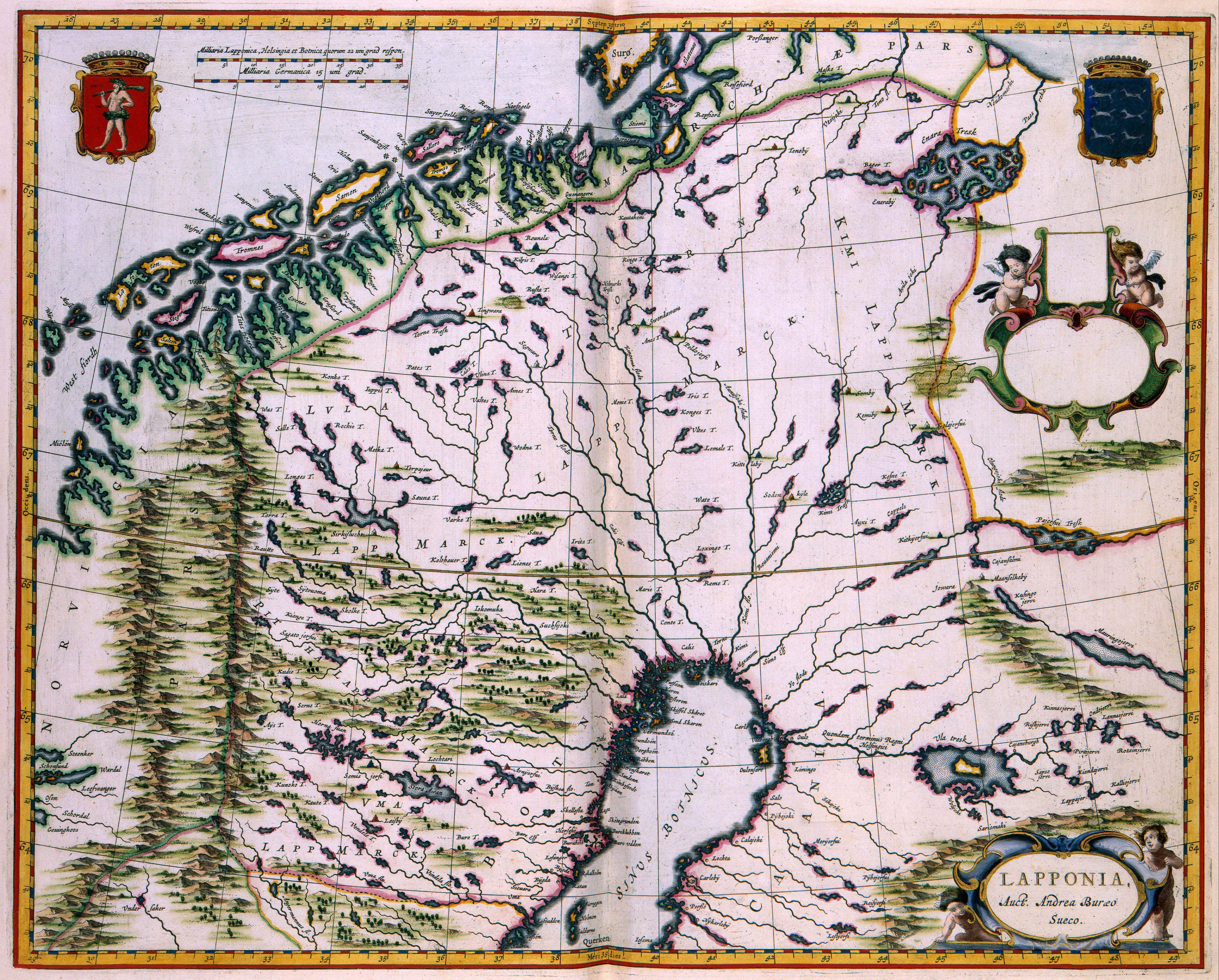
Nederlands: Het zeer uitgestrekte en ruige Lapland gold lange tijd als een ontoegankelijk en alleen door nomaden bevolkt terrein. Hoewel het gebied oorspronkelijk tot Noorwegen behoorde, werd Lapland in de 17de eeuw door de Zweden gekoloniseerd en ook geannexeerd. In de voetsporen van de kolonisten volgden ook de landmeters en kartografen die het gebied stukje bij beetje in kaart brachten. Een van hen was Anders Bureus (1571-1661) die in Zweden belast was met het samenstellen van een kaart van het Zweedse rijk. Die opmetingen resulteerden uiteindelijk in deze kaart die voor het eerst in 1662 door Joan Blaeu (1598-1673) werd gepubliceerd.
English: The very extensive and rough Lappland was considered for a long time inaccessible territory and was only inhabited by nomads. Although the territory originally belonged to Norway, Lappland was colonized and annexed in the 17th century by Sweden. After the colonizers followed the surveyors and cartographers who mapped the country bit by bit. One of them was the Swedish surveyor and mathematician Anders Bureus (1571-1661), who was in charge of the compilation of a large survey map of Sweden. This map was published for the first time in 1662 by Joan Blaeu (1598-1673) in his Atlas Maior. |
|||||||||||||||||||||||||||
| Language |
Dutch |
|||||||||||||||||||||||||||
| Date | 1662 | |||||||||||||||||||||||||||
| Publication date |
circa |
|||||||||||||||||||||||||||
| Medium |
Nederlands: kopergravure
English: copper engraving print |
|||||||||||||||||||||||||||
| Dimensions | 41,5 x 51 cm | |||||||||||||||||||||||||||
| Collection |
|
|||||||||||||||||||||||||||
| Accession number |
Description of the Atlas Van der Hagen in the catalogue of the KB: http://opc4.kb.nl/DB=1/TTL=1/LNG=EN/PPN?PPN=353012750 |
|||||||||||||||||||||||||||
| Place of creation | Amsterdam | |||||||||||||||||||||||||||
| Notes | KW1049B10_026 - Volume 1 | |||||||||||||||||||||||||||
| Related persons | Joan Blaeu - Anders Bureus | |||||||||||||||||||||||||||
| Depicted locations | Norway - Sweden - Lappland | |||||||||||||||||||||||||||
| References | ||||||||||||||||||||||||||||
| Source/Photographer |
Source page at the Geheugen van Nederland / Memory of the Netherlands website.
|
|||||||||||||||||||||||||||
| Permission (Reusing this file) |
|
|||||||||||||||||||||||||||
.jpg)

File history
Click on a date/time to view the file as it appeared at that time.
| Date/Time | Thumbnail | Dimensions | User | Comment | |
|---|---|---|---|---|---|
| current | 07:16, 19 July 2015 | | 5,500 × 4,421 (3.6 MB) | OlafJanssen (talk | contribs) | GWToolset: Creating mediafile for OlafJanssen. |
You cannot overwrite this file.
File usage on Commons
The following 4 pages use this file: