File:Atlas Beudeker-C9E10 115 25F-OBSIDIO RHINBERCAE ad vivum expressa cum suis dimensi.....jpeg
Jump to navigation
Jump to search

Size of this preview: 703 × 600 pixels. Other resolutions: 281 × 240 pixels | 563 × 480 pixels | 900 × 768 pixels | 1,200 × 1,024 pixels | 2,400 × 2,048 pixels | 5,500 × 4,693 pixels.
Original file (5,500 × 4,693 pixels, file size: 6.01 MB, MIME type: image/jpeg)
Captions
Captions
Add a one-line explanation of what this file represents
Summary
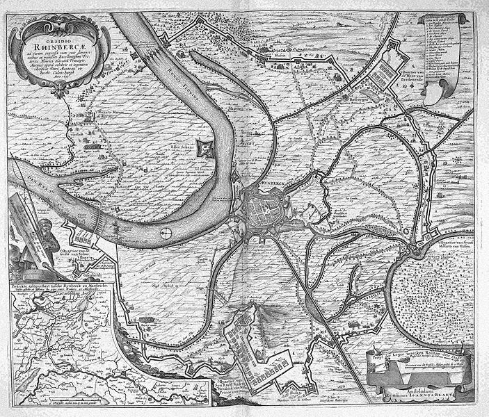
[edit]| OBSIDIO RHINBERCAE ad vivum expressa cum suis dimensi....
( |
||||||
|---|---|---|---|---|---|---|
| Artist |
Petri Manteau et Iacobi Culen-burgh Anno 1633 |
|||||
| Author |
Author: Petri Manteau et Iacobi Culen-burgh Anno 1633 Publisher: Ex officina Ioannis Blaev |
|||||
| Title |
OBSIDIO RHINBERCAE ad vivum expressa cum suis dimensi.... |
|||||
| Object type | map | |||||
| Description |
Nederlands: De belegering van de Duitse vesting Rheinberg door een Nederlandse legermacht onder Frederik Hendrik werd in 1633 uitgegeven gekarteerd door de Nerlandse militaire ingenieurs Pieter Manteau van Dalem (1607-1688) en Jacob Culenburgh. De kaart werd nog in datzelfde jaart uitgegeven door Claes Jansz. Visscher (1587-1652). Later kwam de koperplaat in handen van Joan Blaeu (1596-1673) die nadat hij de naam van Visscher door zijn eigen naam had vervangen, de kaart opnieuw afdrukte in het eerste deel van zijn stedenboek uit 1649. Linksonder een inzetkaart: Perfeckte Gelegentheyt tussche Rynberck en Maestricht .. Rechtsonder: Profyl der leger wercken Rontom dese Stadt ..
English: This map depicting the siege of the German fortress Rheinberg by a Dutch army led by Frederik Hendrik was created by the Dutch military engineers Pieter Manteau van Dalem(1607-1688) and Jacob Culenburgh in 1633. In the same year, the map was published by Claes Jansz. Visscher (1587-1652). The copperplate was later purchased by Joan Blaeu (1596-1673) who altered Visschers name into his own and published the map in the first volume of his Town Books of the Netherlands from 1649. |
|||||
| Medium |
Nederlands: Kopergravure
English: copper engraving print |
|||||
| Dimensions | 46,5 x 56 cm | |||||
| Collection | ||||||
| Notes | C9E10 115_25F | |||||
| Related persons | Claes Jansz. Visscher - Joan Blaeu - Frederick Henry, Prince of Orange - Pieter Manteau van Dalem - Jacob Culenburgh | |||||
| Depicted locations | Germany - Rheinberg | |||||
| Source/Photographer |
Source page at the Geheugen van Nederland / Memory of the Netherlands website
|
|||||
| Permission (Reusing this file) |
|
|||||


File history
Click on a date/time to view the file as it appeared at that time.
| Date/Time | Thumbnail | Dimensions | User | Comment | |
|---|---|---|---|---|---|
| current | 13:21, 16 July 2015 | | 5,500 × 4,693 (6.01 MB) | OlafJanssen (talk | contribs) | GWToolset: Creating mediafile for OlafJanssen. |
You cannot overwrite this file.
File usage on Commons
The following page uses this file: