File:Atlantic coasts of Europe, Norway to Finisterre RMG K0961.jpg

Original file (939 × 1,280 pixels, file size: 1.36 MB, MIME type: image/jpeg)
Captions
Captions
Summary
[edit]| Author |
Nicholas Comberford |
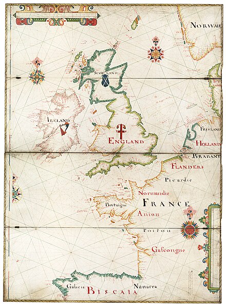
| Description |
English: [Atlantic coasts of Europe, Norway to Finisterre] Two sheets joined. Hand coloured manuscript drawn on vellum, mounted on four hinged oak boards, each 79 x 27cm. The scale is in English leagues. The border is graduated for latitude. Soundings are shown in the south-west approaches, the Channel, North Sea and the Bay of Biscay. Heraldic shields feature on England, Scotland and Ireland. Made by Nicholas Comberford dwelling at the Signe of the Platt neare the west end of the schoole house in Ratcliffe anno 1666. Nicholas Comberford was a leading member of the Thames School of chart makers who drew manuscript plane charts on vellum. |
| Date | 1666 |
| Dimensions | 78 x 107.5cm. |
| Source/Photographer | http://collections.rmg.co.uk/collections/objects/540270 |
| Permission (Reusing this file) |
The original artefact or artwork has been assessed as public domain by age, and faithful reproductions of the two dimensional work are also public domain. No permission is required for reuse for any purpose. The text of this image record has been derived from the Royal Museums Greenwich catalogue and image metadata. Individual data and facts such as date, author and title are not copyrightable, but reuse of longer descriptive text from the catalogue may not be considered fair use. Reuse of the text must be attributed to the "National Maritime Museum, Greenwich, London" and a Creative Commons CC-BY-NC-SA-3.0 license may apply if not rewritten. Refer to Royal Museums Greenwich copyright. |
| Other versions |
|
| Identifier | Acquisition Number: N48-331A. id number: G215:1/3 |
| Collection | Charts and maps |

Licensing
[edit]
|
This is a faithful photographic reproduction of a two-dimensional, public domain work of art. The work of art itself is in the public domain for the following reason:
The official position taken by the Wikimedia Foundation is that "faithful reproductions of two-dimensional public domain works of art are public domain".
This photographic reproduction is therefore also considered to be in the public domain in the United States. In other jurisdictions, re-use of this content may be restricted; see Reuse of PD-Art photographs for details. | ||||
File history
Click on a date/time to view the file as it appeared at that time.
| Date/Time | Thumbnail | Dimensions | User | Comment | |
|---|---|---|---|---|---|
| current | 08:39, 12 September 2017 | | 939 × 1,280 (1.36 MB) | Fæ (talk | contribs) | Royal Museums Greenwich Charts and maps, http://collections.rmg.co.uk/collections/objects/540270 #2973-1 |
You cannot overwrite this file.
File usage on Commons
The following 4 pages use this file:
_RMG_K0961.jpg&redirect=no)