File:At Diamer, nearing Babusar pass via N15 motorway 01.jpg
![File:At Diamer, nearing Babusar pass via N15 motorway 01.jpg](https://upload.wikimedia.org/wikipedia/commons/thumb/d/df/At_Diamer%2C_nearing_Babusar_pass_via_N15_motorway_01.jpg/800px-At_Diamer%2C_nearing_Babusar_pass_via_N15_motorway_01.jpg?20180530053845)
Original file (2,048 × 1,152 pixels, file size: 1.61 MB, MIME type: image/jpeg)
Captions
Captions
Summary
[edit]DescriptionAt Diamer, nearing Babusar pass via N15 motorway 01.jpg |
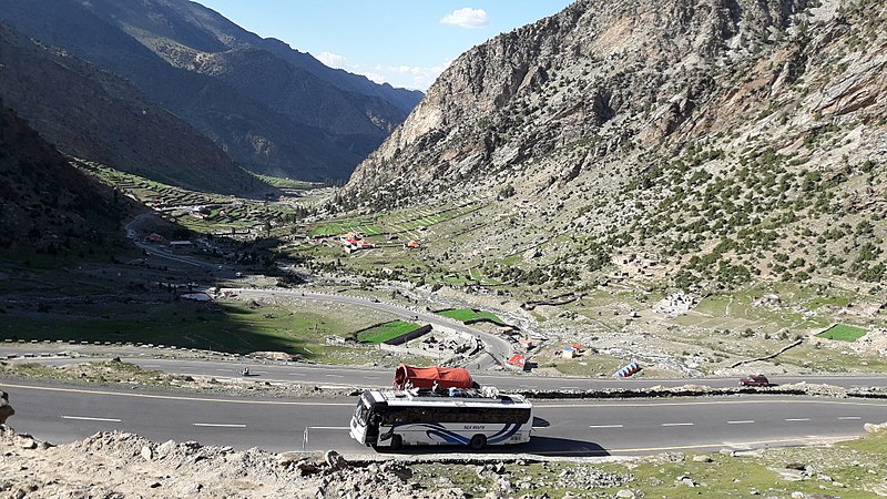
English: Since the development of N15 the highway/motorway, connectivity between valleys of Kaghan/Naran & Kohistan/Diamer; has greatly improved. N15 has created a marvelous shortcut by efficiently surmounting the major hurdle of Babusar pass, previously the tough one to cross particularly in winters.
The more tourist friendly (Hotels, resorts etc) N15 has become a more popular alternative to the great & famous KKH (Karakoram Highway) |
Date | |
Source | Own work |
Author | Ghazala Shah |
Camera location | 35° 11′ 24″ N, 74° 02′ 35″ E ![]() ![]() | View this and other nearby images on: OpenStreetMap | ![]() |
---|
Licensing
[edit]![w:en:Creative Commons](https://upload.wikimedia.org/wikipedia/commons/thumb/7/79/CC_some_rights_reserved.svg/90px-CC_some_rights_reserved.svg.png)
![attribution](https://upload.wikimedia.org/wikipedia/commons/thumb/1/11/Cc-by_new_white.svg/24px-Cc-by_new_white.svg.png)
![share alike](https://upload.wikimedia.org/wikipedia/commons/thumb/d/df/Cc-sa_white.svg/24px-Cc-sa_white.svg.png)
- You are free:
- to share – to copy, distribute and transmit the work
- to remix – to adapt the work
- Under the following conditions:
- attribution – You must give appropriate credit, provide a link to the license, and indicate if changes were made. You may do so in any reasonable manner, but not in any way that suggests the licensor endorses you or your use.
- share alike – If you remix, transform, or build upon the material, you must distribute your contributions under the same or compatible license as the original.
![]() |
This image was uploaded as part of Wiki Loves Earth 2018.
aragonés | العربية | asturianu | azərbaycanca | беларуская (тарашкевіца) | български | বাংলা | brezhoneg | català | čeština | Cymraeg | Deutsch | Ελληνικά | English | español | eesti | euskara | فارسی | français | galego | עברית | hrvatski | հայերեն | Bahasa Indonesia | italiano | 日本語 | ქართული | 한국어 | latviešu | македонски | മലയാളം | मराठी | Bahasa Melayu | norsk bokmål | नेपाली | Nederlands | norsk | polski | português | português do Brasil | русский | sicilianu | shqip | slovenščina | српски / srpski | svenska | ไทย | Türkçe | українська | اردو | 中文 | 中文(台灣) | +/− |
![]() |
File history
Click on a date/time to view the file as it appeared at that time.
Date/Time | Thumbnail | Dimensions | User | Comment | |
---|---|---|---|---|---|
current | 05:38, 30 May 2018 | ![]() | 2,048 × 1,152 (1.61 MB) | Ghazala Shah (talk | contribs) | User created page with UploadWizard |
You cannot overwrite this file.
File usage on Commons
There are no pages that use this file.
Metadata
This file contains additional information such as Exif metadata which may have been added by the digital camera, scanner, or software program used to create or digitize it. If the file has been modified from its original state, some details such as the timestamp may not fully reflect those of the original file. The timestamp is only as accurate as the clock in the camera, and it may be completely wrong.
Camera manufacturer | samsung |
---|---|
Camera model | SM-J710F |
Exposure time | 1/919 sec (0.0010881392818281) |
F-number | f/1.9 |
ISO speed rating | 40 |
Date and time of data generation | 16:38, 8 July 2017 |
Lens focal length | 3.7 mm |
Latitude | 35° 11′ 24″ N |
Longitude | 74° 2′ 35″ E |
Altitude | 3,080 meters above sea level |
Orientation | Normal |
Horizontal resolution | 72 dpi |
Vertical resolution | 72 dpi |
Software used | J710FXXU2AQB3 |
File change date and time | 16:38, 8 July 2017 |
Y and C positioning | Centered |
Exposure Program | Normal program |
Exif version | 2.2 |
Date and time of digitizing | 16:38, 8 July 2017 |
APEX shutter speed | 9.84 |
APEX aperture | 1.85 |
APEX brightness | 7.77 |
APEX exposure bias | 0 |
Maximum land aperture | 1.85 APEX (f/1.9) |
Metering mode | Center weighted average |
Flash | Flash did not fire |
DateTime subseconds | 0386 |
DateTimeOriginal subseconds | 0386 |
DateTimeDigitized subseconds | 0386 |
Supported Flashpix version | 1 |
Color space | sRGB |
Exposure mode | Auto exposure |
White balance | Auto white balance |
Focal length in 35 mm film | 28 mm |
Scene capture type | Standard |
Unique image ID | V13LLIA02AM V13LLJC06SB |
GPS time (atomic clock) | 11:30 |
GPS date | 8 July 2017 |
GPS tag version | 0.0.2.2 |
Structured data
Items portrayed in this file
depicts
35°11'24.000"N, 74°2'35.002"E
8 July 2017
0.00108813928182807399 second
1.9
3.7 millimetre
image/jpeg
e9a2c2fe0c75a62c74940c498b26f0a4b2d32746
1,683,817 byte
1,152 pixel
2,048 pixel
- Files with coordinates missing SDC location of creation
- CC-BY-SA-4.0
- Self-published work
- Images from Wiki Loves Earth 2018
- Images from Wiki Loves Earth 2018 in Pakistan
- Images from Wiki Loves Earth missing SDC depicts
- Images from Wiki Loves Earth missing SDC location of creation
- Uploaded via Campaign:wle-pk
- Pakistan photographs taken on 2017-07-08