File:Assyria map sr.svg
Jump to navigation
Jump to search

Size of this PNG preview of this SVG file: 800 × 569 pixels. Other resolutions: 320 × 227 pixels | 640 × 455 pixels | 1,024 × 728 pixels | 1,280 × 910 pixels | 2,560 × 1,820 pixels | 2,026 × 1,440 pixels.
Original file (SVG file, nominally 2,026 × 1,440 pixels, file size: 154 KB)
Captions
Captions
Add a one-line explanation of what this file represents
| Description |
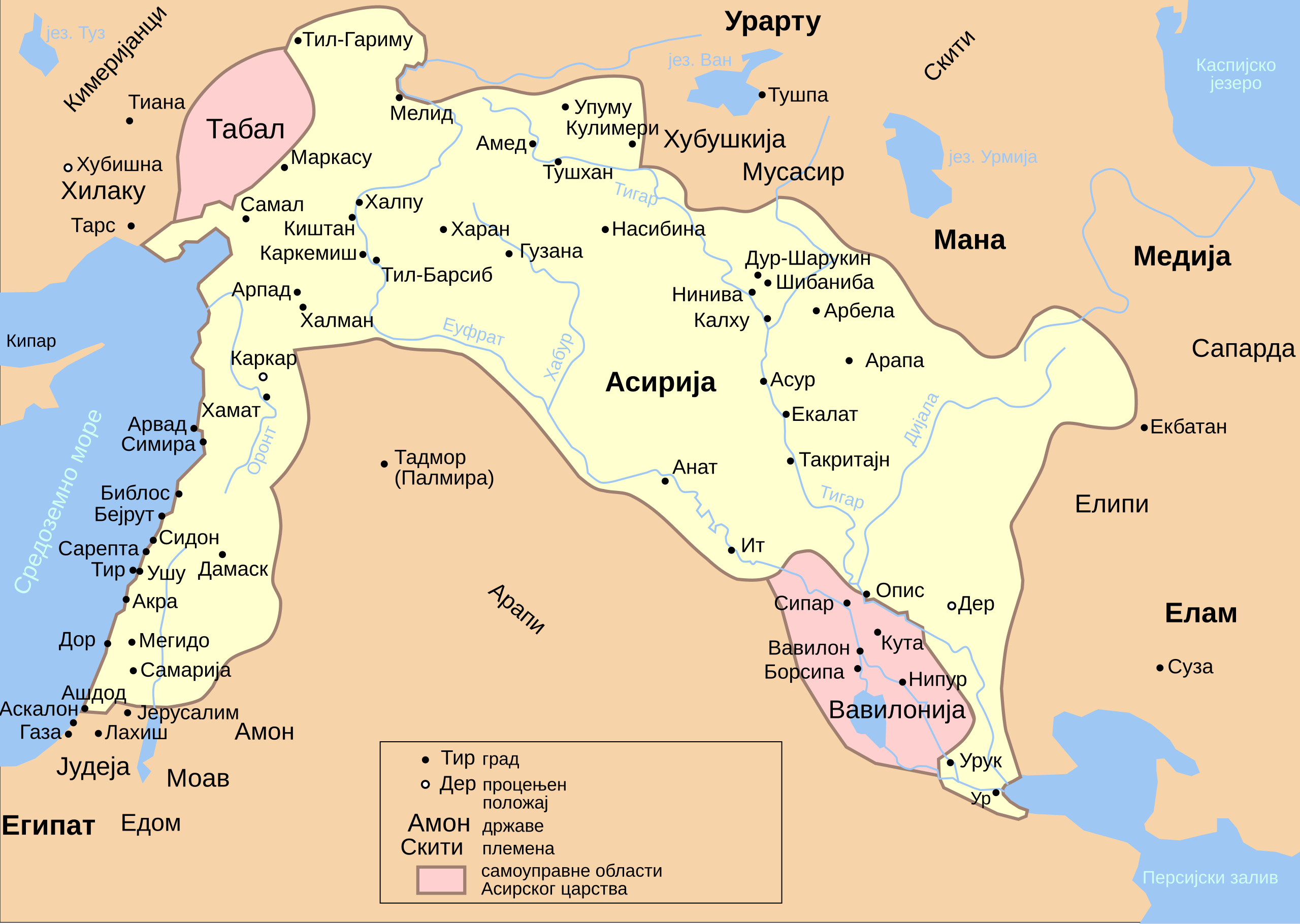
English: Map of Assyria about 654 BC Русский: Ассирийская держава около 654 г. до н. э. С помощью Inkscape. |
| Date | (UTC) |
| Source | |
| Author |
|
| This is a retouched picture, which means that it has been digitally altered from its original version. Modifications: translated to serbian. The original can be viewed here: Assyria map ru.svg:
|

|
This SVG file contains embedded text that can be translated into your language, using any capable SVG editor, text editor or the SVG Translate tool. For more information see: About translating SVG files. |
This file is licensed under the Creative Commons Attribution-Share Alike 3.0 Unported license.
- You are free:
- to share – to copy, distribute and transmit the work
- to remix – to adapt the work
- Under the following conditions:
- attribution – You must give appropriate credit, provide a link to the license, and indicate if changes were made. You may do so in any reasonable manner, but not in any way that suggests the licensor endorses you or your use.
- share alike – If you remix, transform, or build upon the material, you must distribute your contributions under the same or compatible license as the original.
Original upload log
[edit]
This image is a derivative work of the following images:
- File:Assyria_map_ru.svg licensed with Cc-by-sa-3.0, GFDL
- 2009-02-03T02:31:37Z Anton Gutsunaev 2026x1440 (158103 Bytes) Экбатаны=>Экбатана
- 2008-12-20T15:55:32Z Anton Gutsunaev 2026x1440 (138330 Bytes) сглаживание границ, Арбелы=>Арбела
- 2008-12-19T17:10:25Z Anton Gutsunaev 2026x1440 (136140 Bytes) племена наискосок
- 2008-12-16T19:31:48Z Anton Gutsunaev 2026x1440 (135924 Bytes) важнейшие государства жирным шрифтом
- 2008-12-16T19:21:03Z Anton Gutsunaev 2026x1440 (136017 Bytes) не получилось
- 2008-12-16T19:16:46Z Anton Gutsunaev 2026x1440 (136326 Bytes) Куту=>Кута, Мана=>Манна, крупнее шрифты у государств; Урарту, Элам, Манна, Мидия, Египет - ещё крупнее
- 2008-12-13T13:47:20Z Anton Gutsunaev 2026x1440 (136039 Bytes) increasing font for some cities
- 2008-12-13T13:28:02Z Anton Gutsunaev 2026x1440 (136037 Bytes) increasing font for cities
- 2008-12-09T21:06:16Z Anton Gutsunaev 2026x1440 (136031 Bytes) + 3 города, добавление в легенду
- 2008-12-08T18:16:07Z Anton Gutsunaev 2026x1440 (131168 Bytes) 3 государства были обозначены как племена
- 2008-12-08T03:46:28Z Anton Gutsunaev 2026x1440 (131432 Bytes) названия, подписи, сглаживание, легенда
- 2008-12-06T20:25:35Z Anton Gutsunaev 2026x1440 (103141 Bytes) {{Information |Description={{en|1=map of Assyria}} {{ru|1=карта Ассирии}} |Source=Own work by uploader |Author=[[User:Anton Gutsunaev|Anton Gutsunaev]] |Date=7 december 2008 |Permission= |other_versions= }}
Uploaded with derivativeFX
File history
Click on a date/time to view the file as it appeared at that time.
| Date/Time | Thumbnail | Dimensions | User | Comment | |
|---|---|---|---|---|---|
| current | 08:50, 24 August 2011 | | 2,026 × 1,440 (154 KB) | BokicaK (talk | contribs) | Мидија Медија |
| 06:42, 24 August 2011 |  | 2,026 × 1,440 (154 KB) | BokicaK (talk | contribs) | {{Information |Description={{en|1=Map of Assyria about 654 BC}} {{ru|1=Ассирийская держава около 654 г. до н. э. С помощью Inkscape.}} |Source=*File:Assyria_map_ru.svg |Date=2011-08-24 06:42 (UTC) |Author=*[[:File |
You cannot overwrite this file.
File usage on Commons
There are no pages that use this file.
File usage on other wikis
The following other wikis use this file:
- Usage on hy.wikipedia.org
- Usage on sr.wikipedia.org