File:AshfieldLocationMapSatelliteNASA.jpg
Jump to navigation
Jump to search

Size of this preview: 800 × 592 pixels. Other resolutions: 320 × 237 pixels | 640 × 473 pixels | 891 × 659 pixels.
Original file (891 × 659 pixels, file size: 327 KB, MIME type: image/jpeg)
Captions
Captions
Add a one-line explanation of what this file represents
Summary
[edit]
| Description |
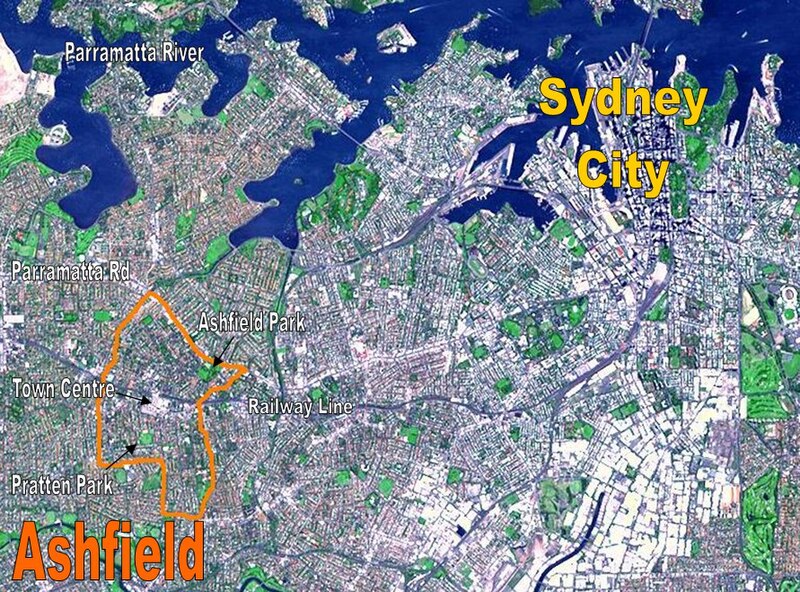
English: Location Map for the suburb of Ashfield, NSW based on NASA satellite map. Modified to identify suburb boundaries and identifiable landmarks. |
| Date | |
| Source | Based on http://photojournal.jpl.nasa.gov/catalog/PIA03498 |
| Author | NASA with adaptations by Crico at en.wikipedia |
Licensing
[edit]
| This file is in the public domain in the United States because it was solely created by NASA. NASA copyright policy states that "NASA material is not protected by copyright unless noted". (See Template:PD-USGov, NASA copyright policy page or JPL Image Use Policy.) | ||
 |
Warnings:
|
Original upload log
[edit]
The original description page was here. All following user names refer to en.wikipedia.
- 2007-03-13 04:28 Crico 891×659× (334802 bytes) Location Map for the suburb of Ashfield, NSW based on NASA satellite map. Modified to identify suburb boundaries and identifiable landmarks. Original NASA image number: [[:Image:PIA03498.jpg|PIA03498]] {{PD-USGov-NASA}}
File history
Click on a date/time to view the file as it appeared at that time.
| Date/Time | Thumbnail | Dimensions | User | Comment | |
|---|---|---|---|---|---|
| current | 23:12, 28 February 2009 | | 891 × 659 (327 KB) | File Upload Bot (Magnus Manske) (talk | contribs) | {{BotMoveToCommons|en.wikipedia|year={{subst:CURRENTYEAR}}|month={{subst:CURRENTMONTHNAME}}|day={{subst:CURRENTDAY}}}} {{Information |Description={{en|Location Map for the suburb of Ashfield, NSW based on NASA satellite map. Modified to identify suburb b |
You cannot overwrite this file.
File usage on Commons
There are no pages that use this file.
File usage on other wikis
The following other wikis use this file:
- Usage on en.wikipedia.org