File:Ashcombe Road, Kingswood - geograph.org.uk - 538353.jpg
Jump to navigation
Jump to search
Size of this preview: 450 × 600 pixels. Other resolutions: 180 × 240 pixels | 480 × 640 pixels.
Original file (480 × 640 pixels, file size: 109 KB, MIME type: image/jpeg)
Captions
Captions
Add a one-line explanation of what this file represents
Summary
[edit]
| Description |
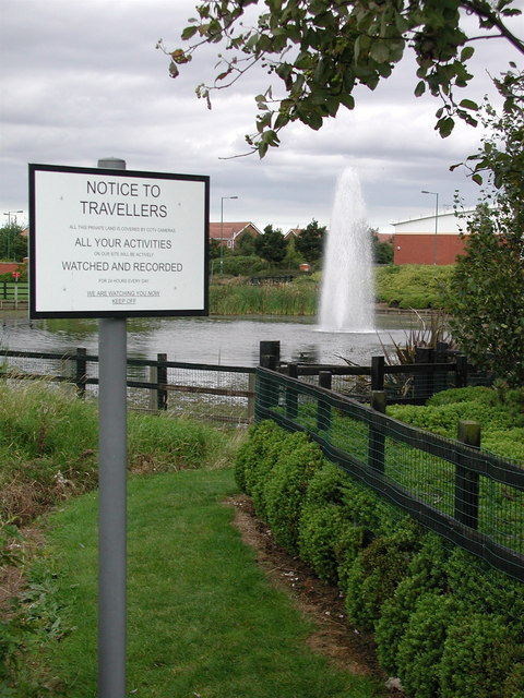
English: Ashcombe Road, Kingswood, Hull, East Riding of Yorkshire, England. The area formerly known as 'Grey Legs' east of the River Hull is now a development site with the not quite so interesting name of Kingston Parks. Signs such as the one pictured have been placed at regular intervals around every unused patch of land. The rather less-than-polite notice reads: NOTICE TO TRAVELLERS ALL THIS PRIVATE LAND IS COVERED BY CCTV CAMERAS. ALL YOUR ACTIVITIES ON OUR SITE WILL BE ACTIVELY WATCHED AND RECORDED FOR 24 HOURS EVERY DAY. WE ARE WATCHING YOU NOW KEEP OFF |
| Date | |
| Source | From geograph.org.uk |
| Author | Paul Glazzard |
| Permission (Reusing this file) |
Creative Commons Attribution Share-alike license 2.0 |
| Attribution (required by the license) | Paul Glazzard / Ashcombe Road, Kingswood / |
| Camera location | | View this and other nearby images on: OpenStreetMap |
|---|
_heading:22.00&language=en)
| Object location | | View this and other nearby images on: OpenStreetMap |
|---|
_heading:22.00&language=en)
Licensing
[edit]

|
This image was taken from the Geograph project collection. See this photograph's page on the Geograph website for the photographer's contact details. The copyright on this image is owned by Paul Glazzard and is licensed for reuse under the Creative Commons Attribution-ShareAlike 2.0 license.
|
This file is licensed under the Creative Commons Attribution-Share Alike 2.0 Generic license.
Attribution: Paul Glazzard
- You are free:
- to share – to copy, distribute and transmit the work
- to remix – to adapt the work
- Under the following conditions:
- attribution – You must give appropriate credit, provide a link to the license, and indicate if changes were made. You may do so in any reasonable manner, but not in any way that suggests the licensor endorses you or your use.
- share alike – If you remix, transform, or build upon the material, you must distribute your contributions under the same or compatible license as the original.
File history
Click on a date/time to view the file as it appeared at that time.
| Date/Time | Thumbnail | Dimensions | User | Comment | |
|---|---|---|---|---|---|
| current | 19:08, 5 February 2011 | | 480 × 640 (109 KB) | GeographBot (talk | contribs) | == {{int:filedesc}} == {{Information |description={{en|1=Ashcombe Road, Kingswood The area formerly known as 'Grey Legs' east of the River Hull is now a development site with the not quite so interesting name of Kingston Parks. Signs such as the one pictu |
You cannot overwrite this file.
File usage on Commons
There are no pages that use this file.