File:Ash Plume from Tavurvur, Papua New Guinea.jpg
Jump to navigation
Jump to search

Size of this preview: 534 × 599 pixels. Other resolutions: 214 × 240 pixels | 428 × 480 pixels | 685 × 768 pixels | 1,183 × 1,327 pixels.
Original file (1,183 × 1,327 pixels, file size: 241 KB, MIME type: image/jpeg)
Captions
Captions
Add a one-line explanation of what this file represents
Summary
[edit]
| Description |
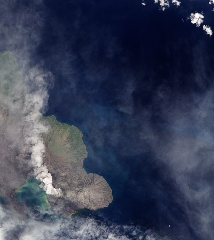
English: A 1994 eruption which buried Rabaul involved the currently active Tavurvur Cone as well as Vulcan Cone, located across Blanche Bay to the south-west (not pictured). The city of Rabaul is located on the peninsula across the Great Harbor from Tavurvur. More than a foot of ash fell on parts of the city, and combined with rain, it collapsed many of the small city’s buildings and houses. White dots on the peninsula may be buildings or building sites. |
| Date | |
| Source | NASA Earth Observatory |
| Author | Robert Simmon |
Image captured by the Advanced Land Imager on NASA’s Earth Observing-1 (EO-1) satellite. Image created using EO-1 ALI data provided by the NASA EO-1 team. Instrument: EO-1 - ALI
Licensing
[edit]
| This file is in the public domain in the United States because it was solely created by NASA. NASA copyright policy states that "NASA material is not protected by copyright unless noted". (See Template:PD-USGov, NASA copyright policy page or JPL Image Use Policy.) | ||
 |
Warnings:
|
| Annotations | This image is annotated: View the annotations at Commons |
File history
Click on a date/time to view the file as it appeared at that time.
| Date/Time | Thumbnail | Dimensions | User | Comment | |
|---|---|---|---|---|---|
| current | 13:04, 8 December 2009 | | 1,183 × 1,327 (241 KB) | Originalwana (talk | contribs) | {{Information |Description={{en|1=A 1994 eruption which buried Rabaul involved the currently active Tavurvur Cone as well as Vulcan Cone, located across Blanche Bay to the south-west (not pictured). The city of Rabaul is located on the peninsula acros |
You cannot overwrite this file.
File usage on Commons
The following page uses this file:
File usage on other wikis
The following other wikis use this file:
- Usage on br.wikipedia.org
- Usage on en.wikipedia.org
- Usage on fa.wikipedia.org
- Usage on hu.wikipedia.org
- Usage on id.wikipedia.org
- Usage on it.wikipedia.org
- Usage on ja.wikipedia.org
- Usage on ko.wikipedia.org
- Usage on pt.wikipedia.org
- Usage on uk.wikipedia.org
- Usage on zh.wikipedia.org