File:Artillery Lake, Northwest Territories map 01.jpg

Original file (787 × 727 pixels, file size: 452 KB, MIME type: image/jpeg)
Captions
Captions
Summary
[edit]| Description |
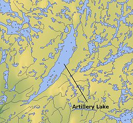
English: {| border-spacing:8px; style="width:100%; clear:both; margin:0.5em auto; background-color:var(--background-color-neutral-subtle,#f7f8ff); border:2px solid #8888aa;color: inherit;" lang="en" dir="ltr" class="layouttemplate restrictiontemplate "
| style="border:none;" | This map image could be re-created using vector graphics as an SVG file. This has several advantages; see Commons:Media for cleanup for more information. If an SVG form of this image is available, please upload it and afterwards replace this template with
|}
{{vector version available|new image name}}.
It is recommended to name the SVG file “Artillery Lake, Northwest Territories map 01.svg”—then the template Vector version available (or Vva) does not need the new image name parameter.
LicensingThis screenshot either does not contain copyright-eligible parts or visuals of copyrighted software, or the author has released it under a free license (which should be indicated beneath this notice), and as such follows the licensing guidelines for screenshots of Wikimedia Commons. You may use it freely according to its particular license. Free software license:
Note: if the screenshot shows any work that is not a direct result of the program code itself, such as a text or graphics that are not part of the program, the license for that work must be indicated separately. LicensingThis file is licensed under the Creative Commons Attribution 3.0 Unported license.
|
||||||||||||
| Date |
|
||||||||||||
| Source | http://www.maps-for-free.com/ | ||||||||||||
| Author | http://www.maps-for-free.com/ | ||||||||||||
| Permission (Reusing this file) |
This file is licensed under the Creative Commons Attribution 3.0 Unported license.
|


Licensing
[edit]

|
Permission is granted to copy, distribute and/or modify this document under the terms of the GNU Free Documentation License, Version 1.2 or any later version published by the Free Software Foundation; with no Invariant Sections, no Front-Cover Texts, and no Back-Cover Texts. A copy of the license is included in the section entitled GNU Free Documentation License. |
- You are free:
- to share – to copy, distribute and transmit the work
- to remix – to adapt the work
- Under the following conditions:
- attribution – You must give appropriate credit, provide a link to the license, and indicate if changes were made. You may do so in any reasonable manner, but not in any way that suggests the licensor endorses you or your use.
File history
Click on a date/time to view the file as it appeared at that time.
| Date/Time | Thumbnail | Dimensions | User | Comment | |
|---|---|---|---|---|---|
| current | 13:03, 30 March 2011 | | 787 × 727 (452 KB) | Anna Frodesiak (talk | contribs) | {{Information |Description ={{en|1={{convert to SVG|map}} {{Information |Description=Artillery Lake, Northwest Territories, Canada - locator map |Source=http://www.maps-for-free.com/ |Date=2011-03-30 |Author=Modified by Anna Frodesiak |Permission=http: |
You cannot overwrite this file.
File usage on Commons
There are no pages that use this file.
File usage on other wikis
The following other wikis use this file:
- Usage on bg.wikipedia.org
- Usage on cs.wikipedia.org
- Usage on en.wikipedia.org
- Usage on fr.wikipedia.org
- Usage on pt.wikipedia.org
- Usage on zh.wikipedia.org