File:Artemisa mapa.jpg
Jump to navigation
Jump to search
No higher resolution available.
Artemisa_mapa.jpg (600 × 397 pixels, file size: 40 KB, MIME type: image/jpeg)
Captions
Captions
Add a one-line explanation of what this file represents
Summary
[edit]
| Description |
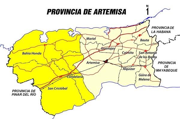
English: Map of Artemisa Province in Cuba, showing main roads, railways and municipalities
Español: Mapa de la Provincia Artemisa en Cuba. Contiene carreteras principales, ferrocarril y municipios |
| Date | |
| Source | Own work |
| Author | Alabrada |
Licensing
[edit]
| I, the copyright holder of this work, release this work into the public domain. This applies worldwide. In some countries this may not be legally possible; if so: I grant anyone the right to use this work for any purpose, without any conditions, unless such conditions are required by law. |
File history
Click on a date/time to view the file as it appeared at that time.
| Date/Time | Thumbnail | Dimensions | User | Comment | |
|---|---|---|---|---|---|
| current | 23:16, 3 August 2010 | | 600 × 397 (40 KB) | Alabrada (talk | contribs) | {{Information |Description={{en|1=Map of Artemisa Province in Cuba, showing main roads, railways and municipalities}} {{es|1=Mapa de la Provincia Artemisa en Cuba. Contiene carreteras principales, ferrocarril y municipios}} |Source={{own}} |Author=[[User: |
You cannot overwrite this file.
File usage on Commons
The following 2 pages use this file:
File usage on other wikis
The following other wikis use this file:
- Usage on ar.wikipedia.org
- Usage on de.wikipedia.org
- Usage on en.wikipedia.org
- Usage on eo.wikipedia.org
- Usage on es.wikipedia.org
- Usage on fa.wikipedia.org
- Usage on gl.wikipedia.org
- Usage on mk.wikipedia.org
- Usage on pl.wikipedia.org
- Usage on qu.wikipedia.org
- Usage on ru.wikipedia.org
- Usage on sco.wikipedia.org
- Usage on tr.wikipedia.org
- Usage on uk.wikipedia.org
- Usage on vi.wikipedia.org
- Usage on war.wikipedia.org
- Usage on www.wikidata.org