File:Arrow coverage.png
Jump to navigation
Jump to search
Size of this preview: 231 × 598 pixels. Other resolutions: 92 × 240 pixels | 513 × 1,329 pixels.
Original file (513 × 1,329 pixels, file size: 322 KB, MIME type: image/png)
Captions
Captions
Add a one-line explanation of what this file represents
| Description |
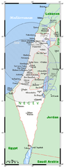
English: Coverage of Israel provided by two Arrow 2 theater-defense anti-ballistic missiles batteries, derived from their published locations (Palmachim, Ein Shemer) and range (90-100 km). |
| Date | (UTC) |
| Source |
|
| Author |
|
| This is a retouched picture, which means that it has been digitally altered from its original version. The original can be viewed here: IsraelOMC.png:
|

|
Permission is granted to copy, distribute and/or modify this document under the terms of the GNU Free Documentation License, Version 1.2 or any later version published by the Free Software Foundation; with no Invariant Sections, no Front-Cover Texts, and no Back-Cover Texts. A copy of the license is included in the section entitled GNU Free Documentation License. |
| This file is licensed under the Creative Commons Attribution-Share Alike 3.0 Unported license. | ||
| ||
| This licensing tag was added to this file as part of the GFDL licensing update. |
Original upload log
[edit]
This image is a derivative work of the following images:
- File:IsraelOMC.png licensed with GFDL-en, GFDL-user-en-with-disclaimers
- 2009-03-25T17:35:09Z Georgez 496x1301 (32830 Bytes) {{Information |Description={{en|A map showing Israel's cities and main towns, along with nearby areas. Borders shown are those generally recognized (that is, those in force before the Six-Day War) except Jerusalem city limits
Uploaded with derivativeFX
File history
Click on a date/time to view the file as it appeared at that time.
| Date/Time | Thumbnail | Dimensions | User | Comment | |
|---|---|---|---|---|---|
| current | 22:20, 29 July 2009 | 513 × 1,329 (322 KB) | NatanFlayer (talk | contribs) | borders fixed | |
| 22:05, 29 July 2009 | 513 × 1,329 (340 KB) | NatanFlayer (talk | contribs) | {{Information |Description={{en|A map showing Israel's schematic coverage by Arrow 2 theater-defense anti-ballistic missiles, based on published locations of the two batteries. This map's source is [http://commons.wikimedia.org/wiki/File:IsraelOMC.pn |
You cannot overwrite this file.
File usage on Commons
The following page uses this file:
File usage on other wikis
The following other wikis use this file:
- Usage on cs.wikipedia.org
- Usage on en.wikipedia.org
- Usage on fa.wikipedia.org
- Usage on it.wikipedia.org
- Usage on ru.wikipedia.org