File:Arrondiments d'Alèir 2017.svg
Jump to navigation
Jump to search

Size of this PNG preview of this SVG file: 800 × 587 pixels. Other resolutions: 320 × 235 pixels | 640 × 470 pixels | 1,024 × 752 pixels | 1,280 × 940 pixels | 2,560 × 1,879 pixels | 1,068 × 784 pixels.
Original file (SVG file, nominally 1,068 × 784 pixels, file size: 212 KB)
Captions
Captions
Add a one-line explanation of what this file represents
Summary
[edit]
| Description |
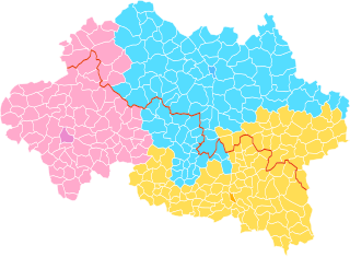
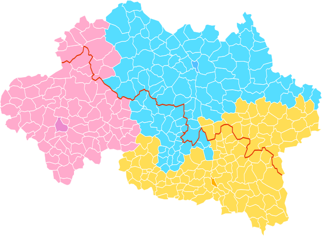
Occitan : Arrondiments d'Alèir a partir dau 1èr de genièr de 2017
031 Arrondiment de Montluçon 032 Arrondiment de Molins 033 Arrondiment de Vichèi Limit d’Occitània Chaplòcs Montluçon Molins Vichèi English: Arrondissements of Allier from the 1st January 2017 031 Arrondissement of Montluçon 032 Arrondissement of Moulins 033 Arrondissement of Vichy Northern Limit of Occitania Capitals Montluçon Moulins Vichy |
| Date | |
| Source | Own work |
| Author | Jfblanc |
Licensing
[edit]
I, the copyright holder of this work, hereby publish it under the following licenses:

|
Permission is granted to copy, distribute and/or modify this document under the terms of the GNU Free Documentation License, Version 1.2 or any later version published by the Free Software Foundation; with no Invariant Sections, no Front-Cover Texts, and no Back-Cover Texts. A copy of the license is included in the section entitled GNU Free Documentation License. |
This file is licensed under the Creative Commons Attribution-Share Alike 4.0 International, 3.0 Unported, 2.5 Generic, 2.0 Generic and 1.0 Generic license.
- You are free:
- to share – to copy, distribute and transmit the work
- to remix – to adapt the work
- Under the following conditions:
- attribution – You must give appropriate credit, provide a link to the license, and indicate if changes were made. You may do so in any reasonable manner, but not in any way that suggests the licensor endorses you or your use.
- share alike – If you remix, transform, or build upon the material, you must distribute your contributions under the same or compatible license as the original.
You may select the license of your choice.
File history
Click on a date/time to view the file as it appeared at that time.
| Date/Time | Thumbnail | Dimensions | User | Comment | |
|---|---|---|---|---|---|
| current | 22:12, 22 March 2017 | | 1,068 × 784 (212 KB) | Jfblanc (talk | contribs) | Correccion: Haut-Bocage |
| 19:38, 22 March 2017 |  | 1,068 × 784 (211 KB) | Jfblanc (talk | contribs) | Without garbled characters | |
| 19:03, 22 March 2017 |  | 1,068 × 784 (214 KB) | Jfblanc (talk | contribs) | Updated | |
| 18:51, 22 March 2017 |  | 1,068 × 784 (214 KB) | Jfblanc (talk | contribs) | Updated with commune borders and arrondissement capitals highlighted | |
| 12:45, 22 March 2017 |  | 873 × 640 (462 KB) | Jfblanc (talk | contribs) | {{Information |Description ={{oc|1=Arrondiments d'Alèir amb numèro INSEE a partir dau 1.1.2017}} |Source =Jfblanc |Author =Jfblanc |Date =22/03/2017 |Permission = |other_versions = }} |
You cannot overwrite this file.
File usage on Commons
The following page uses this file:
- File:Arrondissements d'Alèir 2017.svg (file redirect)
File usage on other wikis
The following other wikis use this file:
- Usage on cs.wikipedia.org
- Usage on nl.wikipedia.org
- Usage on oc.wikipedia.org