File:Armiesburg historical marker.jpg
Jump to navigation
Jump to search
No higher resolution available.
Armiesburg_historical_marker.jpg (640 × 480 pixels, file size: 173 KB, MIME type: image/jpeg)
Captions
Captions
Add a one-line explanation of what this file represents
| Camera location | | View this and other nearby images on: OpenStreetMap |
|---|
| Description |
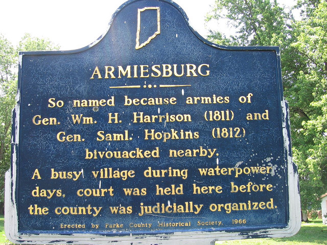
English: Historical marker for Armiesburg, located along the western side of Lafayette Road (County Road 600W) south of U.S. Route 36 and north of Armiesburg in Parke County, Indiana, United States. |
|||
| Date | ||||
| Source | Flickr | |||
| Author | Hysterical Mark | |||
| Permission (Reusing this file) |
Plaque and photo respectively:
This file is licensed under the Creative Commons Attribution-Share Alike 2.0 Generic license.
|

| This image, originally posted to Flickr, was reviewed on 15 March 2012 by the administrator or reviewer Materialscientist, who confirmed that it was available on Flickr under the stated license on that date. |
File history
Click on a date/time to view the file as it appeared at that time.
| Date/Time | Thumbnail | Dimensions | User | Comment | |
|---|---|---|---|---|---|
| current | 15:03, 15 March 2012 | | 640 × 480 (173 KB) | Nyttend (talk | contribs) | {{Location|39|46|13|N|87|21|4.5|W}} {{Information |Description={{en|Historical marker for {{w|Armiesburg, Indiana|Armiesburg}}, located along the western side of Lafayette Road (County Road 600W) south of {{w|U.S. Route 36}} and north of Armiesburg in ... |
You cannot overwrite this file.
File usage on Commons
There are no pages that use this file.
File usage on other wikis
The following other wikis use this file:
- Usage on en.wikipedia.org